1890 Rand McNally Map of Massachusetts, United States
Massachusetts-randmcnally-1893$90.00

Title
Massachusetts.
1890 (dated) 20 x 27 in (50.8 x 68.58 cm) 1 : 460000
1890 (dated) 20 x 27 in (50.8 x 68.58 cm) 1 : 460000
Description
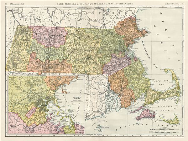
This is an example of the 1890 Rand McNally and Company map of Massachusetts, United States. It covers the entire state of Massachusetts, inclusive of Nantucket, Elizabeth Islands and Martha's Vineyard as well as adjacent parts of Rhode Island, Vermont and New Hampshire. This highly detailed map is color coded according to counties with relief shown by hachure. An inset in the lower left quadrant details the environs of Boston. Several towns, cities, railroads, mountains, rivers, islands and other topographical details are noted. This map was issued as plate nos. 30 and 31 in the 1893 edition of Rand McNally and Company's Indexed Atlas of the World- possibly the finest atlas Rand McNally ever issued.
Cartographer
Rand, McNally and Co. (fl. 1856 - present) is an American publisher of maps, atlases and globes. The company was founded in 1856 when William H. Rand, a native of Quincy, Massachusetts, opened a print shop in Chicago. Rand hired the recent Irish immigrant Andrew McNally to assist in the shop giving him a wage of 9 USD per week. The duo landed several important contracts, including the Tribune's (later renamed the Chicago Tribune) printing operation. In 1872, Rand McNally produced its first map, a railroad guide, using a new cost effective printing technique known as wax process engraving. As Chicago developed as a railway hub, the Rand firm, now incorporated as Rand McNally, began producing a wide array of railroad maps and guides. Over time, the firm expanded into atlases, globes, educational material, and general literature. By embracing the wax engraving process, Rand McNally was able to dominate the map and atlas market, pushing more traditional American lithographic publishers like Colton, Johnson, and Mitchell out of business. Eventually Rand McNally opened an annex office in New York City headed by Caleb S. Hammond, whose name is today synonymous with maps and atlases, and who later started his own map company, C. S. Hammond & Co. Both firms remain in business. More by this mapmaker...
Source
Rand McNally & Co., Rand, McNally & Co's Indexed Atlas of the World, (Chicago) 1893.
Condition
Very good. Original centerfold exhibits minor wear. Closed professionally repaired tear from left margin extending about 3 inches into the map. Text on verso.
References
Rumsey 3565.069 (1897 edition). Philips (atlases) 1026 (1898 edition).