This item has been sold, but you can get on the Waitlist to be notified if another example becomes available, or purchase a digital scan.
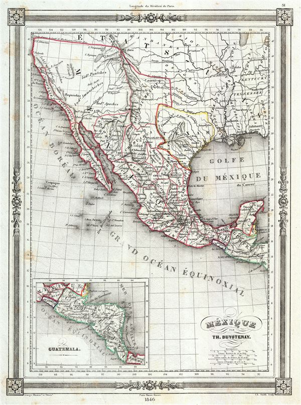
1846 Duvotenay Map of Mexico (w/ Republic of Texas)
Mexico-duvotenay-1846$250.00

Title
Mexique.
1846 (dated) 13 x 9.5 in (33.02 x 24.13 cm) 1 : 19350000
1846 (dated) 13 x 9.5 in (33.02 x 24.13 cm) 1 : 19350000
Description
This is a highly desirable 1846 map of Mexico by Thunot Duvotenay. Duvotenay published several different editions of this Mexico map - this being the most desirable due to its depictions of the ephemeral Republic of Texas. The map covers all of modern day Mexico and southwest United States. The map offers a number of fascinating elements including. The fictional rivers Jesus Maria and Wimmetchke are shown extending eastward from San Francisco Bay. The map labels the Great Salt Lake as Lake Teguayo after Jose Antonio de Alzate y Ramirez. Lake Teguayo is said by some to be the legendary homeland of the Aztecs. To the north of Lake Teguayo, today's Lake Utah is labeled Lake Timpanogos. Mexico itself is divided into its various intendancies. An inset in the lower left quadrant focuses on Guatemala. Features a beautiful frame style border. Prepared by Th. Duvotenay for publication as plate no. 31 in Maison Basset's 1846 edition of the Atlas Illustre.
Cartographer
Thunot Duvotenay (1796 - 1875) was a French geographer active in the mid 19th century. Thunot is known to have worked with several other important cartographers of his dayincluding Barbie du Bocage, Vuillemin, Charle, Levassseur and Dufour. More by this mapmaker...
Source
Maison Basset, Atlas Illustre, 1846 edition.
Condition
Very good. Blank on verso. Minor spotting near borders.