This item has been sold, but you can get on the Waitlist to be notified if another example becomes available, or purchase a digital scan.
1930 Mississippi River Commission Map of the Mississippi River w/ Flood Control
MississippiRiver-msrivercommission-1930$475.00

Title
Alluvial Valley of the Mississippi River. Southern Sheet - New Orleans District.
1930 (dated) 43 x 29 in (109.22 x 73.66 cm) 1 : 500000
1930 (dated) 43 x 29 in (109.22 x 73.66 cm) 1 : 500000
Description
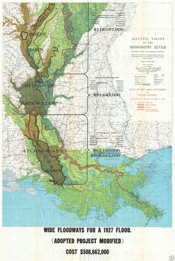
This is a 1930 Mississippi River Commission map of the alluvial valley of the Mississippi River. This map depicts the Mississippi River alluvial valley from the Arkansas-Louisiana state border on the top to the Gulf of Mexico on the bottom and from the middle of Louisiana on the left to the Mississippi-Louisiana state border on the right. New Orleans and Baton Rouge are labeled on the map, as well as Lake Pontchartrain, and the Pearl River. Overlaid on the Mississippi River Commission map is the 'Plan of the Army Engineers for Flood Control. Adopted by the Act of May 15, 1928'. This plan shows the intention of the Army Corps of Engineers to enlarge existing levees and build new levees in response to the 'Great Mississippi Flood of 1927'. This flood was the most destructive river flood in United States history, with 27,000 square miles inundated by up to 30 feet of water and over 630,000 people were affected.
The map breaks down the New Orleans District of the Mississippi River Alluvial Valley into three zones: the Boeuf Basin, the Red River Backwater, and the Atchafalaya Basin. The flow rate for both the Boeuf Basin and the Atchafalaya Basin is noted. The cost of implementing this plan is broken down for each zone by the cost of levees, land (calculated by price per acre), railways, highways, and drainage and then added together for a total of $508,662,000. The statement at the bottom of the map reads, 'Wide Floodways for a 1927 Flood. (Adopted Project Modified)'. This statement lends itself to the supposition that this map was created as a way to both explain the government's response to the flood of 1927, and convince the public that the response would be sufficient. At the same time, the government also had to justify the incredible sum of money to be allocated for the project.
This map was prepared by the Mississippi River Commission under the direction of the Secretary of War and the Supervision of the Chief of Engineers, United States Army for publication in 1930.
Condition
Very good. Blank on verso.
References
OCLC 214970790.