1780 Bellin Map of Southeastern Africa
Monomotapa-bellin-1780$250.00

Title
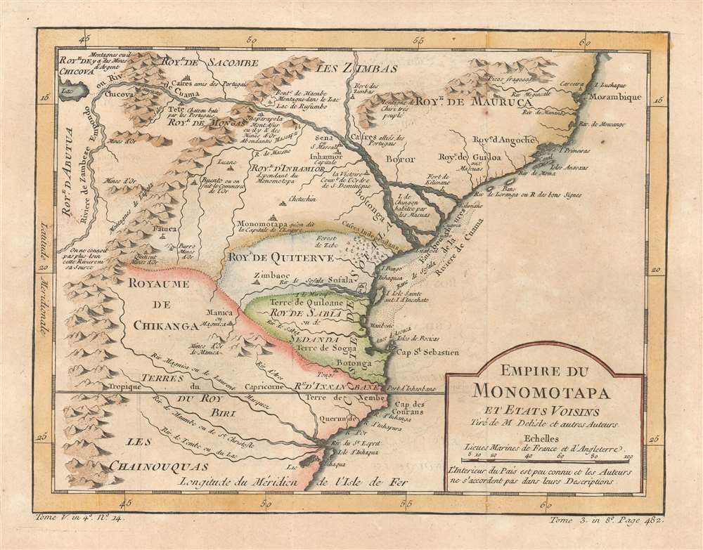
Empire du Monomotapa et Etats Voisins.
1780 (undated) 9 x 11.5 in (22.86 x 29.21 cm) 1 : 8100000
1780 (undated) 9 x 11.5 in (22.86 x 29.21 cm) 1 : 8100000
Description
This is a 1780 Jacques-Nicolas Bellin map of southeastern Africa. Centered on modern-day Mozambique, the map depicts part of the Kingdom of Mutapa, a vast empire that dominated parts of southern Africa from 1430 - 1760. Smaller kingdoms, the Kingdom of Quiterve, the Kingdom of Sabia, and the Kingdom of Chikanga, are also identified. The Zambezi River and its delta, also labeled here as the Cuama River, dominates the upper portion of the map. Short comments provide some context and label certain peoples as being 'friends of the Portuguese,' the region's gold mines, and a castle built by the Portuguese at Tete.
The Kingdom of Mutapa
The Kingdom of Mutapa, labeled here by its Portuguese name Monomotapa, was an African kingdom that encompassed portions of modern-day Zimbabwe, Zambia, Mozambique, and South Africa. Monomotapa, the Portuguese name for the kingdom, is likely a transliteration of Mwenemutapa, an African royal title, that combines Mwene meaning King and Mutapa meaning land. The kingdom's origins are unclear, as oral tradition leaves us with at least two different versions of its genesis. Nonetheless, the kingdom expanded from its founding in 1430 until 1480, when it reached its fullest extent. The Portuguese first made contact around 1512 and entered into formal relations with the kingdom in the 1560s. The first vestiges of Portuguese control arrived in 1629, when the Mwenemutapa failed in his attempt to throw out the Portuguese, was in turn deposed, and replaced by a pro-Portuguese king. This led to treaties ceding the kingdom's gold mines and making it a Portuguese vassal, but these provisions were never carried out. It was not until 1759, during a civil war for the throne, that the kingdom never recovered. The 'winners' of this war ruled a much-reduced kingdom independently of the Portuguese until 1917 when the last king of the dynasty, Mambo Chioko, was killed in battle against the Portuguese.Publication History and Census
Originally created for of Abbé Prévost's Histoire Générale des Voyages by Jacques-Nicolas Bellin, this map was published by Jean François de La Harpe's in his Abrégé de l'Histoire Générale des Voyages in 1780. Two examples of the 1780 edition of this map are cataloged in OCLC. They are part of the institutional collections at Universitätsbibliothek München in Munich and Bayerische Staatsbibliothek, also in Munich. Another example is part of the collection at the University of Illinois Urbana-Champaign. The works by Prévost and de la Harpe are well represented institutionally.Cartographer
Jacques-Nicolas Bellin (1703 - March 21, 1772) was one of the most important cartographers of the 18th century. With a career spanning some 50 years, Bellin is best understood as geographe de cabinet and transitional mapmaker spanning the gap between 18th and early-19th century cartographic styles. His long career as Hydrographer and Ingénieur Hydrographe at the French Dépôt des cartes et plans de la Marine resulted in hundreds of high quality nautical charts of practically everywhere in the world. A true child of the Enlightenment Era, Bellin's work focuses on function and accuracy tending in the process to be less decorative than the earlier 17th and 18th century cartographic work. Unlike many of his contemporaries, Bellin was always careful to cite his references and his scholarly corpus consists of over 1400 articles on geography prepared for Diderot's Encyclopedie. Bellin, despite his extraordinary success, may not have enjoyed his work, which is described as "long, unpleasant, and hard." In addition to numerous maps and charts published during his lifetime, many of Bellin's maps were updated (or not) and published posthumously. He was succeeded as Ingénieur Hydrographe by his student, also a prolific and influential cartographer, Rigobert Bonne. More by this mapmaker...
Source
De la Harpe, Abrégé de l'histoire générale des voyages. (Paris) 1780.
Condition
Very good. Exhibits some offsetting.
References
OCLC 635220270 ; 163337284.