Title
United Provinces. No. 53 O Naini Tal. Almora, Garhwal, Moradabad and Naini Tal Districts and Rampur State.
1943 (dated)
25 x 16.25 in (63.5 x 41.275 cm)
1 : 253440
Description
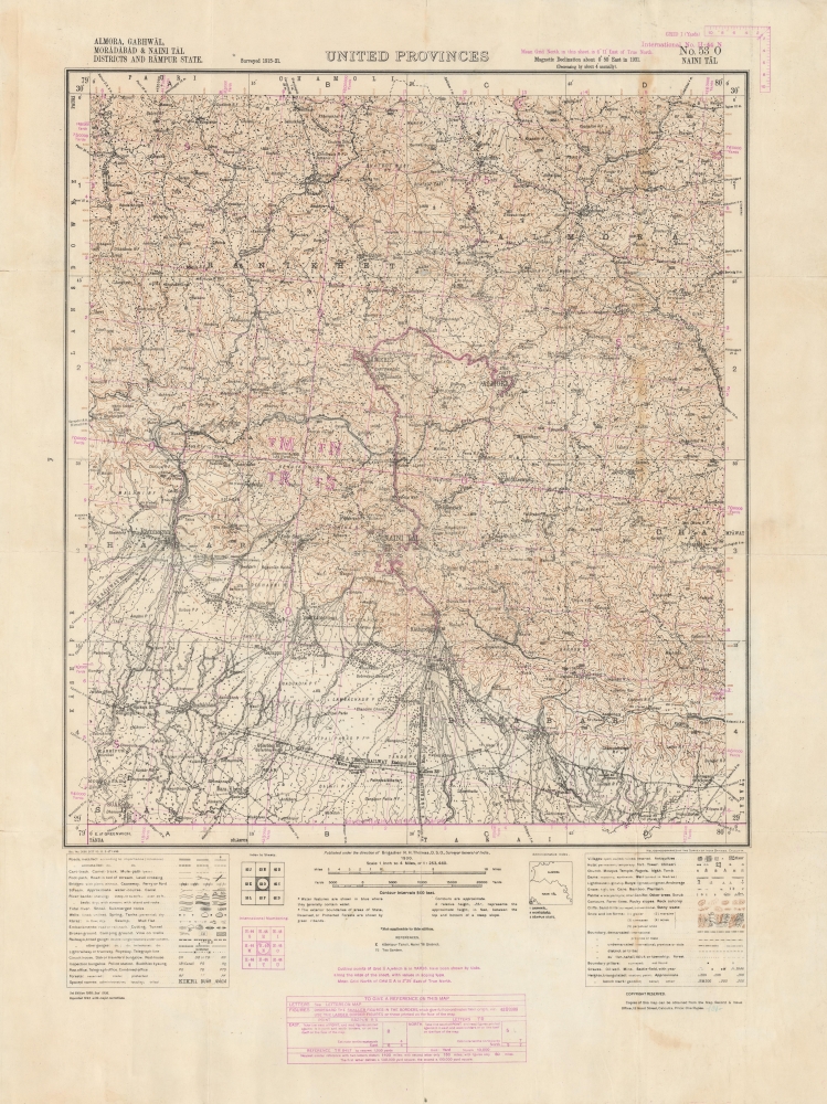
An impressive 1943 zincographic Survey of India map of Nainital (here as Naini Tal) and environs in the United Provinces (now Uttarakhand). This picturesque region lies in the foothills of the Himalayas in northern India, near Nepal's western border with India.
A Closer Look
Coverage includes the title city of Nainital as well as the nearby cities of Haldwani, Almora, and Ranikhet, and the forested and mountainous countryside surrounding them. As the crow flies, Nainital is about 150 miles from Delhi and 100 miles from Dehradun, where the Survey of India's main offices were located. Legends at bottom reveal a bewildering variety of features noted on the map, impressive even by the standards of the Survey of India. Roads and paths of various types and qualities are documented, as well as a range of waterways, railways, post offices, different trees and grasses, and houses of worship, just to name a few. Purple overprint grid coordinates, explained in a purple table at bottom, add even more detail and practical information.
The Oudh and Tirhut Railway, which predominates among the rail lines displayed, had just been formed on January 1, 1943 by the merger of several other lines, including the Rohilkund and Kumaon Railway (R and K, still listed separately here). As can be seen, the railways were mostly confined to the lower elevations in the southern portion of the area covered, while further north, unpaved (unmetalled) roads, cart tracks, and mule paths were the norm. Zincography
At bottom-right, the map is noted as being heliozincographed at the Survey of India Offices in Calcutta. Zincography, or 'zinco' for short, is a planographic printing process similar to lithography. The process was known as early as 1801, when lithography inventor Alois Senefelder (1771 - 1834), in his original English patent for lithography, mentioned the possibility of using zinc plates over traditional limestone. The first zincographic process was subsequently patented in 1834 by Federico Lacelli. The process operates like traditional stone-lithography wherein ink applied to the plate is repelled by the hygroscopic areas, and attracted to the fuchsine areas. It offers several advantages, most importantly, zinc plates are lighter and cheaper than lithographic stones, economizing the process considerably. As such, the process was embraced by various cartographic agencies that demanded mobility and economy, among them the British Ordinance Survey, the French Bureau Topographique, and many military mapping agencies. It was followed by photo-zincography, photo-lithography, and photogravure.Publication History and Census
This map was originally produced by the Survey of India in 1930, relying on surveys conducted between 1915 and 1921. A second edition was printed in 1936 and then the present edition in 1943, 'with major corrections.' The only known institutional holding of this map in any edition is held by the National Diet Library; according to the library's description, it was reproduced and slightly modified by the Japanese Army General Staff Headquarters (參謀本部) during the Second World War.
Cartographer
Survey of India (1767 - Present) is India's central engineering agency in charge of mapping and surveying the country. It was founded in 1767 by Major James Rennell, who took the post of first Surveyor General, with the mission to map and consolidate the territories of the British East India Company. The Survey undertook the Great Trigonometrical Survey between 1802 and 1852 in an attempt to accurately measure the Indian Subcontinent - considered one of the greatest feats of mapping of all time. It also sponsored clandestine surveys, at times disguised as Buddhist pilgrims, to infiltrate and map Tibet, then a closed country. With India's independence in 1947, the Survey was folded into the new Indian government, which it remains part of to this day. More by this mapmaker...
Condition
Good. Wear and toning along fold lines, with some loss at fold intersections. Backed on archival tissue.
References
OCLC 676028602 (Imperial Japanese Army edition).