
This item below is out of stock, but another example (left) is available. To view the available item, click "Details."
Details
1889 Ewer Map of Nantucket Island, Massachusetts w/ Old Colony Line Ad
$1,000.00
1889 Ewer Map of Nantucket Island, Massachusetts w/ Old Colony Line Ad
Nantucket-ewer-1889-2$450.00

Title
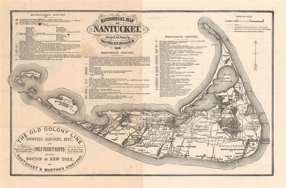
Historical Map of Nantucket.
1889 (undated) 9 x 14.25 in (22.86 x 36.195 cm) 1 : 90000
1889 (undated) 9 x 14.25 in (22.86 x 36.195 cm) 1 : 90000
Description
This attractive c. 1886 map is a reduced version of Reverend F. C. Ewers important 1869 map of Nantucket. Printed in Nantucket, this variant was issued by the Old Colony Line in various formats from roughly 1872 to 1889. A medallion in the lower-left promotes the 'Old Colony Line' as the 'Shortest, Quickest, Best, and Only Direct Route between Boston or New York and Nantucket and Martha's Vineyard.' Features three columns of text breaking down the history of Nantucket from its discovery by Bartholomew Gosnold in 1602 to the laying of the first communications cables between Nantucket and the mainland in 1886 - hence our dating.
The Ewer Map
The Nantucket historian Joseph Garver provides an excellent descriptionEwer’s map provides a detailed synopsis of Nantucket’s history, beginning with Gosnold’s sighting of the island in 1602. The chronological table identifies the major stages in Nantucket’s development-its early settlement and land divisions, the evolution from shore to deep-sea whaling, the establishment of religious and educational institutions, and the development of the transportation network connecting Nantucket with the mainland (and Nantucketers with one another). Ewer also notes events that marked the transition from one era to the next-the first island whaler to seek its prey in the Pacific (1791), the death of the last Indian (1822), the great fires of 1836 and 1846, and the first gaslight in 1854. In a more graphic form the map indicates the sites of old settlements and burial grounds, as well as the boundaries of sachem rights, the former shoreline, old fishing stages, and whaling stations. (Garver, G. Surveying the Shore, p. 115.)
The Present Map
The present map follows the updates and modifications to the Ewer plan introduced by J. B. Swain in or around 1886. Swain's revisions of the large-scale original were intended for a reissue promoting the Hotel Nantucket, shown here on Brant Point. The hotel was a response to growing 'summering' interest around Nantucket and was the first major hotel on the island. We know Swain was a Nantucket hotelier in his final years, so his association with the Hotel Nantucket, while not fully verified, is almost certain. We also know that the hotel was built on 'Society of Friends' land, and that Swain was closely associated with the 'Friends' in Nantucket. In any case, Swain massively revised the Ewer ma. He further updated it to reflect recent changes on the island, including the construction of the Hotel Nantucket, the Nantucket Railroad from the harbor to Surfside and on to Siasconset, and life-saving stations at Coskata and Muskeget Island. He also notes, in 1877, the 'Great Temperance Movement.' The table of historical events has been updated to 1886 and reflects these and other developments.Old Colony Line
The Old Colony Line was a subsidiary of the Old Colony Railroad, which from 1844, developed and operated a rail line between Boston and Plymouth. The Old Colony Railroad, by acquiring or merging with its competitors, became the dominant railroad in southeastern Massachusetts. They expanded their network with steamship service between New York City and Fall River. In 1872, they inaugurated the Old Colony Line, a steamer between Woods Hole, Martha's Vineyard, and Nantucket. The Old Colony Railroad was acquired, in 1893 by the New York, New Haven and Hartford Railroad. Some of the railroads established by the Old Colony Railroad remain in operation to this day, among them the Old Colony and Newport Railway.Publication History and Census
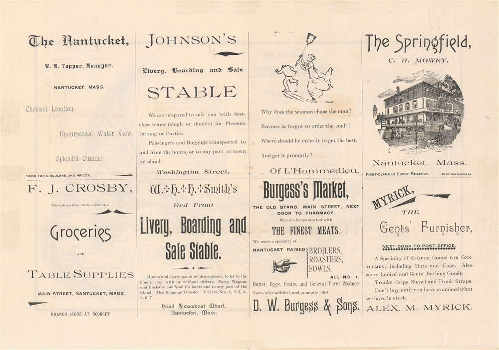
This map has a complex, confusing, and little researched publication history. It was originally drawn and published by Ferdinand Cartwright Ewer in 1869. That edition was large, measuring more than 40 inches wide. It was reissued around 1886 for the opening of the Nantucket Hotel. Around the same time, a reduced version emerged to promote the Old Colony Line, with a large medallion to this effect in the lower right. This edition is the most common and was republished in many variations. The timeline on most such examples terminated in 1886. Examples were published in books, such as Nantucket in a Nutshell, as well as in separate issue pamphlets, as here, passed out at the Nantucket Hotel and other tourist 'hot spots.' These scarcer more ephemeral issued, often with advertising on the verso, as here, are particularly desirable. Examples are scarce and typically in poor condition.Cartographer
Ferdinand Cartwright Ewer (1826 - 1883) was born on May 22nd of 1926 in town of Nantucket on the Massachusetts island of the same name. Ewer's father, a prominent Nantucket businessman, moved his family to Providence Rhode Island when Ferdinand was three and then, further afield, to New York City. It was not until his 13th year that Ewer returned to Nantucket where he would remain until 1844 when was matriculated at Harvard. There he grew intellectually and strayed from his religiously ideological upbringing, embracing atheism. Shortly following his graduation in 1848, Ewer, like many others, was drawn westward by the lure of the California Gold Rush. "I have no gold fever," he says pathetically in his diary, "I only desire not to starve." In San Francisco he worked as a clerk in the claims office and later as newspaper reporter with The Alta Californian. In a tale typical of the Wild West, a bar room conversation in a mining town inspired Ewer to change his life, abandon his atheism, and became a Reverend of the Episcopal Church. As Reverend, Ewer generated a popular following in San Francisco. Nonetheless, in time he decided to move back to the east coast and, eventually, became the rector of New York City's Christ's Church. A highly educated man, Ferdinand devoted much of his intellectual energy in reconciling the positions of science with religion. To the chagrin of his Episcopalian superiors, Ewer believed that the premises of Darwinism, astronomy, and medicine were in fact compatible his faith. Eventually, Ewer's scientific leanings drove him from the Christ Church, at which point he established the New York church of St. Ignatius of Antioch, where he remained to his death in 1883. It was sometime during his tenure in New York that Ewer composed his famous map of Nantucket. More by this mapmaker...
Condition
Good. Exhibits toning. Light wear along original fold lines. Closed margin tears professionally repaired on verso. Printed advertisements on verso.
References
OCLC 83915259. Boston Public Library, Leventhal Map Center, G3762.N3 1869 .E9 (Original Ewer Map). National Library of Australia, MAP RM 1548. Congdon, Charles Taber, 'Memoir of the Reverend Ferdinand Cartwright Ewer, S.T.D.' from Sanctity and Other Sermons by the Rev. Ferdinand Cartwright Ewer, S.T.D.. Project Canterbury, pp xxvii-lxxxiii.