1944 Navy Education Service Map of the Mediterranean and North Africa / Map of Southeast Asia
NavWarMap1-navy-1944$850.00


Title
NavWarMap No. 1 The Mediterranean. / NavWarMap No. 2 The South China Sea Area
1944 (dated) 38.75 x 58.5 in (98.425 x 148.59 cm) 1 : 2782000
1944 (dated) 38.75 x 58.5 in (98.425 x 148.59 cm) 1 : 2782000
Description
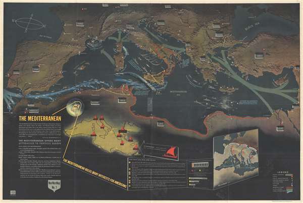
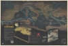
This is a 1944 Navy Department pictorial map of the Mediterranean region with a Navy Department pictorial map of Southeast Asia on the verso. This visually stunning map summarizes Allied operations in the Mediterranean theater through the Allied invasion of Italy in September 1943 and the early months of the Pacific War on the other side.
The next Allied operation, which is also illustrated here, was Operation Husky, the Allied invasion of Sicily. At that point, the invasion fleet of over 2,000 vessels was the largest ever assembled. This record would not last a year, as the Allied invasion of Normandy would bring together an even larger fleet. Following the successful campaign in Sicily, the Allies invaded southern Italy, which is also noted here. The Allied forces landed at Salerno, with smaller landings in Calabria and Taranto.
An Overview of the War in the Mediterranean
Full of information about combat actions throughout the Mediterranean, crucial details about the course of hostilities in the region are included. Before Operation Torch, the most important Mediterranean battles were fought in the skies over Malta. Then a British colony, German and Italian forces laid siege to the island, because, as Rommel accurately stated, 'without Malta the Axis will end by losing control of North Africa.' Churchill referred to the island as an 'unsinkable aircraft carrier' which was resupplied with fighter aircraft twice by the U.S.S. Wasp, an American aircraft carrier (instead of the three times stated on the map). Operation Torch, the Allied amphibious landings in North Africa, were the first major operation in which American forces participated. The allies landed over 100,000 troops to take on Vichy French forces in Morocco and Algeria, while Field Marshal Bernard Montgomery, commander of the British 8th Army, continued to pursue Erwin Rommel and the Afrika Korps from Egypt through Libya into Tunisia, where American troops linked up with Montgomery's army. Nazi Germany reacted strongly to the Allied invasion by itself invading Unoccupied France the following day, which led to the scuttling of the French Navy at Toulon, as here noted.The next Allied operation, which is also illustrated here, was Operation Husky, the Allied invasion of Sicily. At that point, the invasion fleet of over 2,000 vessels was the largest ever assembled. This record would not last a year, as the Allied invasion of Normandy would bring together an even larger fleet. Following the successful campaign in Sicily, the Allies invaded southern Italy, which is also noted here. The Allied forces landed at Salerno, with smaller landings in Calabria and Taranto.
A Closer Look at the Map
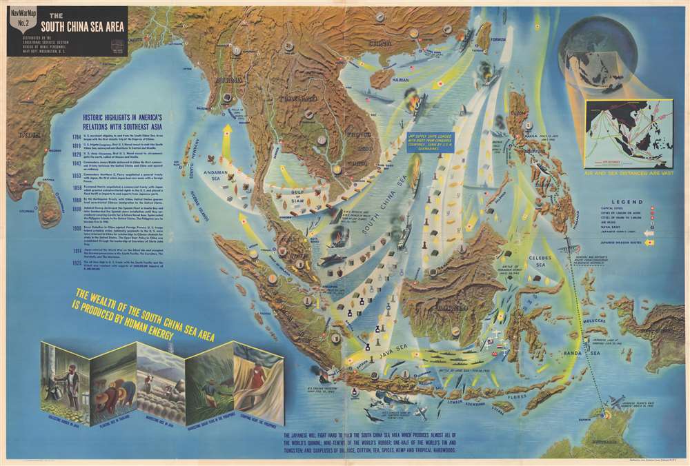
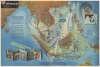
As stated above, numerous engagements throughout the Mediterranean theater are illustrated, including the Allied invasions of North Africa (Operation Torch) and Sicily (Operation Husky). Countries in southern Europe, the Middle East, and North Africa are labeled, along with their capitals and other large cities. Naval bases and airfields are indicated by different symbols, along with the routes of the British 8th and 1st Army (in red) and the U.S. 5th and 7th Army (in yellow). General information about the Mediterranean region is situated on the left. This information was included because the Navy education sections believed that troops who understand the greater context of why they are fighting are better soldiers. To that end, a brief history of American military involvement in the Mediterranean is also included, along with the locations of ancient sea powers, such as Phoenicia, Rome, Athens, Crete, and Carthage, and the more recent sea powers Genoa and Venice.The Verso: NavWarMap No. 2 The South China Sea Area
The Beginning of World War II in the Pacific
A part of the world rich in natural resources, Southeast Asia was a target ripe for invasion by the Imperial Japanese. Per the map, 'the South China Sea Area…produces almost all of the world's quinine; nine-tenths of the world's rubber; one-half of the world's tin and tungsten; and surpluses of oil, rice, cotton, tea, spices, hemp, and tropical hardwoods.' One of the major difficulties faced by the Japanese during World War II was the nearly-complete lack of natural resources on the Japanese home islands. In order to prosecute the war, which the Imperial Japanese believed was their right, these resources were a necessity. Japanese forces began attacks in the region on December 8, 1941, the same day as the surprise attack on Pearl Harbor. Quick, systematic victories followed, mostly due to the fact that British and American forces in Southeast Asia underestimated the capability and the zeal of their enemy. Until the beginning of the Guadalcanal Campaign in the Solomon Islands in August 1942, the Japanese military scored victory after victory in Southeast Asia and stood nearly unopposed.A Closer Look at the Map
The progression of Japanese troops throughout the region is easily traced, with yellow arrows indicating routes of the Japanese advance, with white arrows illustrating which resources they extracted from the territories they conquered. Specific events, such as the fall of Manila, Corregidor, and Bataan in the Philippines, and the sinking of the H.M.S. Repulse and the H.M.S. Prince of Wales are illustrated, labeled, and dated. General Douglas MacArthur's escape from the fortress on Corregidor is highlighted, with the map illustrating his route to Darwin, Australia in order to continue to command Allied troops in the Southwest Pacific after the fall of the Philippines. Air fields and naval bases are indicated throughout the region, along with capitals and other cities. An inset map of the region on the upper right provides both air and sea distances between cities in the region, allowing the viewer to better comprehend just how much area of the world this theater covered. 'Historic highlights' of America's involvement in Asia are provided along the left, along with sketches of indigenous people gathering 'the wealth of the South China Sea Area'.The NavWarMap Series
NavWarMap No. 1 The Mediterranean is part of a series of six maps that was created by the Bureau of Naval Personnel, which was part of the Navy Department. These include:- NavWarMap No. 1 The Mediterranean
- NavWarMap No. 2 The South China Sea Area
- NavWarMap No. 3 World War II in the North Sea Area
- NavWarMap No. 4 The North Pacific Area
- NavWarMap No. 5 Southwest Pacific
- NavWarMap No. 6 We Fight a Global War
Publication History
This map was created within the Bureau of Naval Personnel, most likely by the training division, and distributed by the Educational Services Section. NavWarMap No. 2 The South China Sea Area is printed on the verso.Condition
Very good. Wear along original fold lines. Verso repairs at some fold intersections and to fold separations. Old recto repair. NavWarMap No. 2 The South China Sea Area on verso.
References
Curtis, P. and J. Pedersen, War Map p. 184-87. Rumsey 8760.001. OCLC 85450222.