1869 Stebbins and Lloyd Map of Nebraska, Dakota, Montana, Idaho
NebraskaNorthernTerr-stebbinslloyd-1869$500.00

Title
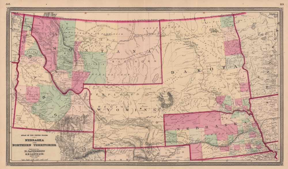
Nebraska and Northern Territories.
1869 (undated) 15.25 x 25.75 in (38.735 x 65.405 cm) 1 : 3000000
1869 (undated) 15.25 x 25.75 in (38.735 x 65.405 cm) 1 : 3000000
Description
This is an 1869 Henry Stebbins and H. H. Lloyd map of Nebraska and the Northern Territories exhibiting an ephemeral configuration of the northern plains. Nebraska, Idaho, and Montana are recognizable, but 'Dakota' contains North and South Dakota. Wyoming is labeled for the first time and still includes the previous identifier 'Unexplored Territory.'
Collector William Resor points out that in addition to adding the placename Wyoming, this state of the map is also important for showing the Union Pacific Railroad complete beyond Bridger Pass: the first state of the map, which did not name Wyoming, had the Union Pacific complete only to the Laramie River.
Collector William Resor points out that in addition to adding the placename Wyoming, this state of the map is also important for showing the Union Pacific Railroad complete beyond Bridger Pass: the first state of the map, which did not name Wyoming, had the Union Pacific complete only to the Laramie River.
Solidifying Boundaries in the West
The configuration of the western United States (with the Dakota Territory appearing as two squares) lasted only four years and came to an end just before this map's publication. In 1863, the Idaho Territory was created out of the Dakota Territory (Dakotas, Montana, and northern Wyoming). This new territory removed modern-day Montana and the northern half of modern-day Wyoming from the Dakota Territory, as well as most of the Nebraska Territory's panhandle. Then, in 1864, with the creation of the Montana Territory out of the Idaho Territory, what would become Wyoming was attached to Dakota, creating an awkward 'two square' configuration illustrated here (with the addition of the Wyoming label). Wyoming Territory was created on July 25, 1868, and was made mostly square, just as it is today. Given the presence of the vertical dashed line between Montana and Nebraska, it is likely that Stebbins and Lloyd were working on this map while the legislation establishing the Wyoming Territory was being debated in Congress. However, when Stebbins and Lloyd reissued this map, the extension in northwestern Wyoming remained. When Congress created the Wyoming Territory, this extension was divided between Idaho and Montana, creating the modern-day borders. The continued presence of the extension on Wyoming suggests that Stebbins and Lloyd did not want to reengrave the plate completely but only add the name Wyoming. The present example is the second edition of the map, with the only change being the addition of the label for Wyoming.A Closer Look
A contrast in detail and settlement, counties in Nebraska and eastern Dakota are shaded different colors, creating an intriguing disparity with the monotones in Minnesota and Iowa. Cities and towns are labeled, with few settlements appearing farther west. Most of the western settlements are situated along the Union Pacific Railroad route as it winds across Nebraska and through Wyoming to the Great Salt Lake. The Pacific Telegraph Route follows the same route, although along the North Fork of the Platte River through western Nebraska and Wyoming. The Pike's Peak and California Express Route is illustrated and labeled, as is an 'Overland Route to the Gold Mines' in Montana and Idaho. Two proposed routes for the Northern Pacific Railroad are illustrated from Minnesota across the Dakota Territory, through the Montana and Idaho territories to the map's left border. A beautiful illustration of the Black Hills appears in the Dakota Territory between Montana and Nebraska.Publication History and Census
This map was created from surveys directed by H.F. Walling and published for Henry Stebbins by H. H. Lloyd and Company in Stebbins' Atlas of the State of Ohio From Surveys under the Direction of H. F. Walling; To which is added an Atlas of the United States in 1869. The separate map is not cataloged in OCLC or elsewhere, but the atlas appears in a dozen collections across the United States. At least two editions of the atlas were published, the first in 1868 and the second in 1869.CartographerS
Henry Searls Stebbins (November 16, 1835 - June 22, 1898) was an Ohio based map publisher active in the second half of the 19th century. Stebbins was bornin Albany, New York, son of Rowland Stebbins. He studied at the 'State Normal College'. He worked as a School Commissioner in Erie County, New York, for six years. In 1867 he published an 'Atlas of Ohio'. He was involved in the book trade in Toledo, Ohio, from 1868 to 1872, and in 1874 resumed the map publishing business, continuing in that business in Chicago until 1892, when he retired from active business life. More by this mapmaker...
H.H. Lloyd & Company (fl. 1860 - 1890) were 19th century American map and atlas publishers based in New York City. They should not be confused with the competing New York firm with of a similar name, J. T. Lloyd, with whom H. H. Lloyd had a ongoing conflict. The firm was founded by H. H. Lloyd and Benjamin S. Demarest in 1860. The H. H. Lloyd firm published numerous atlases, wall maps, and gazetteers before, during and after the American Civil War. These include some of the best maps of the period, many of which were used as battle plans by various Civil War generals on both sides of the conflict. From various offices around the city, the H.H. Lloyd firm worked with other prominent firms of the period including H. S. Stebbins, Warner and Beers to produce numerous state and county atlases. Around 1880 Demarest took full control of the firm, possibly suggesting that Lloyd either died or retired. Though H. H. Lloyd and Company continued to produce maps well in to the 1880s, the firm lost much of its momentum and eventually, by 1890, closed its doors. H. H. Lloyd is sometimes confused with J. T. Lloyd, another map publisher of the period who produced a small number of United States and regional maps sympathetic to the Confederacy. Both H. H. Lloyd and B. Demarest were Union supporters, Demarest having served as a Major in the Union Army. Learn More...
Source
Stebbins, H.S., Atlas of the State of Ohio From Surveys under the Direction of H. F. Walling; To which is added an Atlas of the United States, (New York: H. H. Lloyd) 1868.
Condition
Good. Light wear along original centerfold. Parallel fold one inch to the left of the centerfold extending entire height of map reinforced on verso.
References
Rumsey 4726.042.