1930 Reynolds Pictorial Map of New Bedford, Massachusetts
NewBedford-reynolds-1930$225.00

Title
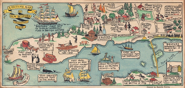
A Picture Map of New Bedford Tercentenary 1930.
1930 (dated) 6.5 x 13.25 in (16.51 x 33.655 cm) 1 : 20000
1930 (dated) 6.5 x 13.25 in (16.51 x 33.655 cm) 1 : 20000
Description
A charming 1930 pictorial map of New Bedford, Massachusetts designed by Reynolds Printing for the 1930 Tercentenary. Oriented to the east, this map cover from Clarks Clove to Nobscot and as far inland as Pope's Island and the Fairhaven Bridge. The map focuses on historical sites and events which are presented as annotated vignettes. Bright, colorful, and whimsical.
Condition
Very good. Minor toning.