This item has been sold, but you can get on the Waitlist to be notified if another example becomes available, or purchase a digital scan.
1826 / 1677 Pendleton / Foster Map of New England
NewEngland-pendleton-1826$500.00

Title
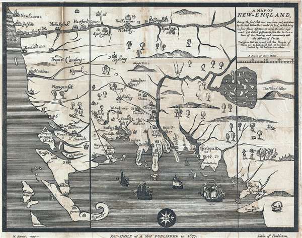
A Map of New-England : being the first that ever was here cut, and done by the best pattern that could be had, which being in some places defective, it made the other less exact: Yet doth it sufficiently show the scituation of the country and conveniently well the distances of places : The figures that are joyned with the names of places are to distinguish such as have been assaulted by the Indians from others.
1826 (dated) 12 x 15.5 in (30.48 x 39.37 cm) 1 : 850000
1826 (dated) 12 x 15.5 in (30.48 x 39.37 cm) 1 : 850000
Description
This is the Moses Swett 1826 edition of John Foster's 1677 map of New England, the first map printed in America. The map, here as an early 19th century lithograph, was originally printed as a woodcut on single plate. Oriented to the West, the map covers the Massachusetts Bay Colony from Newhaven, Connecticut to Portland Maine and Pemaquid Point, and from the Connecticut River, to Cape Cod and Nantucket. It includes a reasonably accurate mapping of the Connecticut River. The outsized lake near the 'Wine Hills' is Lake Winnipesaukee. Although distorted in size, it is placed with fair accuracy and correctly filled with numerous smaller islands. The overall work is crude by comparison to European maps of the same period, but charming in its idiosyncrasy and significant historically.
Foster prepared the map for issued in Reverend William Hubbard's 1677 Narrative of the Troubles with the Indians in New-England, the earliest accurate account of King Philip's War (1675-1678). King Philip's War, also known as the Frist Indian War, was fought between American Indians in present-day New England and English colonists over land and guns. The towns on this map that have a numerical reference are those that were attacked by the American Indians.
Although this is an 1826 facsimile of the original map, it is important in its own right. It was issued to illustrate the 1826 expanded John Davis 5th edition of Nathaniel Morton's New England's Memorial. The map one of the first prepared by Moses Swett and published by John and William Pendleton, an important American lithographic firm.
CartographerS
Pendleton's Lithography (1825 – 1836) was an American lithography firm active in Boston during the early 19th century. The firm was founded by brothers John and William S. Pendleton. Little is known of John, but William apparently moved to Boston from Montreal, Canada with Alexander McKenzie, a copper plate engraver. The two set up business with Abel Bowen from about 1820 to 1825. Around this time John Pendleton entered the picture. He and William purchased some lithographic tools from a Boston merchant named only Thaxter, who apparently acquired them in Europe but did not understand their use. The Pendleton's subsequently became the first lithographers in Boston. Their work was respected for portraiture, landscape prints, music covers, and other illustrations. Among William Pendleton's apprentices are the famous 19th century lithographers Benjamin F. Nutting and Nathaniel Currier (of Currier and Ives). John Pendleton retired from the firm in 1828, but it continued to operate under William. William, in turn, sold the firm to his bookkeeper, Thomas Moore, who changed the name but maintained the same business practices. In 1840, Moore sold out to Benjamin W. Thayer. Pendleton's Lithography was based in three separate locations in Boston: Harvard Place (1825-1826), Graphic Court (1826-ca.1832), and finally Washington Street (ca.1836). More by this mapmaker...
Moses Swett (1804 - December 20, 1838) was an American artist, lithographer, and draughtsman. Swett worked for a time with the Pendleton Lithography firm of Boston before relocating in 1830 to Baltimore and partnering with George Endicott to found Endicott and Swett, located in Graphic Hall. In 1831 the partners relocated again, this time to New York City. The partnership dissolved in July of 1834, and Swett began to publish independently in New York. In 1837, he relocated to Washington D.C. where he issued several political cartoons. Swett returned to Boston in 1838 where he died of unknown causes on December 20. Learn More...
Condition
Very good Even toning and offsetting. Some wear on fold lines. Repair left upper margin. Map backed on archival tissue.
References
OCLC 128326743. Newberry Library VAULT Ayer 171 .H8 1677. McCorkle, B. New England in Early Printed Maps, #677.3 (original London edition). Ristow, W., 'Maps by Pendleton’s Lithography', The Map Collector no.21 (December 1982), pp. 26-31.