This copy is copyright protected.
Copyright © 2024 Geographicus Rare Antique Maps
1861 Kitchell Wall Map of New Jersey
NewJersey-kitchell-1861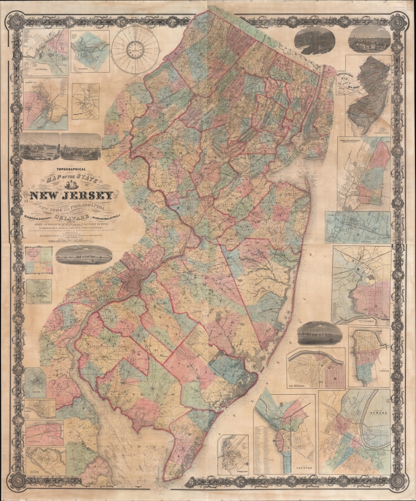


William Kitchell (April 21, 1827 - December 29, 1861) was a geologist and cartographer active in New Jersey during the middle part of the 19th century. Kitchell was born in East Madison, Morris County, New Jersey. He briefly studied at Rutgers College before dropping out to study medicine at the University of New York. He later took a position teaching Natural Sciences at the Newark Institute. Around 1850, finding his calling in this field, Kitchell proceeded to Germany in order to pursue a degree at the Mining School of Freiberg. On his return, in 1854, he was appointed to the office of State Geologist of New Jersey with a commission to produce a geological survey and accompanying topographical map of the state. A failure in legislative appropriations led to the position of State Geologist being abolished in 1860. Kitchell successfully lobbied for a reinstatement of the position and in 1860 was giving permission to continue work, though at his own expense, on his topographical map and geological survey. Later that year Kitchell published his cardinal work, the Topographical Map of New Jersey, arguably the largest and most detailed map of New Jersey ever made. One year later, in 1861, Kitchell unexpectedly died of an unknown acute illness, leaving his assistant, George H. Cook, to continue the Geological Survey, which was finally published in 1868. More by this mapmaker...
G. M. Hopkins Company (1865 - 1940; 1943 - today) was an American civil engineering and surveying firm based in Philadelphia. Founded in Philadelphia in 1865 by brothers G. Morgan and Henry Hopkins as G.M. Hopkins and Company, the firm focused primarily on real estate plat maps of the Eastern seaboard. It is unknown exactly who G.M. Hopkins was. The 'G.M.' either stands for Griffith Morgan or George Morgan. Three possibilities exist for this happenstance: it is possible that the compilers of early Philadelphia directories were negligent, G.M. Hopkins changed his first name, or two G.M. Hopkins worked for the firm. The firm published 175 plat maps atlases depicting cities, counties, and townships in eighteen states and the District of Columbia, and were among the first to create a cadastral atlas. Henry Hopkins supervised much of the surveying work and was credited with creating two maps in 1860 and 1861. He also served as the chief assistant. G.M. retired in 1900 (and died the following year), which allowed Henry to take control of the business which he renamed the G.M. Hopkins Company in 1902. Henry retired in 1902 and sold the business to George B.C. Thomas, who had been working for the firm since 1896 as an engraver. Henry Hopkins died in 1921. The G.M. Hopkins Company was purchased by the Franklin Survey Company of Philadelphia in 1943 and continued publishing atlases using the Hopkins imprint. In 1986 the company was renamed Franklin Maps and is still in operation today. Learn More...
Robert Pearsall Smith (February 1, 1827 - April 17, 1898) was an American map maker active in Philadelphia from the middle to late 19th century. Smith was born to a Quaker family in Philadelphia, all librarians and publishers. Robert Pearsall originally ran a law bookstore at 19 James Street, Philadelphia. It was not until 1846 that Smith began producing maps in collaboration with this father, John Jay Smith, and brother, Lloyd P. Smith. One year earlier, in 1845, John Jay, then librarian at the Library Company of Philadelphia and Loganian Library, acquired the American rights to the anastatic process of transfer lithography. In February of 1846 he and his two sons founded the Anastatic Office, a printing concern based on the anastatic process located at 317 Market Street, Philadelphia. The Anastatic Office produced numerous copies and reissues of historic documents and maps from the Library Company's collection before being dissolved in 1847. In the same year Robert Pearsall opened a printing establishment under his own name at 144 Chestnut Street. In 1858, he joined forced with the Swiss-American engraver Frederick Bourquin (1808 - 1897) under the imprint 'F. Bourquin and Company' (602 Chestnut Street). Smith retired suddenly and inexplicably from the printing business around 1865. Smith was also deeply religious, a lay leader in the Holiness Movement in the United States and the Higher Life Movement in Great Britain. Smith and his wife, Hannah Tatum Whitall, first crossed the Atlantic to preach in England, Germany and Switzerland in 1873. They returned in 1875, preaching in Brighton, where Smith supposedly had an affair with an American writer. In, 1888, his entire family moved to England. Learn More...
Copyright © 2024 Geographicus Rare Antique Maps | Geographicus Rare Antique Maps
This copy is copyright protected.
Copyright © 2024 Geographicus Rare Antique Maps