1878 Hardee Map of New Orleans, Louisiana and Vicinity
NewOrleans-hardee-1878$6,000.00

Title
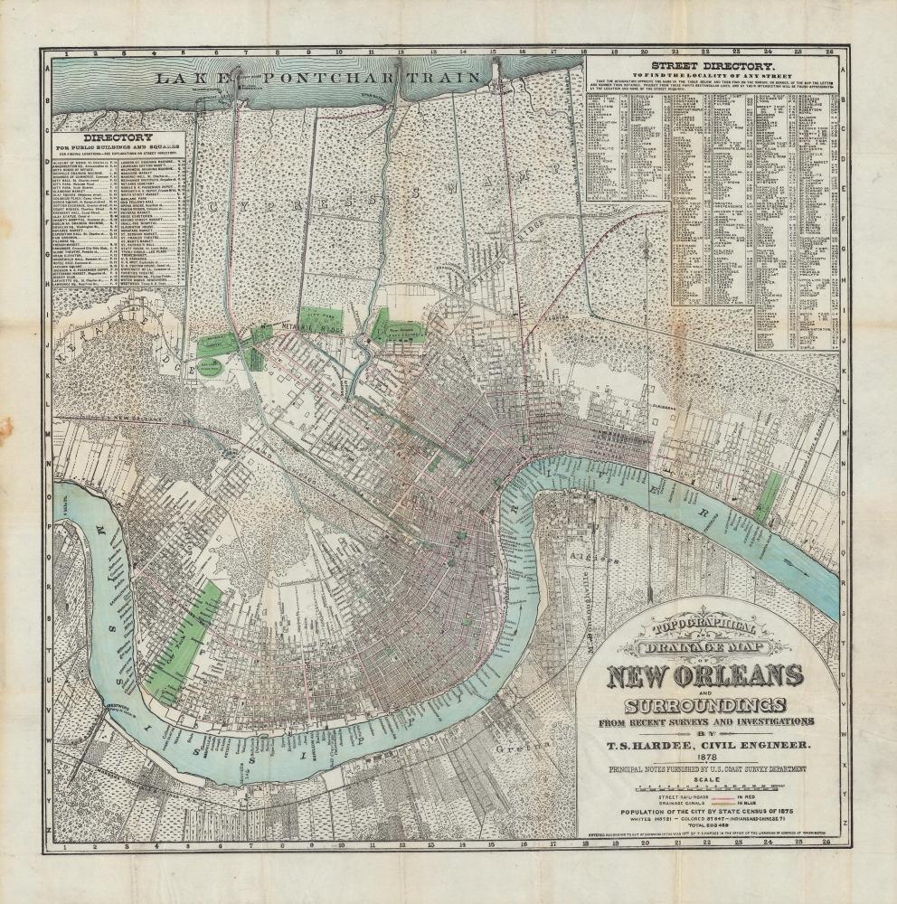
Topographical and drainage map of New Orleans and surroundings, from recent surveys and investigations.
1878 (dated) 22.25 x 22.25 in (56.515 x 56.515 cm) 1 : 100000
1878 (dated) 22.25 x 22.25 in (56.515 x 56.515 cm) 1 : 100000
Description
A detailed 1878 city plan or map of New Orleans and surrounding communities by civil engineer and city surveyor Thomas Sydenham Hardee. It is considered the most accurate map of the city to that date. While including comprehensive information on the city's streets, parks, railways, and more, it also focuses on the system of waterways, canals, and levees designed to prevent flooding and disease.
At the municipal level, fierce debates raged on whether and how to employ new technologies to improve levees and canals. One proposal would have drastically increased the number of 'draining machines,' several of which can be seen here.
The effective management and drainage of water was also important for purposes of preventing disease, a perennial problem in the Lower Mississippi region. Hardee produced this map in the wake of the Yellow Fever Epidemic of 1878, which killed 4 percent of the city's population. Some of the waterways displayed here were proposed rather than existing, meant to head off a return of Yellow Fever. In the following years, new canals were built largely, though not entirely, along the lines proposed here, though some of those constructed have since been reverted to parkland, been used for highway construction, or have been paved over for other uses.
The paramilitary White League launched a campaign of terror in the mid-1870s, attacking and killing Republican political leaders and Black voters, and even attempting a coup to overthrow the state government in 1874 (opposed, incidentally, by former Confederate General James Longstreet). With the end of Reconstruction in 1877, federal troops were withdrawn from the city and New Orleans reverted to white supremacist control.
A Closer Look
Coverage includes the entire contemporary city of New Orleans between Lake Pontchartrain and the Mississippi River along with neighboring communities on either side of the river. Streets, canals, railroad lines, ferry landings, levees, and more are labeled. Parks are shaded green while the city's growing streetcar network is denoted with red lines and canals (existing and proposed) with blue lines. Much of City Park here (now Audubon Park) was used as a World's Fair site for the 1884 World Cotton Centennial. The population of the city (tabulated by race) according to the 1875 census is noted below the title.Drainage and Disease
In the perpetual debate on how to best manage the waters in and around New Orleans, this period in the city's history was especially active. The upheavals of the American Civil War (1861 - 1865) had caused levees and other features throughout the South to be damaged or fall into disrepair. Individual states aimed to repair them during the Reconstruction era, but funding was limited, and their work was uncoordinated. But in 1879, the U.S. Congress set up a Mississippi River Commission and in the following years the U.S. Army Corps of Engineers undertook a range of projects along the Lower Mississippi to manage water flow, with New Orleans being a major area of focus.At the municipal level, fierce debates raged on whether and how to employ new technologies to improve levees and canals. One proposal would have drastically increased the number of 'draining machines,' several of which can be seen here.
The effective management and drainage of water was also important for purposes of preventing disease, a perennial problem in the Lower Mississippi region. Hardee produced this map in the wake of the Yellow Fever Epidemic of 1878, which killed 4 percent of the city's population. Some of the waterways displayed here were proposed rather than existing, meant to head off a return of Yellow Fever. In the following years, new canals were built largely, though not entirely, along the lines proposed here, though some of those constructed have since been reverted to parkland, been used for highway construction, or have been paved over for other uses.
Streetcar City
This map was published in the wake of a streetcar building boom in New Orleans, the remnants of which still operate in the city's five current streetcar lines. The New Orleans City Railroad opened just as the Civil War was beginning and in the years after the war more lines were constructed, including suburban streetcar and steam train lines to Lake Pontchartrain. These lines replaced earlier mule and horse-drawn omnibuses as the city's main means of public transportation.From Reconstruction to Redemption
Following secession and the establishment of the Confederacy, New Orleans was the first major southern city to be captured by Union forces in April 1862. Though the city was surrendered without a fight and thus spared destruction, the White population seethed at Union occupation, a foretaste of the tensions that would roil the city in later years. After the Civil War, New Orleans served as the state capital and saw repeated political unrest revolving around the voting rights of African Americans and the consequent effects on the relative power of the Republican and Democratic Parties (Louisiana elected three Black Lieutenant Governors in this period, two of whom served briefly as acting governor).The paramilitary White League launched a campaign of terror in the mid-1870s, attacking and killing Republican political leaders and Black voters, and even attempting a coup to overthrow the state government in 1874 (opposed, incidentally, by former Confederate General James Longstreet). With the end of Reconstruction in 1877, federal troops were withdrawn from the city and New Orleans reverted to white supremacist control.
Publication History and Census
This map was published in 1878 by Thomas Sydenham Hardee, the City Surveyor at the time. It is held by Yale University, the Boston Athenaeum, Duke University, and the University of Alabama, while the University of Chicago appears to hold a later edition.Cartographer
Thomas Sydenham Hardee (1832 - 1880) was a cartographer and civil engineer based in New Orleans who primarily produced maps of his home city. He appears to have produced military maps for the Confederacy during the Civil War before shifting focus to maps of New Orleans and its surroundings in peacetime. On an 1876 report on the waters of Lake Pontchartrain and the Bonnet Carré Spillway he is listed as the 'City Surveyor,' a position he appears to have held for several years. More by this mapmaker...
Condition
Very good. Some wear and soiling along fold lines.
References
OCLC 328800619. Independent Levee Investigation Team, Investigation of the Performance of the New Orleans Flood Protection Systems in Hurricane Katrina on August 29, 2005, Final Report, Vol. 1, (University of California Press, 2022).