1895 Department of Lands Map of Railways in New South Wales, Australia
NewSWRailways-departmentlands-1895$600.00


Title
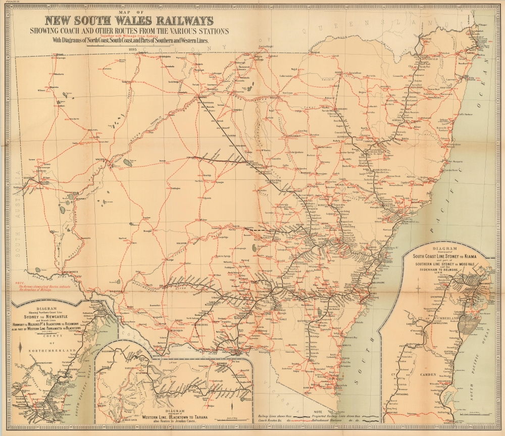
Map of New South Wales Railways Showing Coach and Other Routes From the Various Stations Together with Mileage from Sydney with Diagrams of North Coast, South Coast, and Part of Southern and Western Lines.
1895 (dated) 26 x 30 in (66.04 x 76.2 cm) 1 : 1710720
1895 (dated) 26 x 30 in (66.04 x 76.2 cm) 1 : 1710720
Description
This is an 1895 Department of Lands of New South Wales map of the railways and coach routes of New South Wales, Australia.
A Closer Look
Depicting from South Australia to the Pacific Ocean and from the Colony of Queensland to the Colony of Victoria, the focus is placed on railroad and coach routes. Solid black lines highlight railroad routes and the dashed black lines indicate projected railway lines. Coach lines appear as red dashed lines. Stops along both the railroad and coach lines are labeled and marked by circles, with the mileage from Sydney noted as well. Rivers and lakes are illustrated, including the Macintyre River and the Durmareso River along the border between New South Wales and Queensland and the Murray or Hume River which forms part of the border between Victoria and New South Wales.The Inset Maps
Three inset maps are situated along the bottom border. A map of the rail line from Sydney to Newcastle is occupies the lower left corner. Next to this map is a map of part of the western line from Blacktown to Tarana, which also includes the coach routes to the Jenolan Caves. In the lower right corner, the third inset depicts the South Coast Line from Sydney to Kiama, part of the Southern Line from Sydney to Moss Vale, and the Sydenham to Belmore Line.Publication History and Census
This map was created and published by the Department of Lands of New South Wales in 1895. We note six examples cataloged in OCLC, which are part of the collections at the State Library of New South Wales, the National Library of Australia, the University of Melbourne, the State Library of Western Australia, the Bibliothèque Nationale de France, and Brigham Young University.Condition
Good. Toning and wear along original fold lines. Verso repairs to fold separations. Closed tear extending four inches into printed area from left margin professionally repaired on verso.
References
OCLC 271786181.