1938 Fairmap Pictorial City Map or Plan of New York City
NewYorkCity-fairmap-1938$500.00

Title
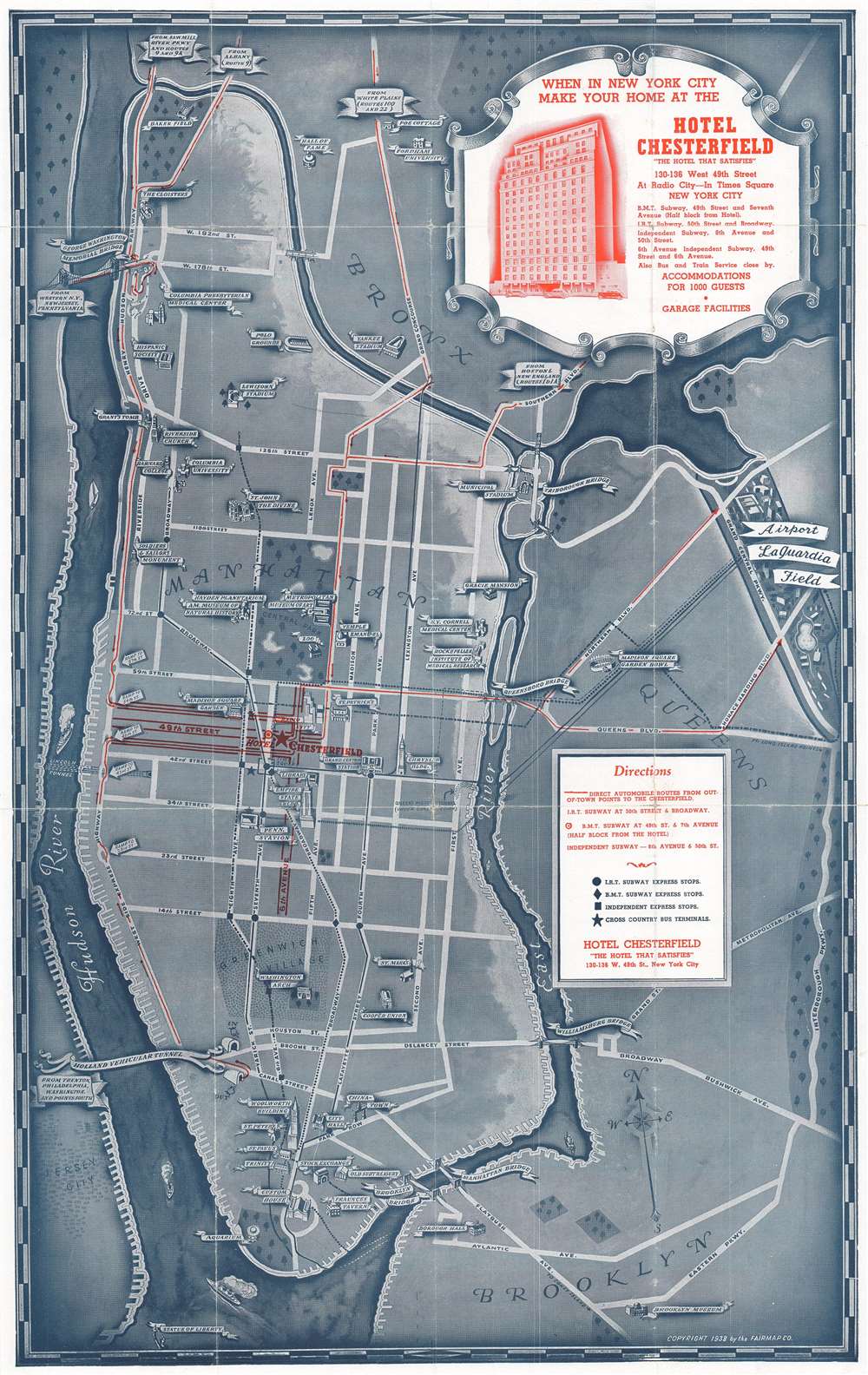
Welcome to the Wonder City of the World / Map of New York City Showing All the Principal Points of Interest to be Seen in This the Wonder City of the World - All Easily Accessible from the Hotel Chesterfield.
1938 (dated) 21.75 x 13.75 in (55.245 x 34.925 cm) 1 : 43000
1938 (dated) 21.75 x 13.75 in (55.245 x 34.925 cm) 1 : 43000
Description
This is a 1938 Fairmap Company pictorial map of New York City. The map depicts the city from the Hudson River to the Interborough Parkway between Brooklyn and Queens and from the Bronx to the Statue of Liberty. Created as a promotional advertisement for the Hotel Chesterfield, located on 49th Street near Radio City Music Hall, numerous tourist attractions and New York City landmarks are illustrated in profile and identified. Some of these include the Metropolitan Museum of Art, the American Museum of Natural History, the Empire State Building, the Chrysler Building, Radio City Music Hall, and Grand Central Station. Other New York City institutions, such as Barnard College, Columbia University, the Cooper Union, and the Fraunces Tavern are also noted. The Manhattan Bridge, Brooklyn Bridge, Williamsburg Bridge, and Triborough Bridge are all illustrated. LaGuardia Airport (then known as the New York Municipal Airport) is illustrated in Queens but was not yet open and would not open until December 2 of the following year. Major streets throughout Manhattan are illustrated and labeled, including Fifth Avenue, Park Avenue, and 14th, 34th, and 42nd Streets. Numerous routes into the city are traced in red, with their final destination being, of course, the Hotel Chesterfield. Express subway stops are also noted on the I.R.T., B.M.T., and Independent lines, although local stops are ignored.
This map was created and published by the Fairmap Company as a promotional b advertisement for the Hotel Chesterfield.
This map was created and published by the Fairmap Company as a promotional b advertisement for the Hotel Chesterfield.
Condition
Good. Wear along original fold lines. Slight loss at fold intersections. Text on verso.