1857 Phelps City Map or Plan of New York City
NewYorkCity-phelps-1857-2$1,500.00

Title
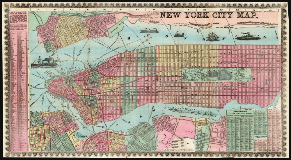
New York City Map.
1857 (dated) 16 x 29.25 in (40.64 x 74.295 cm) 1 : 22440
1857 (dated) 16 x 29.25 in (40.64 x 74.295 cm) 1 : 22440
Description
This is a detailed, colorful 1857 map of New York City by Humphrey Phelps.
A Closer Look
The map depicts Manhattan south of 131st Street as well as adjacent parts of Brooklyn, Queens, Hoboken, and Jersey City. Individual streets are named as are many individual buildings. The map notes ferry crossings, piers, and shipping lanes. Various types of sailing, cargo, and steam vessels decorate the Hudson River. Where Columbia University now stands, this map reveals a 19th century Lunatic Asylum. Central Park, though only in the planning stages when this map was published, is rendered in detail exhibiting the fully glory of Olmstead's plan, although only up to 105th Street, which was the limit of Olmstead's original plan. Here, Central Park is extended to 110th Street, with development only up to 105th, indicating that the change was recent. The city is colored by ward, and the fire districts have been illustrated, illuminating the perceived importance of fire safety. A street and avenue guide of New York City is situated along the left border, while street and avenue indexes of Brooklyn is included in the lower right.Historical Context
The mid-19th century was a dynamic period in urban development of New York City. Under the governance of Tammany Hall and the corrupt 'Boss' Tweed, New York City had become a mélange of extremes. By 1864 the Five Points had devolved into the world's most notoriously dangerous slum, while further north the high ideals and design genius of Egbert Viele, Frederick Law Olmstead, and Calvert Vaux created Central Park, the world's first and possibly finest planned public recreation area. Meanwhile, across the East River, Brooklyn, Greenpoint, and Williamsburg consolidated into a single city, becoming in the process the third largest city in the United States, and setting the stage for the emergence of the modern New York City.Publication History and Census
This map was prepared for print by Humphrey Phelps in 1857; it is well represented in institutional collections, and appears on the market from time to time.Cartographer
Humphrey Phelps (1799 - 1875) was an American map, broadside, and book publisher based in New York City. Phelps was born in 1799 in Hebron, Connecticut. Phelps' earliest work seems to be a plan of New York City for his Stranger's Guide, dating to about 1830. Between 183- and 1837 he published with Bela Scovil Squire (1786 - 1861) under the imprint of Phelps and Squire. The New York map publishing circle seems to have been quite close and Phelps commonly partnered with various other New York publishers and printers including Edward H. Ensign (1818 - 1871), Horace Thayer, Erastus Clark Bridgman (1817 - 1870), Thomas C. Fanning (1805 - 1873), Hooker, Peabody, Charles Magnus, Gaylord Watson, and George Walker, among others. The natural consequence of his rampant partnering is a vast and varied corpus of work including many scarce items with low print runs. Phelps is best known for his emigrant and tourist guides. More by this mapmaker...
Source
Phelps, H., Strangers and Citizens' Guide to New York City, (New York) 1859.
Condition
Very good. Bright original colors. Some separation at junctures of folds with no loss. Backed on archival tissue for stability.
References
OCLC 19761544. Haskell, D., Manhattan Maps: A Co-operative List, 1045.