1961 Macha Drafting Co. Map of Oil and Gas Resources in North Africa
NorthAfricaOil-macha-1961$650.00


Title
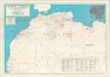
North Africa Oil and Gas Developments.
1961 (dated) 26.25 x 38 in (66.675 x 96.52 cm) 1 : 4786000
1961 (dated) 26.25 x 38 in (66.675 x 96.52 cm) 1 : 4786000
Description
An impressive large-format 1961 map of northwestern Africa highlighting the region's oil and gas resources, prepared by the Macha Drafting Co. and published as a supplement to World Oil. It was published during the closing stages of the Algerian War for Independence (1954 - 1962), as France sought to end the conflict and grant Algeria independence while maintaining its interests in Saharan oil and gas fields.
The Evian Accords, which ended the war, allowed French and other foreign oil and gas companies to maintain their interests in Algeria, though they were under continuous pressure for the following decade, until Algeria nationalized the oil and gas industries in 1972 (American firms had been effectively nationalized in 1967 due to the Six-Day War). A state-owned firm, Sonatrach (Société Nationale pour la Recherche, la Production, le Transport, la Transformation, et la Commercialisation des Hydrocarbures), took control of nearly all foreign production in Algeria and today operates a multinational oil and gas consortium, constituting some thirty percent of Algeria's gross national production. Today, Algeria remains among the top twenty oil and gas-producing countries in the world.
A Closer Look
The coast of Africa is displayed from Guinea and Portuguese Guinea in the west through Libya in the east. Oil and gas fields, wells, and pipelines are indicated according to the legend at left, along with refineries, concessions, and cities with airfields. Waterways and national boundaries are also indicated. An inset of the area displayed as part of the entire continent of Africa is presented at top-right. At bottom is a list of concessions by country or territory, noting to which company or entity the concession was granted. Curiously, the original owner of this map had made several handwritten annotations in Spanish Sahara, now the autonomous disputed territory of Western Sahara, where a decades-long conflict over the region's future has prevented large-scale oil and gas exploitation.Hydrocarbons and Algeria's War for Independence
This map was made in the context of the Algerian War of Independence (1954 - 1962). The bitterly fought insurgency, which saw the horrific war crimes committed, claimed the lives of thousands of French soldiers and pieds-noirs (European-descended Algerians) as well as over 1,000,000 Algerians. By the time this map was made, domestic and international opposition had grown to the point that France was seeking to end the conflict while maintaining some of its colonial privileges. In a January 8, 1961, referendum, voters overwhelmingly approved Algerian independence. A failed putsch among pro-colonial French generals in April further weakened France's position. President Charles de Gaulle agreed to grant coastal regions of Algeria independence but tried to maintain French control over the oil and gas-rich Sahara, explaining its unusual demarcation from the rest of Algeria here. But continued resistance from the Front de libération nationale (FLN), the main independence force in Algeria, and further bungled plots by pro-colonial forces in France's military and intelligence services, turned public opinion even further against the war, forcing de Gaulle to agree to grant independence to all of Algeria in February-March 1962.The Evian Accords, which ended the war, allowed French and other foreign oil and gas companies to maintain their interests in Algeria, though they were under continuous pressure for the following decade, until Algeria nationalized the oil and gas industries in 1972 (American firms had been effectively nationalized in 1967 due to the Six-Day War). A state-owned firm, Sonatrach (Société Nationale pour la Recherche, la Production, le Transport, la Transformation, et la Commercialisation des Hydrocarbures), took control of nearly all foreign production in Algeria and today operates a multinational oil and gas consortium, constituting some thirty percent of Algeria's gross national production. Today, Algeria remains among the top twenty oil and gas-producing countries in the world.
Publication History and Census
This map was prepared by the Macha Drafting Company as a supplement to the January 1961 edition of World Oil, published by the Gulf Publishing Company. It is recorded in the OCLC among the holdings of some fifteen institutions worldwide.CartographerS
Macha Drafting Company (c. 1952 - 1961) was a short-lived cartographic firm based in Houston, Texas. It mostly focused on producing maps of various Texas counties, but also prepared maps related to the oil industry for World Oil and Fortune magazines. More by this mapmaker...
Gulf Publishing Co. (1916 - present), based in Houston, Texas, is a leading publisher of magazines and books related to the oil and gas industry. Founded in 1916 by teacher and journalist Ray Lofton Dudley, its monthly publications now include World Oil, Hydrocarbon Processing, Pipeline and Gas Journal, and the Petroleum Economist, all of which are highly influential and widely read by industry specialists. The firm has changed somewhat over the years, operating as a subsidiary of Euromoney Institutional Investor from 2001 until a 2016 and spinning off parts of the business, such as book publishing. It rebranded in 2018 as Gulf Energy Information, but its core function as one of the world's leading sources of specialized information on the energy industry remains. Learn More...
Source
Supplement to World Oil, Jan. 1961 (Houston, TX: Gulf Publishing Co. ).
Condition
Good. Wear along original folds. Light discoloration along some folds. Some pen and pencil annotations.
References
OCLC 10361325, 255295402, 315811688.