1804 Reichard Map of North America w/ state of Franklinia

NorthAmerica-reichard-1804-2
$1,850.00
Charte von Nord America nach en neuesten Bestimmungen und Entdeckungen. - Main View
Processing...

1804 Reichard Map of North America w/ state of Franklinia

NorthAmerica-reichard-1804-2

Ephemeral state of Franklin!
$1,850.00

Title


Charte von Nord America nach en neuesten Bestimmungen und Entdeckungen.
  1804 (dated)     24 x 21 in (60.96 x 53.34 cm)     1 : 13000000

Description


A fascinating 1804 map of North America by C. G. Reichard including the ephemeral 'lost state' of Franklin. The map embraces all of North America from Baffin Bay and Cook's Inlet (Alaska) to Panama and the Spanish Main, including all of the modern-day United States, Canada, Mexico, West Indies, and Central America.
The State of Franklin
This map's most intriguing aspect is the inclusion of the State of Franklin. Also known as the Frankland or Franklinia, Franklin was a proto-state named after Benjamin Franklin and founded by settlers in what was then western North Carolina. It is unique in that it originated in both a cession and secession. Franklin emerged from land in western North Carolina ceded to the federal government to pay war debts. The region was remote, and settlers rightly complained that their interests were sidelined by both North Carolina and the federal government. In the hope of greater representation, the Franklinites, as they became known, seceded from North Carolina in 1784 and applied for independent statehood. Despite two attempts with Congress, Franklin was never recognized. For a time, still at odds with North Carolina over taxation, protection, and other issues, Franklin began operating as a de facto independent republic. After four years of turmoil, indecision, increasing debt, and dismissal by Congress, the area was reabsorbed by North Carolina in 1788. Shortly thereafter it become a part of Tennessee, which itself became a state in 1796.
But Why is Franklin in West Virginia?
This map is unique in that it records Franklin in what is today West Virginia, rather than the proto-state's usual boundaries in western North Carolina. This is not merely a cartographic error but has some basis in fact:
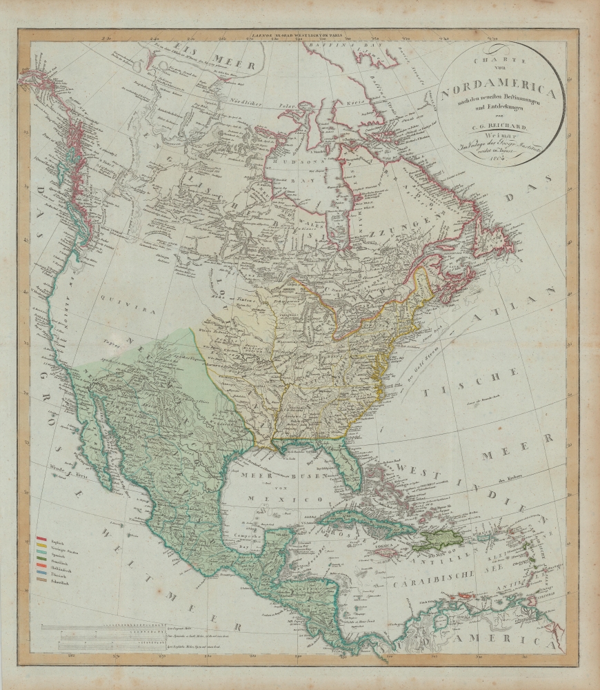
In 1783 a meeting was held at Abingdon, Virginia, over which the Rev. Charles Cummings presided and Col. Arthur Campbell was a leading spirit. This meeting addressed a memorial to Congress asking that a new state, to have the name Frankland, be erected. The boundaries of the proposed state, as set out in this memorial and more fully in a message of Governor Patrick Henry to the Virginia Legislature, embraced most of Southwest Virginia, the southeastern part of Kentucky, the eastern half of Tennessee, parts of Alabama and Georgia, and all of what is now Mercer County, West Virginia and a part of Summers County.

Virginia very promptly squelched this effort to form a new state out of her territory. North Carolina, however, struggled from 1784 to 1788 with her portion (now Eastern Tenn.) which during that time maintained a government calling itself the State of Franklin. Biennial Report of the Department of Archives and History of the State of West Virginia, 1914, page 15-16.
Louisiana Purchase Defined
Reichard issued this map shortly after the 1803 Louisiana Purchase - and Louisiana is thusly separated as a distinct area between the Mississippi River and Arkansas River. A second segregated area stands between the Arkansas and Sabine River, underscoring the ambiguity over the full extent of 'Louisiana.' The United States maintained the claim of France that Louisiana included the Mississippi River and 'all lands whose waters flow to it'. To the west of New Orleans, the United States assumed the French claim extended as far as the Sabine River. Spain, conversely, maintained that all land west of the Calcasieu River and south of the Arkansas River belonged to Tejas and Santa Fe de Nuevo México. The dispute was resolved in the 1819 Adams-Onis Treaty.
Curious Treatment of the Missouri River
Reichard offers a most curious treatment of the Missouri River - especially when considering that when this map was engraved, the Lewis and Clark Expedition (1804 - 1806) was still underway. Here the Missouri runs northwest from St Louis until fading into the unknown - a point defined by the river transitioning from a solid to a dotted line. The Missouri reappears as a solid line in the vicinity of the Mandan Villages - where, as this map went to press, Lewis and Clark were wintering. The Mandan were visited several times prior, most recently by British and French fur traders, and in 1796 by the explorer John Evans (1770 - 1799), who hoped to find proof the Mandan language was related to Welsh (it's not).
Publication History and Census
This map was drawn and compiled by Christian Gottleib Reichard and published in Weimar by Geographischen Institutes Weimar. It appears in several editions, but only this, the first edition, featured the State of Franklin. A second edition, issued in the same year, removed Franklin entirely. Over all editions, the map is well represented institutionally, but due to inconsistent cataloging, it impossible to determine first editions vs. more common latter editions.

CartographerS


Christian Gottleib Reichard (June 6, 1758 - September 11, 1837) was a Weimar based German cartographer active in the late 18th and early 19th centuries. He was educated at the Lyceum of Schleiz and studied law at the University of Leipzig. Reichard developed an early interest in geography, drawing, and music, which he continued to develop throughout his life. His first cartographic project was a globe made for his children, which attracted the interest Baron Franz Xaver von Zach in Gotha. With Zach's support Reichard delved more fully into cartography, publishing several important works early in the 19th century focusing on the discoveries of Mungo Parke, Rennel, Lander, and Alexander von Humboldt. He also supplied several charts to the Homann Heirs firm. Along with Adolf Stieler and the Perthes publishing companies, he collaborated on the first Stieler's Handlatlas. Published between 1817 and 1823, the first Stieler's Handlatlas proved to be a long lived and influential work that continued to be revised and updated well into the 20th century. In addition, he also published several general and historical atlases on his own account between 1803 and 1824. More by this mapmaker...


Geographisches Institut, Weimar (fl. 1804 - c. 1903) was a German map and globe publishing house and geographical research institute based in Weimar. The organization primarily focused on republishing and improving upon the works of earlier cartographers, including Kitchin, Jefferys, Carey, and others. In general, its publications are known for their fine engraving, attention to detail, historical accuracy, and overall high quality. The firm was founded in 1804 by Friedrich Justin Bertuch (???? - c. 1845) and, on his death, passed to his son Robert Froreip (???? - 1855), then to Louis Denicks of Luneberg, then in 1859 to Voigt & Günther, in 1883 to F. Arnd, from 1890 - 1893 to Julius Kettler, and in 1903 to Max Wedekind. During the institute's height in the early 19th century, most of its cartographic publication was overseen by Carl Ferdinand Weiland (1782 - 1847). The firm also employed the cartographers Franz Xaver von Zach, Adam Christian Gaspari, Heinrich Kiepert, Karl (or Carl) and Adolf Graef, Julius Kettler, Carl Riemer and Karl Christian Bruhns. Weimar was a logical place for a collective like the Geographisches Institut to arise; it was a cultural mecca in the German-speaking world in the late 18th and 19th centuries because of its liberal atmosphere and associations with figures like Schiller, Herder, and, above all, Goethe, who spent most of his adult life in the city. Learn More...

Source


Reichard, C. G., Allgemeiner Hand-Atlas der Ganzen Erde, (Weimar: Geographischen Institutes Weimar) 1804.    

Condition


Very good. Wear on old fold.

References


OCLC 42207337, 41589584.