1851 Tallis Map of North America, Retaining Pre-1848 Borders
NorthAmerica-tallis-1851$400.00

Title
North America.
1851 (undated) 14 x 9.5 in (35.56 x 24.13 cm) 1 : 35000000
1851 (undated) 14 x 9.5 in (35.56 x 24.13 cm) 1 : 35000000
Description
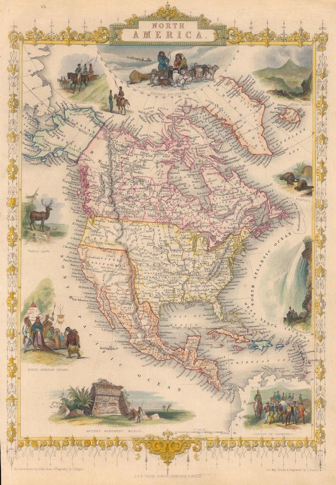
This is John Tallis's c. 1851 map of North America, drawn and engraved by John Rapkin. It is most notable for including an ephemeral depiction of the borders of North America in the wake of the Mexican-American War (1846 - 1848), though not entirely reflecting the changes brought about by the 1848 Treaty of Guadalupe Hidalgo, perhaps a veiled criticism of the new territorial acquisitions of the United States.
Other areas of interest include a large 'Western Territory' north of Texas, a New Mexico Territory in the Texas Panhandle (see below), and a sprawling Nebraska Territory extending from the Kansas River to the Canadian Border but truncated on the west by the Missouri River. West of Nebraska, Tallis presents a large Missouri Territory extending to the Oregon Territory.
Cities, rivers, islands, forts, coastal capes, and other features are labeled throughout, while major mountain chains are illustrated. Central America is nearly an afterthought, being traced and shaded as if it were a part of Mexico. Around the map are several beautiful vignettes depicting 'North American Indians,' a 'White Deer,' 'Beavers,' the 'Falls of Niagara,' a 'Convoy of Diamonds,' an 'Ancient Monument, Mexico,' 'Cossacks,' and the 'Esquimaux Dog-Sledge.'
A Closer Look
Coverage extends from the Arctic to the northern portion of South America, focusing on British America (Canada), the United States of America, and Mexico. Perhaps the most immediately recognizable element of the map is the retention of Upper California as part of Mexico, a seemingly intentional anachronism by Tallis, possibly reflecting his views on the justifiability of American territorial expansion after the Mexican-American War. Compared to an earlier edition of the map, previously sold by us and dated (from context) to 1850, several changes are apparent, such as the renaming of California's Buenaventura River as the Sacramento River and the borders of the Oregon Territory reflecting the 1846 Treaty of Oregon. Curiously, the mapping of the California coastline, and especially the San Francisco Bay, remains inaccurate, and San Francisco is not included, despite global fascination with the California Gold Rush.Other areas of interest include a large 'Western Territory' north of Texas, a New Mexico Territory in the Texas Panhandle (see below), and a sprawling Nebraska Territory extending from the Kansas River to the Canadian Border but truncated on the west by the Missouri River. West of Nebraska, Tallis presents a large Missouri Territory extending to the Oregon Territory.
Cities, rivers, islands, forts, coastal capes, and other features are labeled throughout, while major mountain chains are illustrated. Central America is nearly an afterthought, being traced and shaded as if it were a part of Mexico. Around the map are several beautiful vignettes depicting 'North American Indians,' a 'White Deer,' 'Beavers,' the 'Falls of Niagara,' a 'Convoy of Diamonds,' an 'Ancient Monument, Mexico,' 'Cossacks,' and the 'Esquimaux Dog-Sledge.'
A Curious Configuration of Western Geography
One of the more interesting features of this map is undoubtedly the Texas, New Mexico, and Western Territory political configuration, which when Rapkin drew this map remain unsettled. In the earliest edition of this map (published in early 1850), the area that is here New Mexico was part of the original Texas annexation. The Texas border presented here roughly follows the February 1850 proposal of Whig Senator Henry Clay, who recommended that, in exchange for federal assumption of its war debt, Texas surrender all lands north of the 32nd parallel and west of the 103rd Meridian. Those lands to the west of the 103rd Meridian would become New Mexico, while those to the north of the 32nd parallel, would be an unorganized territory which Tallis has here dubbed 'Western Territory.' Henry Clay's proposal was not fully adopted; however, it did have an impact on the final compromise passed in September of 1850 (one part of the wider Compromise of 1850).Publication History and Census
This map was drawn and engraved by John Rapkin and published by John Tallis. The David Rumsey Historical Map Collection notes it as part of the 1851 edition of Tallis' The Illustrated Atlas, and Modern History of the World… Certain details on the map would support this conclusion, such as the inclusion of the Minnesota Territory. The map of the United States from the 1851 edition of the atlas also matches the geographical configuration seen here, with a large 'Western Territory,' New Mexico Territory in the Texas Panhandle, and a tall Nebraska Territory extending to the Canadian border. Therefore, this map must have been prepared in late 1850 or early 1851 and published in 1851. Likely, Tallis deliberately chose not to include the territorial changes relating to the Treaty of Guadalupe Hidalgo (signed February 1848). Although Tallis' intent in doing so is unclear, it may have been to express disapproval.CartographerS
John Tallis and Company (1838 - 1851) published views, maps, and atlases in London from roughly 1838 to 1851. Their principal works, expanding upon the earlier maps of John Cary and Aaron Arrowsmith, include an 1838 collection of London Street Views and the 1849 Illustrated Atlas of the World. The firm’s primary engraver was John Rapkin, whose name and decorative vignettes appear on most Tallis maps. Due to the embellishments typical of Rapkin's work, many regard Tallis maps as the last bastion of English decorative cartography in the 19th century. Although most Tallis maps were originally issued uncolored, it was not uncommon for 19th century libraries to commission colorists to "complete" the atlas. The London Printing and Publishing Company of London and New York bought the rights for many Tallis maps in 1850 and continued issuing his Illustrated Atlas of the World until the mid-1850s. Specific Tallis maps later appeared in innumerable mid to late-19th century publications as illustrations and appendices. More by this mapmaker...
John Rapkin (July 18, 1813 - June 20, 1899) was an English mapmaker and engraver. Born in Southwark, Rapkin was the son of George Rapkin, a shoemaker, and his wife Elizabeth Harfy. Rapkin and his brother Richard both became engravers and his other brother, William Harfy Rapkin, became a copperplate printer. Rapkin produced works for James Wyld and John Tallis, including The United States and the relative position of Oregon and Texas for Wyld around 1845, and a series of eighty maps for Tallis that became 'Tallis's illustrated atlas, and modern history of the world' in 1851. Rapkin married Frances Wilmot Rudell on January 4, 1837, with whom he had at least eight children, some of whom became engravers, including his sons John Benjamin Rapkin (1837 - 1914), Alfred Thomas Rapkin (1841 - 1905), Joseph Clarke Rapkin (1846? - 1912), and Frederick William Rapkin (1859 - 1945). Rapkin operated under the imprint 'John Rapkin and Sons from 1867 until 1883, and was operating as 'John Rapkin and Sons' by 1887. Rapkin died in 1899 at the age of 85 soon after the death of his wife of over sixty years. Learn More...
J Marchant (fl. c. 1825 - 1869) was a British illustrator and cartographer whose most prominent work was in the variosu editions of Tallis's Illustrated Atlas and Modern History of the World. Learn More...
Condition
Very good. Edge trimmed somewhat unevenly, with some wear and toning at right. Small are of loss in top-left corner.
References
Rumsey 0466.065. OCLC 50446876 (co-mingles digital and physical examples).