
This item below is out of stock, but another example (left) is available. To view the available item, click "Details."
Details
1762 Janvier Map of North America (Sea of the West, First Edition)
$900.00
1762 Janvier Map of North America (Sea of the West, First Edition)
NorthAmerica4-janvier-1762$400.00

Title
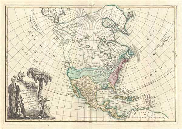
L'Amerique Septentrionale Divisee en ses Principaux Etats.
1762 (dated) 12.5 x 18 in (31.75 x 45.72 cm) 1 : 32000000
1762 (dated) 12.5 x 18 in (31.75 x 45.72 cm) 1 : 32000000
Description
An altogether fascinating first edition example of Jean Janvier 1762 map of North America, including one of the most ambitions depictions of the Sea of the West in any map. The map covers the continent from Panama to the Arctic Circle, extends westward to include parts of Asia and eastward as far as Iceland. This map, which is heavily influenced by the theoretical mappings of Guillaume de l'Isle and Philippe Buache, went through several states of which this is the first and possibly the most interesting. Javier divides the continent according to the three colonial powers that controlled it, with England controlling the colonies along the east coast, France occupying Canada and Louisiana, and Spain dominating Mexico, Florida, Cuba and Central America.
Drawn by Jean Janvier for issue as plate no. 32 in Jean Lattre's 1762 first edition issue of the Atlas Moderne.
Sea of the West
By far the most interesting aspects of this map deal with Janvier's treatment of the largely unexplored Pacific Northwest. A magnificent sea, called the Sea of the West or in this case the 'Baye de L'Ouest,' occupies the greater part of the northwestern part of the continent. This body of water, alternatively called the 'Sea of the West' or 'Mer de l'Ouest', was speculated by Philippe Buache and Guillaume De l'Isle in the early 18th century based upon wishful thinking, American Indian stories, and the somewhat questionable 16th century explorations of Juan de Fuca. Janvier gives the Mer de l'Ouest its fullest expression, although he specifically does not connect it to either the network of lakes and rivers extending westward form the Hudson Bay or to the similar network extending westward from Lake Superior.Discoveries of the Coureurs des Bois
These river and lake networks were being actively explored throughout the early 18th century by a number of little known but important French explorers. Most specifically the explorations of the La Vérendrye brothers and other coureurs des bois, with regard to the discovery of the Lake of the Woods (L. Des Bois) and Lake Winnipeg (L. Ouinipigon), both of which appear on this map. However, despite the activity of French explorers and fur traders in this region, the entire upper of the continent northwards of the Mississippi River watershed and the St. Lawrence River is not territorially assigned to any European Power. This little explored region was then subject to questionable colonial jurisdiction. The French claimed all of modern-day Canada while at the same time this region was in its entirety part of the Hudson Bay Company's royal charter. Legally this would be come much clearer in the year after this map was issued. In 1863, following the Seven Years War, France ceded nearly all of its North American territory to England. Nonetheless, this poorly policed and vast land remained hotly contested on the practical level as traders fur traders, backwoodsmen, and coureurs des bois flooded the wilderness in search of its most treasured commodity, beaver pelts.The Apocryphal Admiral de Fonte
Further north we can find traces of Admiral de Fonte's apocryphal discovery of a passage from the Pacific (starting at the Archipel St. Lazare) eastward via a network of lakes and rivers to Baffin Bay. The De Fonte legend first appeared in a 1706 english publication entitled Memoirs of the Curious. This short-lived magazine published a previously unknown account by a supposed Spanish Admiral named Bartholomew de Fonte. De Fonte is said to have sailed up the Pacific coast of North America in 1640. On this voyage he apparently discovered a series of gigantic lakes, seas, and rivers heading eastward from the Pacific towards Hudson Bay. The De Fonte story relates how, on one of these great inland lakes, he met with a westward bound ship from Boston that must to have come through the Northwest Passage. Today, based upon inaccuracies and falsities, we know the entire De Fonte article to have been a fabrication, however, it set 18th century afire with speculation that a Northwest Passage must indeed exist. even such luminaries as Benjamin Franklin wrote long defenses of De Fonte. Our map offers an uncommon variant on the De Fonte passage, positioning its western entrada well to the north in order to accommodate the Sea of the West and situating its outlet at the Baffin rather than the Hudson Bay.Bering and Proto-Alaska
Even farther to the north we find the Strait of Anian narrowly separating American from Asia. The extreme northeast tip of Asia is itself fairly well mapped giving evidence to the explorations of Vitus Bering and Tschirikow. Slightly to the south of Asia the cartography is slightly less certain with regard to a questionable landmass in the north Pacific. This mass most likely stems from Tschirikow sightings of the Aleutian Islands and the assumption by Muller and others that they may have been a single land mass.The Great Lakes
On the opposite side of the map, Janvier places the Great Lakes firmly within French territory, a clear case of carto-advocacy. The English colonies, outlined in red are only vaguely accurate with regard to their borders with Pennsylvania and New Jersey extending north to the Canadian border.Publication History and Census
The lower left hand quadrant is dominated by a large decorative title cartouche depicting some of the flora of the continent. Though most examples of this map are dated 1762, the map itself appeared in multiple states between its first edition in 1762 and final iteration in the late 1780s. We have identified at least four variants. The first edition, 1762, includes a large 'Sea of the West', a series of lakes and rivers associated with the legendary voyages of Admiral de Fonte, and the Aleutians rendered as a single landmass, a la Muller. A second variant, possibly 1775, includes the De Fonte speculation, and the 'Lake of the West', but renderers the Aleutians embryonically as a series of islands. Another third state, possibly from 1782, retains the 'Sea of the West', but does not include the De Fonte discoveries further north, and the Aleutians are embryonically rendered as individual islands. There may be still other variations we have yet to discover, including a 1771 issue and a 1783 issue illustrating a post-Revolutionary War Untied States. A full series of these beautifully produced maps presents a thorough overview of the conceptual development of the American northwest prior to Cook.Drawn by Jean Janvier for issue as plate no. 32 in Jean Lattre's 1762 first edition issue of the Atlas Moderne.
CartographerS
Jean Denis Janvier (fl. 1746 - 1776), sometime also known as 'Robert', was a Paris based cartographer active in the mid to late 18th century. Janvier signed his maps Signor Janvier. By the late 18th century, Janvier was awarded the title of 'Geographe Avec Privilege du Roi' and this designation appears on many of his later maps. Janvier worked with many of the most prominent French, English and Italian map publishers of his day, including Longchamps, Faden, Lattre, Bonne, Santini, Zannoni, Delamarche, and Desnos. More by this mapmaker...
Jean Lattré (170x - 178x) was a Paris based bookseller, engraver, globe maker, calligrapher, and map publisher active in the mid to late 18th century. Lattré published a large corpus of maps, globes, and atlases in conjunction with a number of other important French cartographic figures, including Janvier, Zannoni, Bonne and Delamarche. He is also known to have worked with other European cartographers such as William Faden of London and the Italian cartographer Santini. Map piracy and copyright violations were common in 18th century France. Paris court records indicate that Lattré brought charges against several other period map publishers, including fellow Frenchman Desnos and the Italian map engraver Zannoni, both of whom he accused of copying his work. Lattré likes trained his wife Madame Lattré (né Vérard), as an engraver, as a late 18th century trade card promotes the world of 'Lattré et son Epouse.' Lattré's offices and bookshop were located at 20 rue St. Jaques, Paris, France. Later in life he relocated to Bordeaux. Learn More...
Source
Lattre, Jean, Atlas Moderne ou Collection de Cartes sur Toutes les Parties du Globe Terrestre, (Paris) 1762.
Condition
Very good condition. Original centerfold. Blank on verso.
References
Phillips (Atlases) 629-33. Wagner, H. R., The Cartography of the Northwest Coast of America to the Year 1800, 559. Wheat, C. I., Mapping of the Transmississippi West, 1540 - 1861, 192. Sellers, J. R. and Van Ee, P. M., Maps and Charts of North America and the West Indies 1570-1789, 93. McGuirk, D., The Last Great Cartographic Myth: Mer de l'Ouest, no. 109. Lowery, W., The Lowery Collection: A Descriptive list of Maps of the Spanish Possessions within th present limits of the United States, 1502 - 1820, 663. Sellers J., and Van Ee, P., Maps and Charts of North America and th West Indies, 1750 - 1789, 93.