1947 Clegg Pictorial Map of Northern Ireland
NorthernIreland-clegg-1947$250.00

Title
Northern Ireland.
1947 (dated) 16.75 x 21.75 in (42.545 x 55.245 cm) 1 : 500000
1947 (dated) 16.75 x 21.75 in (42.545 x 55.245 cm) 1 : 500000
Description
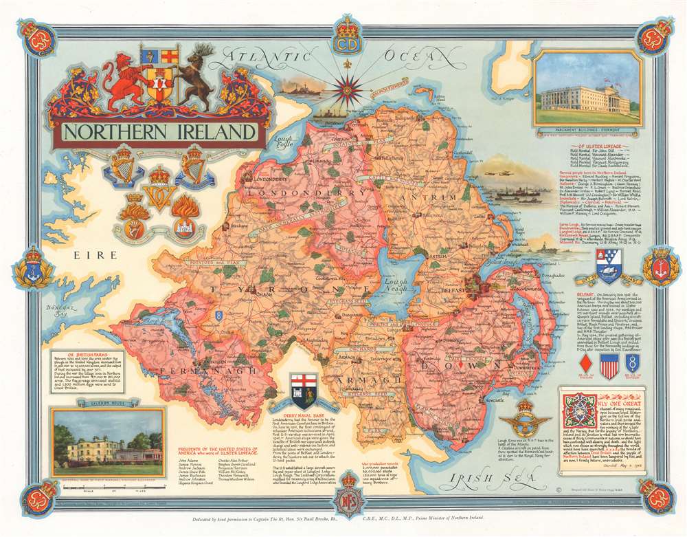
Published immediately after World War II, this is a 1947 Ernest Clegg pictorial map of Northern Ireland. The map celebrates Northern Ireland's role in securing an Allied victory in Europe during World War II.
A Detailed Look at the Map
Northern Ireland's six counties are identified by block lettering and shaded different colors to allow for easy differentiation. Lough Neagh, Lough Foyle, and Lough Erne are present as well. Banners bearing red block lettering proclaims each region's agricultural products (and, by extension, their agricultural contribution to the war effort), including oats, potatoes, flax, orchards, cattle, and poultry. Cities and towns throughout Northern Ireland are labeled, including Belfast, Bangor, Londonderry, and Omagh, and Enniskillen, which are all highlighted by pictorial icons.The Map, Northern Ireland, and World War II
Pictorial vignettes illustrate warships and merchant ships in the seas off the Northern Irish coast, including part of the armada participating in the D-Day invasion of Normandy. Blocks of text situated along the border promote Northern Ireland's war-time contributions, including the importance of the Londonderry Naval Base, Belfast's harbor and shipyards, and of Royal Air Force (R.A.F.) bases. A quote from Sir Winston Churchill, dated May 6, 1943, credits Northern Ireland with being critical to the perseverance of the British people and their ultimate victory. A view situated in the upper right corner illustrates the Parliament Buildings, which housed R.A.F. Headquarters in Northern Ireland from October 1942 until February 1945. The other view, which adorns the lower left corner, depicts Caledon House, the ancestral home of Field Marshal Viscount Alexander. The insignia of five important Northern Irish units adorn the upper left corner as part of the decorative title cartouche.Publication History and Census
This map was designed and drawn by Ernest Clegg, devised by Donald McCullogh, and reproduced and printed by John Waddington, Limited, in 1947. Five examples are cataloged in OCLC and are part of the institutional examples at the Library of Congress, the National Library of Scotland, the University of Cambridge, Stanford University, and the Biblioteca Comunale di Trento in Trento, Italy. An example is part of the David Rumsey Map Collection.Cartographer
Ernest Clegg (1876 - December 7, 1954) was a British cartographer, graphic artist, and calligrapher. Born in the Birmingham suburbs in 1876, Clegg attended grammar school before gaining acceptance into the Birmingham School of Art. Clegg, who established himself as a specialist calligrapher during these years, was greatly influenced by the Victorian Arts and Crafts Movement and drew inspiration from illuminated manuscripts created during the medieval period. He joined the 7th Dragoon Guards at the outbreak of the Boer War in 1899, and took part in the British advance into the Orange River Colony and Transvaal as part of the 4th Cavalry Brigade in 1900-1901. Clegg was wounded in 1901 and sent back to Britain, and, following his recovery, he enlisted in the newly-formed South African Constabulary. He was posted to the South African Constabulary's sub-divisional headquarters in Harrismith, Transvaal, in 1902. After a year he was transferred to the offices of the District Engineer of Railways in Harrismith, a post he held for six months. Clegg returned to Birmingham in 1905 and went to work for Tiffany in New York as a jewelry designer in 1909. After the outbreak of World War I, Clegg returned to England and received a commission in the 7th (Service) Battalion, known as The Bedfordshire Regiment ("The Shiny 7th"). He served on the Western Front from early 1915 and was promoted to Major in early 1916. While visiting the HMS Revenge, Clegg became the only British Army officer to witness first-hand the pivotal naval Battle of Jutland. He returned to the Front and was badly wounded in a German artillery barrage in late June 1916, just days before the Battle of the Somme. He had recovered and returned to France by early 1917. By the end of the war, however, Clegg had served in several different Home postings, perhaps an indication of physical and psychological scars suffered during his time in France. After his return to the United States in 1919, Clegg became a well-known figure in the American and British veteran community in New York and soon began attracting clients for his work. He illustrated a limited edition of Canadian war poet John McCrae's In Flanders Fields in 1921 and by the mid-20s was gaining recognition for his decorative illustrations and cartographic work. Clegg created a pictorial map of Charles Lindbergh's historic flight across the Atlantic, and also issued maps for the Americas Cup in 1930, 1934, and 1937, which took place off Newport, Rhode Island. Clegg stayed in New York during most of World War II, but returned to England in late 1944, supposedly as a personal favor to the British Ambassador in Washington, Lord Halifax. He soon began working on a series of pictorial maps of English Counties meant to raise money for the Women's Land Army Benevolent Fund. For unknown reasons, possibly due to post-war shortages of paper, the full series of these maps was never published. Clegg's wife, the Australian actress Rita Holden Macdonnell, whom he married in 1911, passed away in 1949. He never fully recovered after her death, and died in a nursing home in Paignton on December 7, 1954. More by this mapmaker...
Condition
Very good.
References
David Rumsey Map Collection, 8090.000. OCLC 707400394.