1891 Rand McNally Railroad Map of the Western United States
NorthernPacificRR-randmcnally-1891$750.00

Title
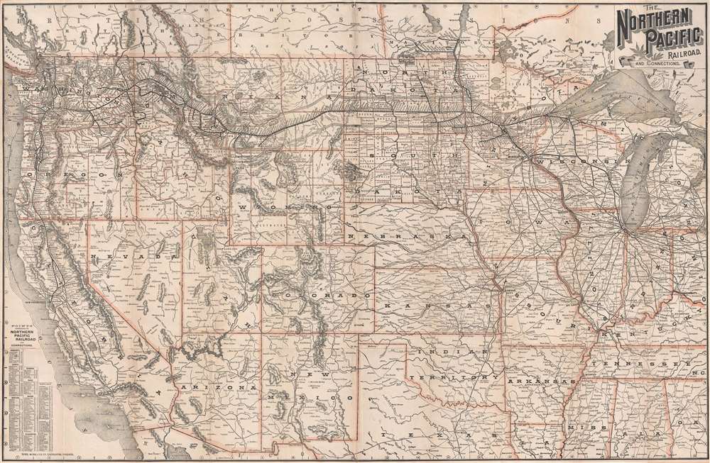
The Northern Pacific Railroad and Connections.
1891 (undated) 22.75 x 35 in (57.785 x 88.9 cm) 1 : 4300000
1891 (undated) 22.75 x 35 in (57.785 x 88.9 cm) 1 : 4300000
Description
This is an 1891 Rand McNally map of the western United States highlighting the route of the Northern Pacific Railroad. The map depicts the region from the Pacific Ocean to Detroit, Michigan and from Canada to Texas, Louisiana, and northern Mexico. Highly detailed, myriad cities, towns, and villages throughout the western U.S. are identified, including every stop along the Northern Pacific Railroad's route. Apart from the Northern Pacific, the extensive rail network that crisscrossed the western U.S. are illustrated and most of the major lines labeled. The rail hub at Chicago, for instance, is clearly visible, with a mind-boggling number of rail lines entering and leaving the city in all directions, except into Lake Michigan of course. Rivers, lakes, and mountains are also identified. Other famous locations throughout the West are noted as well, including the Grand Canyon, Yellowstone, and the Black Hills.
This map was created and published by Rand McNally in 1891.
This map was created and published by Rand McNally in 1891.
Cartographer
Rand, McNally and Co. (fl. 1856 - present) is an American publisher of maps, atlases and globes. The company was founded in 1856 when William H. Rand, a native of Quincy, Massachusetts, opened a print shop in Chicago. Rand hired the recent Irish immigrant Andrew McNally to assist in the shop giving him a wage of 9 USD per week. The duo landed several important contracts, including the Tribune's (later renamed the Chicago Tribune) printing operation. In 1872, Rand McNally produced its first map, a railroad guide, using a new cost effective printing technique known as wax process engraving. As Chicago developed as a railway hub, the Rand firm, now incorporated as Rand McNally, began producing a wide array of railroad maps and guides. Over time, the firm expanded into atlases, globes, educational material, and general literature. By embracing the wax engraving process, Rand McNally was able to dominate the map and atlas market, pushing more traditional American lithographic publishers like Colton, Johnson, and Mitchell out of business. Eventually Rand McNally opened an annex office in New York City headed by Caleb S. Hammond, whose name is today synonymous with maps and atlases, and who later started his own map company, C. S. Hammond & Co. Both firms remain in business. More by this mapmaker...
Condition
Very good. Backed on archival tissue for stability. Blank on verso.
References
OCLC 71436959.