1729 Homann Map of Akershus, (near Oslo), Norway

Norway-homann-1729
$600.00
Tractus Norvegiae Danicus Magnam Dioeceseos Aggerhusiensis. - Main View
Processing...

1729 Homann Map of Akershus, (near Oslo), Norway

Norway-homann-1729

Remarkable mining imagery.
$600.00

Title


Tractus Norvegiae Danicus Magnam Dioeceseos Aggerhusiensis.
  1729 (dated)     18.5 x 21.75 in (46.99 x 55.245 cm)     1 : 452000

Description


Here is Johann Baptist Homann's 1729 map of the county of Akershus, surrounding Oslo (Christiana), Norway. Aside from its geographic detail, it is distinguished by a large, intricate mining vignette at right - a fascinating insight into 18th-century European mine engineering.
Mining
The large vignette at right stands out prominently, portraying human and animal labor, as well as the remarkable engineering of Norwegian iron mines. Mining, especially for iron, flourished in this region in the 17th century, stretching to the west beyond the scope of this map through to Eidsvoll (here as Edsvolde), northeast of Oslo. Although operated by private interests, the state was eager to support and oversee mining given its importance for currency and military hardware. The image, presenting an cross-cut view of the inside working of a mine, is considered one of the best mining images of the early 18th century.
Great Northern War
This map was made in the immediate wake of the Great Northern War (1700 - 1721), a long and complicated conflict that saw Denmark-Norway first invade and then be invaded by Sweden. Some territory changed hands, but the most important outcome was the 1718 death of King Charles XII of Sweden, the central figure in the war, while besieging the Norwegian fortress of Fredriksten. Similar to Napoleon a century later, Charles attempted to seize Moscow but the campaign ended in disaster in 1709, leading to his exile in the Ottoman Empire. He then returned to Sweden and tried to quickly attack Denmark-Norway and force a treaty before turning towards his main enemy, Russia. It was during this campaign that he was killed at Fredriksten.
Publication History and Census
This map is dated 1729 and attributed to Johann Baptist Homann and includes the imprimatur ('cum privilegio') of the Holy Roman Emperor. However, by this time Johann had already died and the company had passed into the hands of his son Johann Christoph Homann, who himself would die the following year, after which 'Homann Heirs' became common on the firm's maps. This map first appeared in the Grosser Atlas über die ganze Welt and was reissued by Homann Heirs several times thereafter, including in 1745 for Atlas novus terrarum orbis, until the end of the century (as in Rumsey 9753.057). The large number of WorldCat entries and the comingling of digital and physical examples in catalog listings makes an accurate census difficult, but the map looks to be cataloged in the holdings of about twenty institutions, while the Grosser Atlas is more widely distributed.

Cartographer


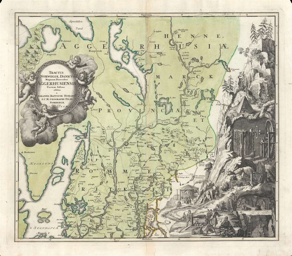
Johann Baptist Homann (March 20, 1664 - July 1, 1724) was the most prominent and prolific map publisher of the 18th century. Homann was born in Oberkammlach, a small town near Kammlach, Bavaria, Germany. As a young man, Homann studied in a Jesuit school and nursed ambitions of becoming a Dominican priest before converting to Protestantism in 1687. Following his conversion, Homann moved to Nuremberg and found employment as a notary. Around 1693, Homann briefly relocated to Vienna, where he lived and studied printing and copper plate engraving until 1695. Afterward, he returned to Nuremberg, where, in 1702, he founded the commercial publishing firm that would bear his name. In the next five years, Homann produced hundreds of maps and developed a distinctive style characterized by heavy detailed engraving, elaborate allegorical cartouche work, and vivid hand color. Due to the lower cost of printing in Germany, the Homann firm could undercut the dominant French and Dutch publishing houses while matching their diversity and quality. By 1715, Homann's rising star caught the attention of the Holy Roman Emperor Charles VI, who appointed him Imperial Cartographer. In the same year, he was also appointed a member of the Royal Academy of Sciences in Berlin. Homann's prestigious title came with several significant advantages, including access to the most up-to-date cartographic information as well as the 'Privilege'. The Privilege was a type of early copyright offered to very few by the Holy Roman Emperor. Though less sophisticated than modern copyright legislation, the Privilege offered limited protection for several years. Most all J. B. Homann maps printed between 1715 and 1730 bear the inscription 'Cum Priviligio' or some variation. Following Homann's death in 1724, the firm's management passed to his son, Johann Christoph Homann (1703 - 1730). J. C. Homann, perhaps realizing that he would not long survive his father, stipulated in his will that the company would be inherited by his two head managers, Johann Georg Ebersberger (1695 - 1760) and Johann Michael Franz (1700 - 1761), and that it would publish only under the name 'Homann Heirs'. This designation, in various forms (Homannsche Heirs, Heritiers de Homann, Lat Homannianos Herod, Homannschen Erben, etc.) appears on maps from about 1731 onwards. The firm continued to publish maps in ever-diminishing quantities until the death of its last owner, Christoph Franz Fembo (1781 - 1848). More by this mapmaker...

Condition


Good. Small areas of loss in corners. Some wear along centerfold. Small wormhole towards bottom to the right of the centerfold. Some creases and other imperfections in the margins. Original color.

References


Rumsey 9753.057 (1788 issue). OCLC 159880135. Anne-Hilde Nagel, 'Norwegian Mining in the Early Modern Period' GeoJournal Vol. 32, No. 2, pp. 137-149.