1600 Matthias Quad Map of North America
NoviOrbisAmerica-quad-1600-2$3,000.00

Title
Novi Orbis Pars Borealis, America Scilicet, Complectens Floridam, Baccalaon, Canadam, Terram Corte . . . 1585.
1600 (undated) 9 x 12 in (22.86 x 30.48 cm) 1 : 44985600
1600 (undated) 9 x 12 in (22.86 x 30.48 cm) 1 : 44985600
Description
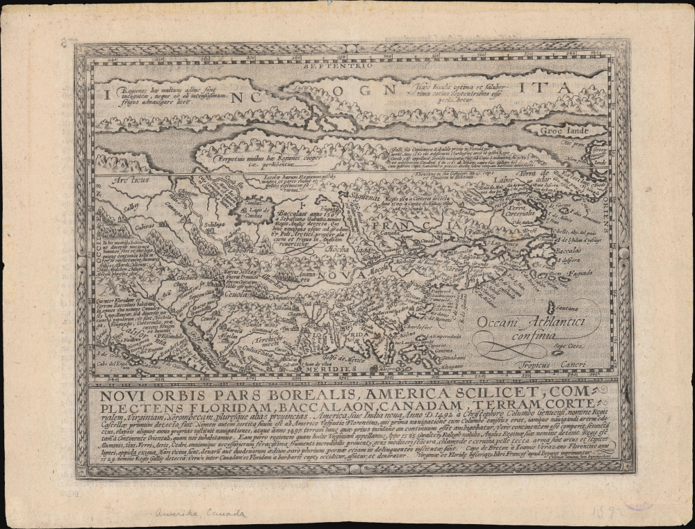
A beautifully engraved, rare, and important 1600 map of North America by Matthias Quad, in its first edition. This is one of the most significant obtainable maps to incorporate the cartography of Cornelis de Jode, John White, and Jacques Le Moyne. It is additionally significant for its postulation of an open Northwest Passage.
The map's most obviously arresting feature is Quad and De Jode's advance of a wide open Northwest Passage extending the entire width of North America. Despite the identification of these Arctic lands as 'incognita,' the cartographers' bold embrace of their geography speaks strongly of the hopes that North America may yet offer the coveted alternative passage to Asia. The large Arctic landmasses along the top of the map are derived from Mercator's legendary 1569 wall map - the first to utilize the Mercator Projection.
A Closer Look
Derived from Cornelis de Jode's 1593 Americae Pars Borealis, Quad's map covers North America from the unknown Arctic to the Gulf of Mexico and from the Pacific to the Atlantic. The map predates the significant inland exploration of Samuel de Champlain; it draws on some of the more important early explorations of North America, including those of Jacques Cartier, Sebastian Cabot, Giovanni Verrazano, Sir Walter Raleigh, John White, and Jacques Le Moyne.The map's most obviously arresting feature is Quad and De Jode's advance of a wide open Northwest Passage extending the entire width of North America. Despite the identification of these Arctic lands as 'incognita,' the cartographers' bold embrace of their geography speaks strongly of the hopes that North America may yet offer the coveted alternative passage to Asia. The large Arctic landmasses along the top of the map are derived from Mercator's legendary 1569 wall map - the first to utilize the Mercator Projection.
Sources: White and De Bry
This map is also significant for its incorporation, via De Jode, of the cartography of John White and Jacques Le Moyne, published 10 years earlier by Theodore De Bry. John White's mapping of Virginia and Carolina derived from Sir Walter Raleigh's 1584 attempt to colonize Roanoke Island and was the first cartographically advanced representation of the region. Similarly, Jacques le Moyne's map, focusing on Florida and (future) Georgia, reflects a French Huguenot attempt under Jean Ribaut and René de Laudonnière to establish a colony near modern-day St. Augustine. Both colonies were a disaster, with Roanoke mysteriously disappearing between Raleigh's resupply visits and the French attempt to colonize Florida wiped out by the Spanish. Nonetheless, although both colonies failed, they produced groundbreaking cartographic advances in terms of the general understanding of their respective regions. Both maps had a significant impact on subsequent cartography, particularly as seen here in Quad's map. Much of the toponymy attached to the eastern coast south of New England can be directly associated with these maps.Conibas
Also striking is the impressive inland sea, the Lago de Conibas, presented in the heart of the continent. Given the relatively unexplored nature of this region in the late 16th century, it is not certain from where the idea of Conibas was derived and what it is intended to represent. Nonetheless, there are some ideas. The first printed map of America to show a large inlet from the Arctic is Sebastian Munster's 1540 Novae Insulae XVII Nova Tabula. Munster is therein rendering Verazzano's Sea, a speculative inland sea opening to the Arctic or Pacific that Verrazano claimed to have discovered based upon misinterpretations of the Pamlico Sound and the Carolina Banks. Munster's inland sea was rather vague and formless, following the original speculative rendering laid down by Verrazano in his manuscript chart now stored at the Vatican. Most subsequent maps follow this convention, but Verazzano's Sea became smaller and smaller with each map. It was Giacomo Gastaldi (Shirley, 107), in his woodcut wall map of 1561, who finally gave Conibas the form we see here, i.e. extending inland via a narrowish channel and opening into a large inland lake. It was also Gastaldi who first used the term 'Conibaz' and established much of the toponomy of this region. In 1568, the idea was expounded upon by Andre Thevet, who credits Jacques Cartier's explorations (1535 - 1542) as its source. Thevet knew Cartier personally, and it is not unlikely that Gastaldi also met and spoke with the explorer. Cartier introduced the American Indian 'Cornibotz', or Wampum Shells. Cornibotz were supposedly obtained by cutting open the fleshy portions of a dead body and submerging it into a large lake. Shells would collect in the wounds, which could then be collected and converted into Wampum. From this, Gastaldi and Thevet, either in correspondence, independently, or directly from Cartier, developed the idea of Lake Conibas. Conibas subsequently appears in the 1593 map of America by Cornelius de Jode, the 1594 woodcut world map of Petrus Plancius, the 1595 atlas map of the northern Polar Regions by Gerard Mercator, the 1597 Cornelis van Wytfliet, and, as offered here, the 1600 Matthias Quad. Quad here actually uses both the term Conibas and Conibaz, further supporting Thevet's theory.Cities of Gold
In the southwest several of the supposed cities of gold are noted, among the Ciboa (Ciuola, really Zuni) and Azatlan (Ascatlan, legendary homeland of the Aztec peoples prior to their migration to the Valley of Mexico). Some believe that the second peninsula just to the west of Florida may represent an early attempt to map the protrusion of the Mississippi River Delta.Publication History and Census
This map was engraved by Johannes Bussemacher and originally published in Quad's 1600 Geographisch Handtbuch; the verso typography of the present example corresponds with this first, 1600 Bussemacher edition, with the verso page number 78. It appeared again in the 1608 Fasciculus Geographicus, verso page 82. It was published a third time in 1611 in the German (Munich) edition of Botero entitled Allgemeine Weltbeschreibung, lacking verso text.CartographerS
Matthias Quad (1557 - October 29, 1613) was Dutch engraver active in Cologne during the late 16th and early 17th centuries. Quad was born in the Netherlands and studied engraving under Johannes van Deutecum (fl. 1552 - 1606) of Deventer and Hendrick Goltzius (1558-1616) of Haarlem. Around 1580 he relocated to Heidelberg or Cologne where he primarily engraved geographical texts in conjunction with fellow publisher Johann Bussemacher. In 1608 he published an atlas, Fasciculus Geographicus, with Bussemacher in Cologne. In 1609, another major work, his Teutscher Nation Herligkeit, a historico-cultural regional study of Germany, was published by Wilhelm Lutzenkirchen . More by this mapmaker...
Johann Bussemacher (fl. c. 1580 - 1613) was a German publisher, engraver, art dealer, and bookseller active in Cologne in the late 16th and early 17th centuries. He was trained as a copper engraver in Dusseldorf, where he was born. Around in 1583 he established his own imprint and a publishing concern in Cologne. Bussemacher was for a time the largest and most successful publisher in Cologne. He is commonly associated with producing engraved images of saints and noble personages, but he also issued several maps in conjunction with Matthias Quad. Learn More...
Source
Quad, M., Geographisch Handtbuch, (Cologne: Bussemacher) 1600.
Condition
Very good. Wide margins. German text on verso. Few tiny, unobtrusive wormholes, else excellent.
References
Burden, P., The Mapping of North America, #133. Cumming, W., The Southeast in Early Maps, #24. OCLC 635114770, 54642411, 937705536.