Digital Image: 1795 Branciforte Map of Oaxaca de Juarez, Mexico
Oaxaca-branciforte-1795_d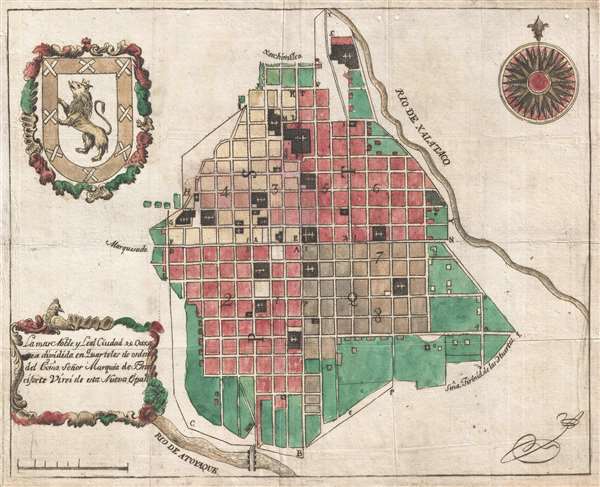

Title
La mas Noble y Leal Ciudad de Oaxaca dividida en Quarteles de orden del exmo. Señor Marques de Branciforte Virei de esta Nueva España.
1795 (undated) 11 x 14 in (27.94 x 35.56 cm) 1 : 10000
1795 (undated) 11 x 14 in (27.94 x 35.56 cm) 1 : 10000
Description
FOR THE ORIGINAL ANTIQUE MAP, WITH HISTORICAL ANALYSIS, CLICK HERE.
Digital Map Information
Geographicus maintains an archive of high-resolution rare map scans. We scan our maps at 300 DPI or higher, with newer images being 600 DPI, (either TIFF or JPEG, depending on when the scan was done) which is most cases in suitable for enlargement and printing.
Delivery
Once you purchase our digital scan service, you will receive a download link via email - usually within seconds. Digital orders are delivered as ZIP files, an industry standard file compression protocol that any computer should be able to unpack. Some of our files are very large, and can take some time to download. Most files are saved into your computer's 'Downloads' folder. All delivery is electronic. No physical product is shipped.
Credit and Scope of Use
You can use your digial image any way you want! Our digital images are unrestricted by copyright and can be used, modified, and published freely. The textual description that accompanies the original antique map is not included in the sale of digital images and remains protected by copyright. That said, we put significant care and effort into scanning and editing these maps, and we’d appreciate a credit when possible. Should you wish to credit us, please use the following credit line:
Courtesy of Geographicus Rare Antique Maps (https://www.geographicus.com).
How Large Can I Print?
In general, at 300 DPI, you should at least be able to double the size of the actual image, more so with our 600 DPI images. So, if the original was 10 x 12 inches, you can print at 20 x 24 inches, without quality loss. If your display requirements can accommodate some loss in image quality, you can make it even larger. That being said, no quality of scan will allow you to blow up at 10 x 12 inch map to wall size without significant quality loss. For more information, it is best consult a printer or reprographics specialist.
Refunds
If the high resolution image you ordered is unavailable, we will fully refund your purchase. Otherwise, digital images scans are a service, not a tangible product, and cannot be returned or refunded once the download link is used.
Cartographer
Manuel Galicia de Villavicencio (1730 - c. 1788) was a line and map engraver active in Mexico City during the late 18th century (fl. c. 1753 - 1795). Most of what we know of him comes from Inquisition Archives. Villavicencio ran afoul of the Inquisition in 1768 over an engraving of Sant Josaphat that ran contrary to church doctrine. According to Inquisition records, Villavicencio owned an engraving and print shop at Calle de la Polilla, Mexico City, which he operated with his wife, Petra de Monterrey. The shop did a robust business with more than 100 engraving attributed to him. He died around 1788. At this point, according to an advertisement in the Gazeta de México the shop relocated to Calle de la Canoa, 12. Most likely it came under management of his wife, Petra, who presumably learnt engraving from her husband. Villavicencio produced few maps, but his work is distinctive for his idiosyncratic engraving style. Of the three, two were issued posthumously, probably from old plates partially finished. Known maps include a map of Mexico City (December 12, 1782), an unsigned map of Oaxaca City (1795), and an unsigned map of San Luis Potosi (1794). The first map, Mexico City, dedicated to Martín de Mayorga Ferrer, viceroy of New Spain from 1779 to 1783, appears to have been engraved by two separate engravers, operating in a similar style, but with varying degrees of competency - likely Villavicencio shared the work with his wife. The later maps are dedicated to the Miguel de la Grúa Talamanca de Carini and Branciforte, Viceroy of New Spain from 1794 -1798, and were probably engraved by Villavicencio's widow, Petra, as they were issued after his death and exhibit similar but less sophisticated work. All three maps relate to urban redistricting that occurred in Mexican colonial cities in the second half of the 18th century. More by this mapmaker...
References
Archivo General de la Nación. México, D.F.