1945 Je Cherche and Mercier Map of Occupied Germany (World War II)
OccupationAllemagne-jecherche-1945$950.00

Title
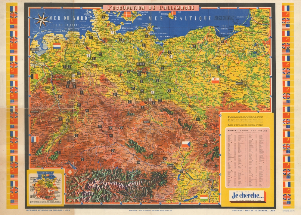
L'Occupation de l'Allemagne.
1945 (dated) 25.25 x 34.5 in (64.135 x 87.63 cm) 1 : 1724000
1945 (dated) 25.25 x 34.5 in (64.135 x 87.63 cm) 1 : 1724000
Description
This is a 1945 'Je Cherche' and Jacques Mercier map of Germany just after the end of World War II in Europe. It is made in a dynamic cartographic style that allows users to change and interact with the map as real-time events unfold.
A Closer Look
Coverage embraces from Belgium, Luxembourg, and France, to Poland and from Denmark to Austria and Hungary. Cities, towns, and villages are labeled, including Berlin, Vienna, Prague, Bratislava, Budapest, Warsaw, and Amsterdam. Flags mark Nazi prisoner-of-war camps. Nearly 100 camps were established by the Nazis during to house hundreds of thousands of captured Allied soldiers. An inset map in the lower-left explains the map notations, and compliments a city index at right.The Occupation of Germany and the Flags
A short text just above the city index and readsThe flags along the sides can be cut apart and used to mark occupation zones. (Cut out each flag with the yellow part, fold it, wrap it around a pin on the back of the flag.)The original French reads:
Les drapeaux figurant latéralement peuvent être découpés pour server à delimiter les zones d'occupation (Découper chaque Drapeau avec sa partie jaune, coller cette dernière, entourant une épingle, au verso du drapeau.)The fact that the Allied Occupation Zones are indented to be identified dynamically, and not printed directly on the map, implies that this map was published before the zones had been formally established. Mercier and 'Je cherche' must have felt that there would be some arguments and conflicts over the exact configuration. The practice of making interactive maps was not uncommon during the war. Paris-soir, a newspaper in Paris, published a map of Europe at the beginning of the war the employed the same concept, allowing readers to follow the ever-changing war fronts without depending on acquiring a new map.
Publication History and Census
This map was created by Jacques Mercier and published by 'Je cherche' in 1945. We are aware of only one other known example, which is cataloged in OCLC as being part of the collection at the Université Bordeaux Montaigne.Condition
Very good. Exhibits wear and toning along original fold lines. Verso repairs to fold separations. Closed margin tears professionally repaired on verso.
References
OCLC 932062494.