An appealing example of Jeremiah Greenleaf's scarce 1840 map of Ohio that appeared in the first edition of his Universal Atlas. It displays the state in a period of rapid development, driven by new settlers and a growing canal and road network.
A Closer Look
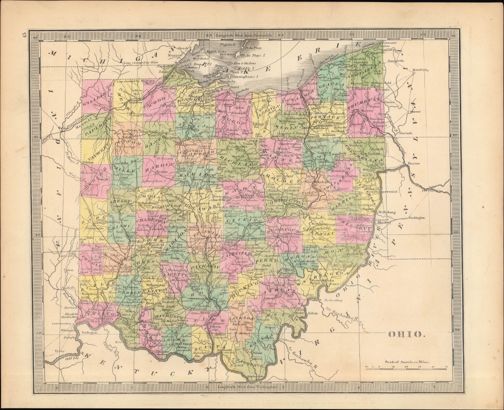
Ohio is depicted with counties clearly marked and color-shaded for easy distinction. Portions of neighboring states also appear with cities and other features noted. Major roads, including the 'National Road' cutting east-west across the middle of the state, are indicated by dashed double lines, while minor roads are marked with undashed double lines. Towns and cities, forts, and waterways are also displayed. Many of the town and county names here would later be changed slightly, such that Cleavland became Cleveland, Strongville became Strongsville, Dark County became Darke, and so on.
The Indian Reservations in the northwestern part of the state were designated according to the 1817 Treaty of Fort Meigs (the fort itself is labeled just outside Perrysburg near Toledo). However, by the time of publication, most Native Americans had been forcefully removed from the area and the reservations dismantled.Canals
The dashed line in the state's west is not an early railroad but the partially completed Miami and Erie Canal; it was later expanded along the lines shown as proposed here. The Ohio and Erie Canal is also displayed, linking Cleveland with the Columbus area and eventually to the Ohio River at Portsmouth. These highways of the early republic were important for the development of Ohio and its economic ties with eastern states.The 'Toledo War'
In the upper left quadrant, there is a disputed boundary with Michigan associated with the bloodless Toledo War of 1835 and 1836. Both states laid claim to a sliver of land known as the Toledo Strip, valuable for its access to the port of Toledo on Lake Erie. Both states raised militias and threatened military action from across the Maumee River, but nothing more severe than taunting ensued. Michigan acquiesced to Ohio's border demands in order to be admitted to the Union in 1837, gaining in consolation the mineral-rich Upper Peninsula. Here, Greenleaf follows Burr (see 'Publication History and Census' below) in deciding in favor of Michigan (see Rumsey 4850.044), though by the last edition of his atlas had changed the Michigan and Ohio maps to reflect the negotiated settlement.The National Road
The National Road, begun in 1811 and completed in 1837, was the first major improved highway in the United States. The road connected the Ohio and Potomac Rivers, and stretched from Cumberland, Maryland to Vandalia, Illinois, the Illinois state capital at the time. Construction of the road came to an end when federal funding dried up in the Panic of 1837.Publication History and Census
This map was published by Jeremiah Greenleaf for the first edition of his Universal Atlas, published in 1840. Like the other maps in Greenleaf's atlas, it was based on the 1836 edition of A New Universal Atlas by David Burr, from whom he acquired the map plates, with updates added. The remnants of Burr's copyright can even be faintly seen in the bottom margin. But Greenleaf has added some updates, for instance including Lucas County (established 1836), though not Erie (1838), suggesting that his information was slightly out of date by the time of publication, understandable given the rapid pace of change in what were then the 'western' states and territories.
CartographerS
Jeremiah Greenleaf (1791 - 1864) is a little known but highly admired American cartographer of the early 19th century. He published from roughly 1830 to 1850. His most important work is A New Universal Atlas; Comprising of all the Principal Empires, Kingdoms, and States Throughout the World and Forming a distinct Atlas of the United States, published in several editions in the 1840s. Many of his maps are reformatted versions of his contemporary David Burr's much admired cartographic works. Greenleaf's maps are extremely rare and admired for their stunningly vivid pastel color washes. More by this mapmaker...
David Hugh Burr (August 18, 1803 - December 25, 1875) of one of the first and most important truly American cartographers and map publishers. Burr was born in Bridgeport Connecticut in August of 1803. In 1822 Burr moved to Kingsboro, New York to study law. A year and a half later he was admitted to the New York Bar association. Burr must have questioned his choice of careers because shortly after being admitted to the Bar, he joined the New York State Militia. Though largely untrained in the art of surveying, Burr was assigned to work under Surveyor General of New York, Simeon De Witt, to survey several New York Roadways. Seeing a window of opportunity, Burr was able to negotiate with the governor of New York at the time, De Witt Clinton, to obtain copies of other New York survey work in order to compile a map and Atlas of the state of New York. Recognizing the need for quality survey work of its territory, the government of New York heartily endorsed and financed Burr's efforts. The resulting 1829 Atlas of the State of New York was the second atlas of an individual U.S. state and one of the most important state atlases ever produced. Burr went on to issue other maps both of New York and of the United States in general. In cooperation with publishing firm of Illman & Pillbrow, he produced an important New Universal Atlas and, with J.H. Colton, several very important maps of New York City. In recognition of this work, Burr was appointed both "Topographer to the Post office" and "Geographer to the House of Representatives of the United States". Later, in 1855, Burr was assigned to the newly created position of Surveyor General to the State of Utah. Burr retired from the position and from cartographic work in general in 1857 when light of some of his financial misdeeds and frauds came to light. He was accused of submitting false expense reports and underpaying employees, among other indiscretions. Learn More...
Source
Greenleaf, J., New Universal Atlas, (Brattleboro, Vermont: Greenleaf) 1849.
Very good. Slight toning and foxing in margins.
Rumsey 4850.043.