This item has been sold, but you can get on the Waitlist to be notified if another example becomes available, or purchase a digital scan.
1909 Rand McNally Railroad Map of Oklahoma
Oklahoma-randmcnally-1909$75.00

Title
Map of Oklahoma.
1909 (dated) 20 x 27 in (50.8 x 68.58 cm) 1 : 823680
1909 (dated) 20 x 27 in (50.8 x 68.58 cm) 1 : 823680
Description
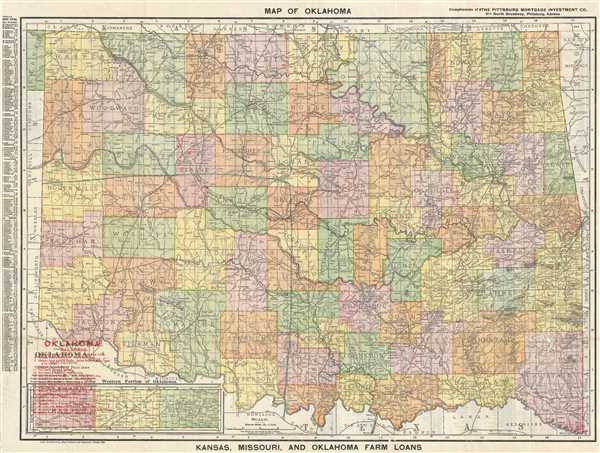
This is a 1909 Rand McNally railroad map of Oklahoma. The map depicts the state of Oklahoma from New Mexico and Texas to Arkansas and Missouri and from Kansas to Texas with the majority of the panhandle depicted in an inset map at the lower left. Counties are labeled and differentiated by different colors. An index of chief cities in Oklahoma, organized by population, is located along the left margin.
Curiously, an index of Oklahoma railroads appears to have been overprinted on this example. 19 different railroads are numerically identified throughout the state, with numbers overprinted throughout the state marking the routes of the different railroads. The index is located in the lower left corner, although its use is limited because the printing is not easily legible. Also, a large portion of southwestern Oklahoma is blocked off in what appears to be colored pencil. We have no idea what to make of this notation. Thus, while the Rand McNally plates were used for the general map, there is much more information here than is present on a standard Rand McNally.
This map was created By Rand, McNally and Company of Chicago in 1908 and updated in 1909. This example was distributed by The Pittsburg Mortgage Investment Company of Pittsburg, Kansas.
Cartographer
Rand, McNally and Co. (fl. 1856 - present) is an American publisher of maps, atlases and globes. The company was founded in 1856 when William H. Rand, a native of Quincy, Massachusetts, opened a print shop in Chicago. Rand hired the recent Irish immigrant Andrew McNally to assist in the shop giving him a wage of 9 USD per week. The duo landed several important contracts, including the Tribune's (later renamed the Chicago Tribune) printing operation. In 1872, Rand McNally produced its first map, a railroad guide, using a new cost effective printing technique known as wax process engraving. As Chicago developed as a railway hub, the Rand firm, now incorporated as Rand McNally, began producing a wide array of railroad maps and guides. Over time, the firm expanded into atlases, globes, educational material, and general literature. By embracing the wax engraving process, Rand McNally was able to dominate the map and atlas market, pushing more traditional American lithographic publishers like Colton, Johnson, and Mitchell out of business. Eventually Rand McNally opened an annex office in New York City headed by Caleb S. Hammond, whose name is today synonymous with maps and atlases, and who later started his own map company, C. S. Hammond & Co. Both firms remain in business. More by this mapmaker...
Condition
Very good. Backed on archival tissue for stability. Text on verso.