This item has been sold, but you can get on the Waitlist to be notified if another example becomes available, or purchase a digital scan.
1940s Pictorial Map of Historic Deerfield, Massachusetts
OldDeerfield-anon-1940$87.50

Title
Old Deerfield.
1940s (undated) 20.5 x 13.25 in (52.07 x 33.655 cm) 1 : 5760
1940s (undated) 20.5 x 13.25 in (52.07 x 33.655 cm) 1 : 5760
Description
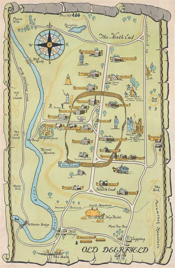
This is a c. 1940s pictorial map of Historic Deerfield (Old Deerfield), Massachusetts. The map depicts the town from The North End to The Bars and from the Deerfield River to Pocumtuck Mountain. Beautifully illustrated, each historic home is labeled with its original owner's name on a yellow banner. Some of the houses depicted include the Ashley House, the Stebbins House, and the Frary House. The Town Hall, Memorial Hall, the Deerfield Academy, the Manse, and the Brick Church are also labeled. Several townspeople, including Hannah Beaman and some school children, are illustrated, as is the purchase of Deerfield from the Pocumtucks in 1666.
This map, though unsigned and undated, most likely dates from the 1940s. It is incredibly scarce as we have been unable to locate any other examples.
This map, though unsigned and undated, most likely dates from the 1940s. It is incredibly scarce as we have been unable to locate any other examples.
Condition
Very good. Even overall toning. Blank on verso.