This is an 1898 Poole Brothers map of Washington and Oregon issued to promote Oregon emigration, land sales, and railroad travel. The map was published on behalf of the Oregon Railroad and Navigation Company and the Southern Pacific Railroad.
Encouraging Emigration
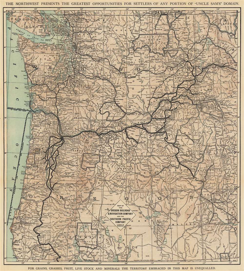
Black lines trace the rail networks with white dots marking stops. Thinner lines illustrate the routes of the Great Northern Railway and the Northern Pacific Railroad in Washington. Perhaps to entice visitors (and more likely hopeful settlers) from San Francisco, a thick dashed line highlights the Oregon Railroad and Navigation Company's steamship route from Portland to San Francisco. The Portland and Asiatic Steamship Company's route to China and Japan is noted as well, underscoring Portland as a city with connections, another attractive point for possible newcomers. Slogans along the top and bottom promote the region's natural wealth and the opportunities it presents.The Oregon Railroad and Navigation Company
The Oregon Railroad and Navigation Company operated from 1896 until 1910, when control was fully transferred to Union Pacific. The Oregon Railroad and Navigation Company's direct predecessor, the Oregon Railway and Navigation Company (ORN) was incorporated on June 13, 1879, by Henry Villard and could trace its lineage to 1860. It operated steamboats on the Columbia, Willamette, and Snake Rivers as well. Villard, who also owned the Oregon and California Railroad, jealously guarded the ORN's operating monopoly in Oregon and worked hard to keep both the Northern Pacific and Union Pacific out of Oregon. He even managed to gain a controlling stake in Northern Pacific in 1881. The ORN operated the only transcontinental route to Portland and concluded a deal with Union Pacific to operate as their connection in Oregon in 1884. Villard was ousted as president of the ORN in late 1883, which soon led to Northern Pacific and Union Pacific 'encroaching' on the ORN's territory in Oregon. This led to ORN leasing its operation to Union Pacific in 1887. Union Pacific went bankrupt in 1893, as did the ORN and Union Pacific's subsidiary in Oregon the Oregon Short Line. This ended Union Pacific's lease of the ORN and also forced the ORN to reorganize as the Oregon Railroad and Navigation Company in 1896.Publication History and Census
This map was created by the Poole Brothers and issued by the passenger departments of the Oregon Railroad and Navigation Company and the Southern Pacific Company in 1898. We note two cataloged examples of the 1898 edition, one at the New York Public Library and another with Washington State University. It is scarce on the private market. The presently offered 1898 edition is not cataloged in OCLC, but a single example of the 1904 example does appear in that database.
Cartographer
Poole Brothers (fl. c. 1880 - 1968) were a Chicago based firm active in the late 19th and early 20th century with an initial focus on promotional railroad maps. Poole Brothers was founded by George Amos Poole, one of the original four partners in the firm that would become Rand McNally, and his brother William H. Poole. Poole started his own firm, Poole Brothers, as a direct competitor to Rand McNally for the lucrative railroad business. Like many of its competitors, Poole Brothers maintained an office on Chicago's Printer's Row (downtown Loop district). Nevertheless, the two firms, along with Cram and Company, seem to have come to an accord, at least with regard to price-fixing, for which they were cited by the Federal Trade Commission in 1948. Their earliest known work is an 1880 map of Yellowstone National Park. Afterward they went on to produce a vast range of maps and other print products including tickets, cards, coupons, and restaurant menus. In time Poole Brothers merged with Newman-Randolph, which was then acquired by the American Can Company in the early 1960s. The American Can Company liquidated its printing concerns later in the same decade. More by this mapmaker...
Very good. Light wear along original fold lines. Verso repairs at fold intersections.
New York Public Library Map Div. 17-5113. Washington State University sc001 2.1 1906.