This item has been sold, but you can get on the Waitlist to be notified if another example becomes available, or purchase a digital scan.
1934 Japanese Propaganda Map of Pacific World War II Theater (WWII)
PacificWarDefense-taisho13-1934$625.00

Title
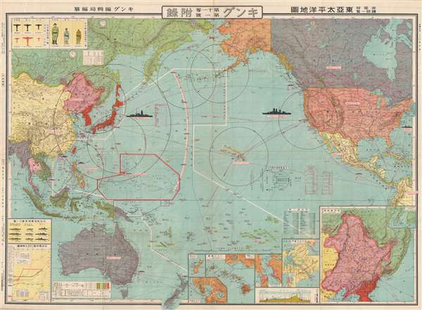
東亞太平洋地圖 / 非常時國防一覽 / East Asia Pacific Map / A National Defense View at a Special Time. / Hijōji kokubō ichiran tōa-taiheiyō-zu.
1934 (dated) 30 x 42 in (76.2 x 106.68 cm) 1 : 22000000
1934 (dated) 30 x 42 in (76.2 x 106.68 cm) 1 : 22000000
Description
This is a fascinating and important 1934, Taisho 13, World War II Japanese propaganda map of the Pacific foreshadowing the Pearl Harbor Attack, the Aleutian Campaign, and the Philippine Campaign. Covering the entire Pacific, from the Bay of Bengal to New York and From the Behring Strait to New Zealand, this map outlines the overarching Japanese strategy for World War II in surprising detail. The map juxtaposes Japanese forces and territory with Russian and American Forces. The Japanese Empire, including Japan, Hokkaido, Korea, Taiwan, and southern Sakhalin, and Micronesia, is outlined in red, while areas of Japanese influence, including Korea and Thailand, are in lighter red. Important flight and shipping routes across the Pacific are noted, as are military bases.
When this map was issued, in in 1934, World War II (1939 – 1945) had not yet officially broken out, but in the Pacific, preliminary conflicts between Japan and its neighbors had been underway since the 1920s. The Japanese strategy for dominating the Pacific is here clearly illustrated. The map identifies 8 spheres of influence, which, if their center was controlled, control of the entire region would follow. These included
It is of note that his map was issued well before the full outbreak of the Pacific War. The map foreshadows the Pearl Harbor Attack, the Aleutian Campaign, and the Philippine Campaign, as well as intended targets that the Japanese never managed to attack, such as San Francisco. It was prepared by Kingu Henshūkyoku and published in Tokyo by, Dai Nihon Yūbenkai Kōdansh. This map is uncommon, with the OCLC citing only 3 examples, most from a 1935 edition. A truly remarkable document.
When this map was issued, in in 1934, World War II (1939 – 1945) had not yet officially broken out, but in the Pacific, preliminary conflicts between Japan and its neighbors had been underway since the 1920s. The Japanese strategy for dominating the Pacific is here clearly illustrated. The map identifies 8 spheres of influence, which, if their center was controlled, control of the entire region would follow. These included
- Japan - with a radius that includes Taiwan, Korea, Manchuria, parts of China, and the northern Luzon.
- The Bonin Islands – where there was an important Japanese Base that allowed dominance of Micronesia.
- Manila – allowing domination of the resource rich Philippines and parts of Indonesia. (invaded December, 1941)
- Vladivostok – control over which would keep Soviet forces out of the Pacific.
- Kiska, Aleutian Islands – from which Pacific shipping routes could be controlled. (invaded June 3, 1942)
- Dutch Harbor, Aleutian Islands – from which Pacific shipping routes could be controlled. (bombed June 3, 1942)
- Hawaii – a vital stepping stone to the United States mainland and essential for control of the Pacific. (bombed December 7, 1941)
- San Francisco - essential to breaking American influence in the Pacific.
It is of note that his map was issued well before the full outbreak of the Pacific War. The map foreshadows the Pearl Harbor Attack, the Aleutian Campaign, and the Philippine Campaign, as well as intended targets that the Japanese never managed to attack, such as San Francisco. It was prepared by Kingu Henshūkyoku and published in Tokyo by, Dai Nihon Yūbenkai Kōdansh. This map is uncommon, with the OCLC citing only 3 examples, most from a 1935 edition. A truly remarkable document.
Condition
Very good. Wear on original fold lines. Some minor verso reinforcements at fold intersections. Minor hole in Canada above Great Lakes.
References
OCLC 271748299.