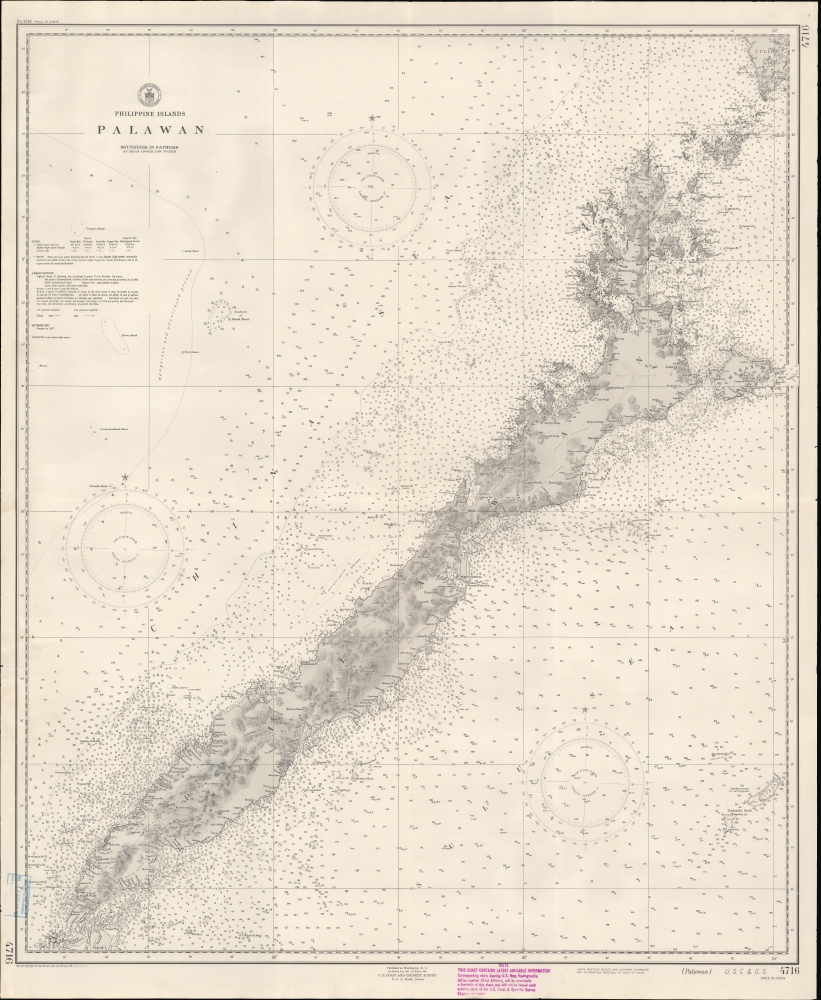
This is a 1938 U.S. Coast and Geodetic Survey (USCGS) nautical chart or maritime map of the island of Palawan in the Philippines, published just before World War II (1939 - 1945). While not made during WWII, with tensions rising in the Asia-Pacific sphere, the U.S. Government likely recognized that updating their charts was increasingly critical.
A Closer Look at the Map
Coverage extends from Culion Island in the northeast to the islands that today constitute the Municipality of Balabac in the southwest (here as Pandanan I, Bugsuk I, etc.), with the Sulu Sea to the east and the South China Sea to the west. Inland topography is defined by contouring with elevations in feet. Depth soundings appear along the coast, providing essential maritime data. Information concerning tides, abbreviations, and other important data is included below the title at center-left.Palawan and the Second World War
Although not necessarily intended for military use, this map would have proved valuable in military operations as World War II broke out in the Pacific soon after it was issued. After the Japanese Invasion of the Philippines (1941 - 1942), Filipino resistance fighters operated out of the jungles of Palawan, feeding intelligence to the Americans and helping escapees from the many Japanese prisoner of war camps established there. Palawan was liberated in the spring of 1945 with minimal U.S. casualties; in fact, far more Americans died in a massacre of POWs by retreating Japanese troops than died in combat.Palawan - Ecotourist Paradise
Though not the largest island in the Philippines archipelago, Palawan is the largest province in the Republic of the Philippines, as larger islands like Mindanao and Luzon are subdivided into multiple provinces. In recent years, Palawan has become a popular tourist destination as the historical underdevelopment of the island has been turned to an advantage. It is now world-renowned for its clean air, clear water, pristine beaches, vast old-growth forests. The island hosts two UNESCO World Heritage sites there are efforts to add more.Publication History and Census
This map was published by the U.S. Coast and Geodetic Survey in Washington, D.C. in January 1938. This is the 9th edition of this map, the first dating to 1903. The only known institutional holding of this edition is at Stanford University. Scarce to the market.
Cartographer
The Office of the Coast Survey (later the U.S. Geodetic Survey) (1807 - present), founded in 1807 by President Thomas Jefferson and Secretary of Commerce Albert Gallatin, is the oldest scientific organization in the U.S. Federal Government. Jefferson created the "Survey of the Coast," as it was then called, in response to a need for accurate navigational charts of the new nation's coasts and harbors. The first superintendent of the Coast Survey was Swiss immigrant and West Point mathematics professor Ferdinand Hassler. Under the direction of Hassler, from 1816 to 1843, the ideological and scientific foundations for the Coast Survey were established. Hassler, and the Coast Survey under him developed a reputation for uncompromising dedication to the principles of accuracy and excellence. Hassler lead the Coast Survey until his death in 1843, at which time Alexander Dallas Bache, a great-grandson of Benjamin Franklin, took the helm. Under the leadership A. D. Bache, the Coast Survey did most of its most important work. During his Superintendence, from 1843 to 1865, Bache was steadfast advocate of American science and navigation and in fact founded the American Academy of Sciences. Bache was succeeded by Benjamin Pierce who ran the Survey from 1867 to 1874. Pierce was in turn succeeded by Carlile Pollock Patterson who was Superintendent from 1874 to 1881. In 1878, under Patterson's superintendence, the U.S. Coast Survey was reorganized as the U.S. Coast and Geodetic Survey (C & GS or USGS) to accommodate topographic as well as nautical surveys. Today the Coast Survey is part of the National Oceanic and Atmospheric Administration or NOAA. More by this mapmaker...
Very good. Some wear and dampstaining along edges, small rip in left margin near center.
OCLC 921298545.