1764 Bellin City Plan or Map of Palermo, Italy
Palerme-bellin-1764$250.00

Title
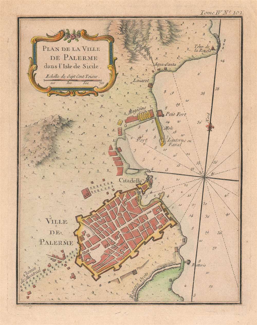
Plan de la Ville de Palerme dans l'isle de Sicile.
1764 (undated) 9.75 x 7.75 in (24.765 x 19.685 cm) 1 : 31000
1764 (undated) 9.75 x 7.75 in (24.765 x 19.685 cm) 1 : 31000
Description
This is a beautiful 1764 Jacques-Nicolas Bellin city plan or map of Palermo, Italy. The city occupies the bottom portion of the map, with its citadel and shore battery both labeled. its city walls are clearly illustrated. The Chemin de Montreal (the road to Monreale) is labeled to the left of the city and heads west.The Oreto River appears south of Palermo, while the city's port is to its north. A small fort and storage facilities near the port are both illustrated and labeled, along with a signal lantern. An aqueduct brings water from the nearby mountains to a site labeled 'Aqua Santa', which would translate to 'Holy Water'. Today, Palermo is the economic and tourist capital of Sicily and draws people because of its history, art, culture, music, and food. Its Mediterranean climate, incredible architecture, and nightlife all appeal to tourists. The city is also home to eight UNESCO World Heritage sites dating from the era of the Norman Kingdom of Sicily (1130 - 1194): three cathedrals, two palaces, and a bridge. Two other cathedrals, in Cefalù and Monreale, are also part of the UNESCO World Heritage Site designation.
Publication History and Census
This map was drawn by Jaques-Nicolas Bellin, engraved by P. Croisey, and published by Bellin in his Le petit atlas maritime in 1764. Three examples are cataloged in OCLC and are part of the institutional collections at the Bibliothèque national de France in Paris, the Bayerische Staatsbibliothek in Munich, and the Biblioteca Nacional de España in Madrid.CartographerS
Jacques-Nicolas Bellin (1703 - March 21, 1772) was one of the most important cartographers of the 18th century. With a career spanning some 50 years, Bellin is best understood as geographe de cabinet and transitional mapmaker spanning the gap between 18th and early-19th century cartographic styles. His long career as Hydrographer and Ingénieur Hydrographe at the French Dépôt des cartes et plans de la Marine resulted in hundreds of high quality nautical charts of practically everywhere in the world. A true child of the Enlightenment Era, Bellin's work focuses on function and accuracy tending in the process to be less decorative than the earlier 17th and 18th century cartographic work. Unlike many of his contemporaries, Bellin was always careful to cite his references and his scholarly corpus consists of over 1400 articles on geography prepared for Diderot's Encyclopedie. Bellin, despite his extraordinary success, may not have enjoyed his work, which is described as "long, unpleasant, and hard." In addition to numerous maps and charts published during his lifetime, many of Bellin's maps were updated (or not) and published posthumously. He was succeeded as Ingénieur Hydrographe by his student, also a prolific and influential cartographer, Rigobert Bonne. More by this mapmaker...
P. Croisey (fl. c. 1765 – c. 1800) was a French line-engraver active in the 18th century. Croisey was based in Versailles, France and is best known for his fine portrait of Marie Antoinette, when Dauphiness. He also maintained a location on Rue Haute-Feuille, Pairs. One of his early trade cards survives in which he describes himself as a geographical engineer and engraver of civil and military architecture, topography, and geography. His wife, Madame Croisey was also an engraver, specializing in music and text. He died around 1800. Learn More...
Source
Bellin, J. N., Le petit atlas maritime (Paris: Bellin) 1764.
Condition
Very good. Even overall toning. Blank on verso.
References
OCLC 494596220, 733631756.