This item has been sold, but you can get on the Waitlist to be notified if another example becomes available, or purchase a digital scan.
1924 Hachette Pictorial City Plan or Pocket Map of Paris, France
Paris-hachette-1924$125.00

Title
Plan de Paris.
1924 (undated) 27 x 32 in (68.58 x 81.28 cm) 1 : 16000
1924 (undated) 27 x 32 in (68.58 x 81.28 cm) 1 : 16000
Description
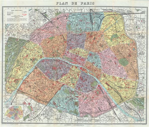
This is an extremely appealing c.1924 tourist pocket map or plan of Paris, France, by the Librarie Hachette. Centered on the Seine River, it covers embastilled Paris as contained in the Thiers Wall, and its immediate vicinity, including the Bois de Boulogne and part of the Bois de Vincennes. It reflects the transformation and modernization of Paris under Napoleon III and Georges-Eugene Haussmann.
Known in French as the 'Grands Travaux,' Haussmann's redesign of Paris defined it as a modern city, with narrow alleyways and confusing streets replaced by a broad network of grand boulevards, imposing facades, parks, and monuments.
Paris proper is colored in appealing pastels and is divided according to 20 Arrondisments. Shows exceptionally remarkable attention to detail in the public gardens where subtle expressions of landscape design are apparent. The map also notes individual streets, monuments, churches, town halls, railways, gardens, bridges and palaces. Identifies countless important buildings and monuments, including the Eiffel Tower, the Louvre, the Hotel des Invalides, the Jardin des Tuileries and many other Parisian landmarks.
Although undated, the state of development of the Paris Metro, particularly the extension of the Metro Line 7, suggests that this map must have been printed around 1924 – 1925, before the extension of the 7 from  Palais Royal to Pont Marie. The map is accompanied by a 45 page booklet which includes a street index and a visitor's guide to the public buildings, theaters, museums and places of amusements, as well as a complete street index.
An altogether marvelous decorative map. Published by the Librarie Hachette, 79, Boulevard Saint-Germain, Paris.
Cartographer
Hachette and Company (fl. 1826 – present) was founded by Louis Hachette (1801 - 1864) in 1826 with the purchase of the Paris Bookshop Brédif. Shortly after acquiring the bookshop Louis Hachette began publishing Le Journal pour Tous, a successful general interest magazine. He also published a series of useful reference works which were sold through Paris in bookshops, train stations, and public offices. These included multiple maps and atlases geared toward the tourist visiting Paris for the first time. Louis Hachette himself died in 1864, but his empire continued to grow under the governance of his sons. Eventually the Hachette publishing firm came to dominate French publishing and attracted international interest. Via a series of mergers and acquisitions the firm eventually came under the control of Filipacchi Media and was rename Hachette-Filipacchi. Today the firm publishes books and magazines internationally. More by this mapmaker...
Condition
Very good. Minor wear and verso repair along original fold lines. Accompanied by original cardboard binder (back cover missing) and a 45 page booklet.