This item has been sold, but you can get on the Waitlist to be notified if another example becomes available, or purchase a digital scan.
1770 Philippe de Pretot Map of Paris and its Environs, France
Paris-pretot-1770$150.00

Title
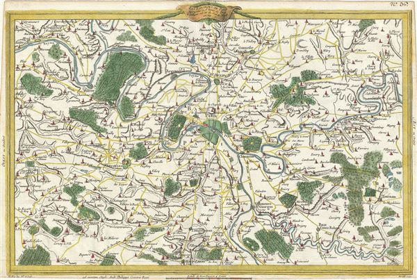
Les Environs De Paris assujettis a 18 lieues de l'Est a l'Ouest sur 12 du Sud au Nord.
1770 (dated) 11.5 x 17.5 in (29.21 x 44.45 cm) 1 : 250000
1770 (dated) 11.5 x 17.5 in (29.21 x 44.45 cm) 1 : 250000
Description
A beautiful hand colored 1770 map of Paris and its environs by Etienne Andre Philippe de Pretot. Centered over the city of Paris, it covers the Seine valley from Juziers to Guignes. The map offers extraordinary detail throughout showing gardens, forests, churches, roads, rivers, estates surrounding the city proper and other topographical details. This map was issued as plate no. 36 in Etienne Andre Philippe de Pretot's Recueil De Cartes Pour L'Etude De L'Histoire De France.
Cartographer
Etienne Andre Philippe de Pretot (1710 - March 6, 1787) was a French schoolmaster and geographer active in the middle part of the 18th century. Pretot was a member of the Academies de Rouen and d'Angers. This corpus includes various publications on history, cosmography, and geography. Little else, unfortunately, is known of his life. More by this mapmaker...
Source
Philippe de Pretot, E. A., Recueil De Cartes Pour L'Etude De L'Histoire De France, (Paris) 1787.
Condition
Very good. Original centerfold. Blank on verso.
References
Vallee, Leon, Catalogue des plans de Paris et des cartes de l'ile de France, (Bibliotheque Nacionale) 2152.