1839 Lithograph Reduction of the Only Surviving Map of the Roman Roads
PeutingerTable-maltebrun-1839$200.00

Title
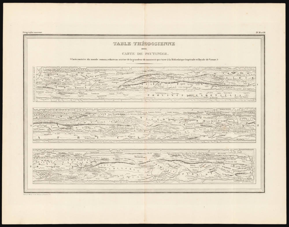
Table Théodosienne dite Carte de Peutinger.
1839 (undated) 10.75 x 16.25 in (27.305 x 41.275 cm)
1839 (undated) 10.75 x 16.25 in (27.305 x 41.275 cm)
Description
This is a 19th century printing of the Peutinger Table, one of the only and most important survivals of ancient Roman geography. It is a reduction of the only surviving example of an itinerarium pictum, a visual guide to the Roman road system. Its title here, Table Théodosienne, refers to the assumption that the map was drawn during the reign of Emperor Theodosius.
The unusual distortions would have been dictated by its original medium: it is likely to have been drawn on papyrus, placing no limit on length of the document but severely curtailing its width. Thus, distances from east to west are shown at larger scale than those from north to south, and the actual direction of roads running north to south is often ignored entirely. The usefulness of the map depended on the existence of the Roman roads themselves: a traveler, wisely keeping to the road, would not need to concern himself with direction; knowing the distance and the name of the next stop on the road would have been sufficient.
The author of the manuscript - now preserved in the National Bibliothek in Vienna - is not known. Konrad Peutinger was a 15th-16th century humanist and antiquarian, who among other things had assembled one of the largest private libraries north of the Alps. The manuscript was discovered by Viennese scholar Conrad Celtes, who in 1507 gave it to Peutinger for safekeeping and publication. Eventually, it was printed to four sheets for inclusion in Abraham Ortelius Parergon. Jansson also included a piracy of Ortelius' version in his own atlas. The original would fade into obscurity, to be rediscovered in the 18th century and archived in the Viennese Imperial Library.
On The Map
This map, presented on one sheet in three strips, depicts the whole of the Roman world: Britain, France, Spain, Italy, Germany, and the Levant, divided from Africa by a narrow (almost river-like) Mediterranean Sea. The third strip extends from the Nile Delta and the Black Sea to the eastern extremes of the known world, reaching as far as India. The original indicates travel distances, and rest points along the roads as well as other features useful to travelers and survives in a sole, thirteenth century manuscript copy: a single, long parchment roll, approximately 22 feet long and little more than one foot wide: its reduction to a single sheet has necessitated the excision of much of the manuscript's detail, but the present example preserves the uniquely distorted picture of the Roman world presented by the original.The unusual distortions would have been dictated by its original medium: it is likely to have been drawn on papyrus, placing no limit on length of the document but severely curtailing its width. Thus, distances from east to west are shown at larger scale than those from north to south, and the actual direction of roads running north to south is often ignored entirely. The usefulness of the map depended on the existence of the Roman roads themselves: a traveler, wisely keeping to the road, would not need to concern himself with direction; knowing the distance and the name of the next stop on the road would have been sufficient.
Age and Chronology
References to early Christianity on the map, as well as the use of the place name 'Constantinople' suggested an origin in the 4th century during the reign of Theodosius. Following the excavation of Pompeii and Herculaneum in the 18th century, scholars realized that the presence of Herculaneum, Oplontis, and Pompeii strongly suggested a much earlier genesis: first century, at the latest, with the Theodosian references representing later revisions.The author of the manuscript - now preserved in the National Bibliothek in Vienna - is not known. Konrad Peutinger was a 15th-16th century humanist and antiquarian, who among other things had assembled one of the largest private libraries north of the Alps. The manuscript was discovered by Viennese scholar Conrad Celtes, who in 1507 gave it to Peutinger for safekeeping and publication. Eventually, it was printed to four sheets for inclusion in Abraham Ortelius Parergon. Jansson also included a piracy of Ortelius' version in his own atlas. The original would fade into obscurity, to be rediscovered in the 18th century and archived in the Viennese Imperial Library.
Publication History and Census
This map was engraved for inclusion in the 1837 edition of Atlas Complet Du Precis De La Géographie Universelle De M. Malte-Brun. The work was committed to lithograph in 1839 and the present lithographic example appeared in that edition. The separate map is not listed in OCLC, but the atlas does appear on the market.Cartographer
Conrad Malte-Brun (August 12, 1755 - December 14, 1826) was an important late 18th and early 19th century Danish / French cartographer and revolutionary. Conrad was born in Thisted, Denmark. His parents encouraged him to a career in the Church, but he instead enrolled in the University of Copenhagen. In the liberal hall of academia Conrad became an ardent supporter of of the French Revolution and the ideals of a free press. Despite the harsh censorship laws of crown prince Frederick VI, Malte-Brun published numerous pamphlets criticizing the Danish government. He was finally charged with defying censorship laws in 1799 and forced to flee to Sweden and ultimately France. Along with colleague Edme Mentelle, Malte-Brun published his first cartographic work, the Géographie mathématique, physique et politique de toutes les parties du monde (6 vols., published between 1803 and 1807). Conrad went on to found Les Annales des Voyages (in 1807) and Les Annales des Voyages, de la Géographie et de l'Histoire (in 1819). He also founded the Paris Société de Géographie . In time, Conrad Malte-Brun became known as one of the finest French cartographers of his time. His son Victor Adolphe Malte-Brun (1816 - July 13, 1889) followed in his footsteps, republishing many of Conrad's original 18th century maps as well as producing numerous maps of his own. The Malte-Brun firm operated well into the 1880s. More by this mapmaker...
Source
Malte-Brun, C., Atlas Complet Du Précis De La Géographie Universelle, (Brussels: La Crosse) 1839.
Condition
Very good.
References
OCLC 632738736 (1837) Rumsey 0458.018 (1837).