This item has been sold, but you can get on the Waitlist to be notified if another example becomes available, or purchase a digital scan.
1796 Varlé City Map or Plan of Philadelphia
Philadelphia-varle-1795$17,500.00

Title
To the Citizens of Philadelphia: This Plan of the City and its Environs is respectfully dedicated by the Editor.
1796 (undated) 19 x 26 in (48.26 x 66.04 cm) 1 : 18000
1796 (undated) 19 x 26 in (48.26 x 66.04 cm) 1 : 18000
Description
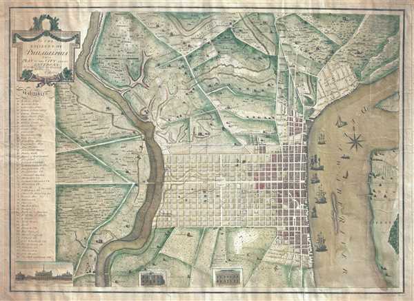
This is a 1796 Peter Charles Varlé city map or plan of Philadelphia, Pennsylvania. At this point in history, Philadelphia remained the capital of the United States, since the transfer to Washington, D.C. would not take place until 1800. The map depicts the city of Philadelphia from the Delaware River to the Schuylkill River and its environs. The city itself is shaded yellow with the built-up areas along the Delaware shaded red, which went against founder William Penn's desire to expand westward toward the Schuylkill. Individual streets are labeled, with High Street and Broad Street prominently illustrated, along with the public square at the center of town. Twenty-four different locations are identified alphabetically in a key on the left, with a further 27 locations, including banks and numerous churches, identified numerically. Individual homesteads are illustrated in the countryside on three sides of Philadelphia and are identified by the name of the residents, and in New Jersey on the opposite bank of the Delaware.
The map's charm is enhanced by the ships crowding Philadelphia's wharves along the Delaware. Several vignettes are situated along the bottom border, including City Hall, the State House, Congress Hall, the library, and the Bank of the United States.
This map was published in 1796 by Peter Charles Varlé in Philadelphia.
Cartographer
Peter Charles Varlé (also known as Charles Peter Varlé (c. 1770 - 1835) was a French draughtsman, cartographer, and engineer active in the United States. He was born in toulouse in southern France and left France for Hispaniola (Santo Domingo) at the beginning of the French Revolution. He lived on Hispaniola and worked as an engineer until 1794, when he was forced to flee by the uprising of 1794. He moved to the United States and published a renowned plan of Philadelphia in 1796, along with a second edition in 1802. Varlé lived in Maine in 1795, and later in Massachusetts. He again lived in Philadelphia from 1797-98, and then moved to Baltimore, where he spent the rest of his days, except for time spent in Philadelphia in 1802. More by this mapmaker...
Condition
Very good. Blank on verso.