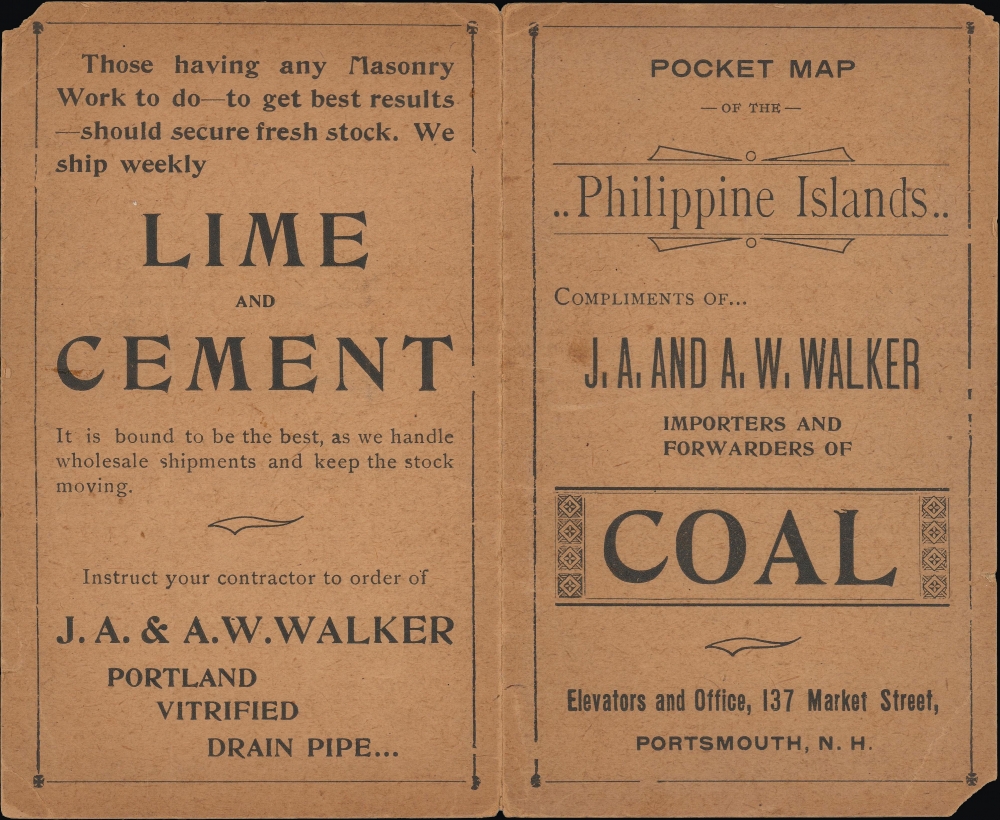
A rare c. 1899 pocket map of the Philippines or Philippine Islands coinciding with the American occupation of the archipelago and the resulting conflict with Filipino independence fighters. It was published in Chicago by the Fort Dearborn Publishing Company and issued on behalf of a local business in Portsmouth, New Hampshire.
A Closer Look
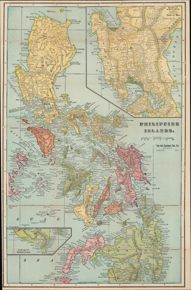
Coverage includes the entire archipelago from northern Luzon to southern Mindanao and from Palawan to the Pacific. Settlements, islands, mountains, waterways, shipping routes, and other features are indicated throughout. A railway between Manila and Dagupan, the only intercity railway in the archipelago built by the Manila Railway Company in the preceding decade, is outlined in black. An inset in the upper right focuses on the 'seat of the war' on Luzon in the vicinity of Manila Bay, while a small inset at bottom-left includes the southern portion of Mindanao.The Philippine-American War
The Philippine-American War lasted from February 4, 1899, until July 2, 1902, when the Philippine Organic Act established the Second Philippine Commission and Philippine legislature. The war immediately followed the Spanish-American War, once the Filipinos realized that the Americans were in the islands to stay. The Philippine people were doubtless happy to be rid of the Spanish, which they had been actively revolting against since 1896, but did not want another colonial overlord in the form of the United States, and so the struggle for independence continued.
Estimates of Filipino civilian casualties vary wildly, from at least 200,000 to over one million, the majority of which were caused by famine and disease. The war was notable for multiple instances of well-documented atrocities, embodied by one American general's order to 'kill everyone over the age of ten,' and led to considerable debate and discomfort in the United States. Armed resistance to the U.S. occupation of the Philippines continued as a guerrilla insurrection in many parts of the archipelago until June 1913. The U.S. passed the Tydings-McDuffie Act, also known as the Philippine Independence Act, in 1934. This law created the Commonwealth of the Philippines, increased self-governance, and scheduled Philippine independence for 1944. World War II delayed this process, and the U.S. did not grant full independence to the Philippines until 1946.Publication History and Census
This separately-issued pocket map was published in Chicago by the Fort Dearborn Publishing Company and distributed to various businesses for use as a kind of calling card. Though not noted here, it is based on that by George Cram that appeared in his National Standard Atlas of the World. The present example was issued on behalf of J.A. and A.W. Walker, of Portsmouth, New Hampshire, whose advertising and branding appear on the cardboard folio into which the map folds. The folio advertises the Walkers' business as not only importers and forwarders of coal, but also as purveyors of materials for masonry and carpentry work. We are aware of other variants of the map issued for Harper and Googin of Lewiston, Maine, importers of Asian hardwoods from the Philippines; the Capital Fire Insurance Company of Concord, New Hampshire; Vermont Fancy Butterine syrup; and the Northwestern Yeast Co. of Philadelphia. In these various issues, the map is held by seven institutions in North America.
CartographerS
The Fort Dearborn Publishing Company (fl. c. 1893 - 1905) was an American publishing firm based in Chicago, Illinois. The firm published atlases, books, cookbooks, and separate maps. John F. Waite served as the president from at the latest 1896 until at least 1903 and the firm operated out of 415 and 417 Dearborn Street in Chicago. More by this mapmaker...
George Franklin Cram (May 20, 1842 - 1928) was an American map publisher active in the late 19th and early 20th centuries. During the American Civil War, Cram served as a staff cartographer for the Union General Ulysses S. Grant and participated in Sherman's 'March to the Sea'. In 1867, after being discharged from the army George Cram moved to Chicago, where he founded 'Blanchard and Cram' with his uncle Rufus Blanchard Evanston. Blanchard and Cram was a supply house for the book trade - though he also published a few maps during this period. This short lived business was destroyed in the 1871 by Great Chicago Fire. After the fine, recognizing a business opportunity in the burgeoning railroad industry, Cram reinvented himself as cartographic publisher, opening the Cram Map Depot. Like fellow Chicago publisher Rand McNally, Cram took advantage of economical wax engraving processes to inexpensively produce maps in vast quantities. His signature publication, the Unrivaled Atlas of the World became the world's best -selling atlas and was published from the 1880s to 1952. On retiring in 1821 Cram sold his company to E. A. Peterson of the National Map Company (Scarborough Company). Peterson moved the company to Indianapolis where, following Cram's death, he rebranded the National Map Company as the George F. Cram Company, surely thinking to capitalize on the established identity of the firm. In 1930 he entered the globe market for which the firm was best known from the mid-20th century. In time the firm expanded globally passing becoming a major concern. By 2012, however, they were out of business. Learn More...
Very good. Light wear along original fold lines. Verso repairs to fold separations and at fold intersections. Reinforcement where previously attached to binder. Accompanied by original binder.
OCLC 56019852. Rumsey 3200.002.