1751 Anson Chart of Map of the Philippines
Philippines-anson-1751$1,000.00

Title
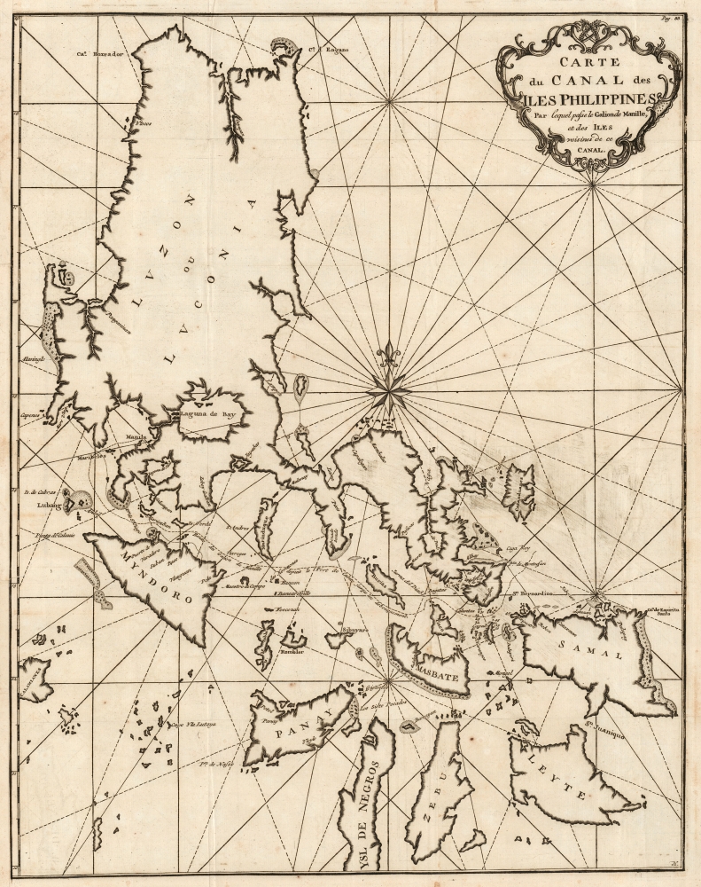
Carte du Canal des Iles Philippines Par lequel passe le Galion de Manille, et des Iles voissins de ce Canal.
1751 (undated) 20.75 x 16.25 in (52.705 x 41.275 cm) 1 : 1674000
1751 (undated) 20.75 x 16.25 in (52.705 x 41.275 cm) 1 : 1674000
Description
This is the 1751 edition of British circumnavigator and George Anson's most important published map, his nautical chart of the Philippines. Anson's 1744 swashbuckling voyage was celebrated, and his maps were reproduced in various editions and in several languages. This one, included in the French edition of Anson's Voyage published by Amsterdam and Leipzig publishers Arkstée and Merkus, is the most attractive, with bold engraving, a superb compass rose, and a rococco cartouche crowned with laurels.
Scope
The map covers the northern Philippine Islands from Cebu to the northern tip of Luzon. It is intended to illustrate the track taken by the Spanish treasure ships as they left Manila bound for the Americas; the track is shown leaving Cavite and threading the strait above Mindoro, passing below Marinduque and Burias, above Tiaco, then past Capul and the San Bernardino Islands before heading out to the Pacific just north of Samal.A Celebrated Venture
In 1740, during the War of Jenkin's Ear (1739 - 1748), Anson lead an ill-equipped expedition into the Pacific with the mission to attack Spanish dominions in South America. Though he failed in that mission, Anson did succeed in capturing the Spanish treasure galleon Nostra Seigniora de Cabadonga off Cape Espiritu Santo on June 20, 1743. The Spanish galleon was loaded with gold, silver and, more importantly, nautical charts depicting the trade routes used by Spanish Galleons between Mexico and Manila for the previous 200 years. This significant discovery allowed the British to disrupt Spain's trade in the Pacific and thus economically handicap the Spanish dominance of the New World. Following his capture of the Nostra, its treasures were paraded through the streets of London in no less than 32 wagons. Anson was hailed as a national hero, and the publication of his exploits by Anson's ship's chaplain Richard Walter in A Voyage Round the World would spread his fame throughout Europe.Publication History and Census
This map was engraved for inclusion in the 1751 Arkstée and Merkus French edition of Anson's Voyage autour du monde. Although the Amsterdam/Leipzig publishing house produced a 1749 edition, its version of this map was a simpler engraving on a different plate; this plate appears in no later editions. We see no examples of this separate map cataloged in institutional collections; the full text appears in seventeen citations in OCLC.Cartographer
Baron George Anson (23 April 1697 - 6 June 1762) was a British commodore and a wealthy noble. Following Anson's aristocratic upbringing on the family estate of Shugborough in Sataffordshire, he joined the British Navy. Anson went through a series of rapid promotions and, in 1737, was given command of a fleet of six ships charged with the mission of attacking Spanish possessions in South America. This mission was ill-equipped and unprepared for the trials ahead. Storms and navigational errors took a heavy toll on the expedition. By the time Anson reached the island of Juan Fernandez his fleet had been diminished to only three ships and his crew reduced to roughly 1/3 of its original strength. Nonetheless, Anson's persistence eventually led to the capture of an immensely rich price, the Spanish treasure galleon Nuestra Senora de Covadonga. The galleon, taken off of Cape Espiritu Santo in 1743 was loaded with silver bullion and, more importantly, charts and maps detailing the routes between Mexico and the Far East used by the Spanish for over 200 years. Knowledge of this route enabled the British navy to disrupt Spanish trade in the Pacific and thus weaken its stranglehold on the Americas. Upon his return to England Anson was hailed as a national hero and made immensely wealthy by his share of the Nuestra's treasure. Anson retired from the Navy for a career in politics and was a Member of Parliament from 1744 to 1747. Anson subsequently continued his naval career with distinction as an administrator, becoming First Lord of the Admiralty (1757-1762). Seven British warships have borne the name HMS Anson in his honor. Anson County, North Carolina, and Ansonborough in Charleston, South Carolina, are also named in Anson's honor. More by this mapmaker...
Source
Anson, George and Walter, Richard, Voyage autour du monde, (Amsterdam and Leipzig: Chez Arkstée and Merkus) 1751.
Condition
Excellent. Margin reinstated at insertion point with no loss; else fine with a bold, sharp strike.