1965 Derdeyn Pictorial Map of the French Quarter (Vieux Carre), New Orleans
PictorialFrenchQuarter-derdeyn-1965$250.00

Title
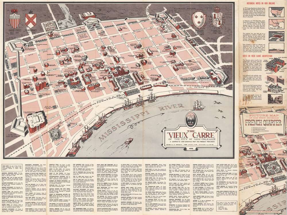
The Vieux Carré of the City of New Orleans: a Composite View Showing Past and Present Features. Picture Map of the New Orleans French Quarter.
1965 (dated) 17.5 x 23.5 in (44.45 x 59.69 cm)
1965 (dated) 17.5 x 23.5 in (44.45 x 59.69 cm)
Description
This is a 1965 Eugene Derdeyn pictorial map of the French Quarter, or Vieux Carré, in New Orleans, Louisiana. The map overlooks the French Quarter, the oldest neighborhood in New Orleans, from above the Mississippi River. Historic and contemporary buildings appear side by side pictorially. The city's fortifications appear as well, with sites of the original bastions emphasized. Riverboats and multi-masted sailing ships are docked along the riverbank. The coats of arms of France, Spain, the Confederacy, and the United States appear along the top border. A short history of the Quarter and its architecture are situated to the right, while an alphabetic index is situated at bottom.
Publication History and Census
This map was created and published by Eugene Derdeyn in 1965. We note three examples cataloged in OCLC which are part of the collections at the University of Illinois at Urbana Champaign, the Newberry Library, and the Historic New Orleans Collection. Cataloging in OCLC suggests there may be a 1966 edition as well.Condition
Good. Wear along original fold lines. Light soiling. An area of dampstaining. Slight loss at a few fold intersections.
References
OCLC 1023656757.