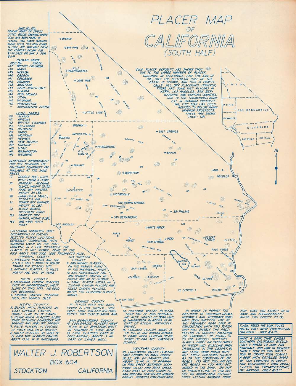
This is a c. 1956 Walter J. Robertson diazootype map of southern California placer gold and uranium deposits. Coverage extends from Bishop south to the border between California and Mexico and from Los Angeles east to the state border. Dotted circles mark gold placer deposits while 'UR' marks uranium. An index of eighteen locations along the bottom border provides information about these placer sites along with their relative position. Text at left promotes some of Robertson's other maps.
Prospecting for Gold and Uranium
The gold rushes of the 19th century fostered the fantasy of 'striking it rich'. Even today, hobbyists pan for gold in California, the Yukon, and Colorado, among other sites. Robertson's map is part of this cultural niche. Intriguingly, Robertson doesn't limit his map to gold, but also includes uranium. Uranium prospecting became popular with the 1940s 'Atomic Craze' and continued until the late 1950s. The United States government, then stockpiling uranium, was happy to buy the mineral from private individuals. Tens of thousands poured into the American Southwest with Geiger counters in search of the elusive mineral. Few discoveries were made, but those that managed to find worthwhile deposits made millions, encouraging others. Popular magazines, including Life, Boy's Life, and Popular Mechanics, published articles about uranium prospecting. A board game called 'Uranium Rush' was released in 1958 and there were even movies made about uranium prospecting. By the early 1960s, the U.S. government had enough uranium stockpiled which caused the price of uranium to crash, effectively ending the fad. Unfortunately for many of these prospectors, the effects of radiation were unknown at the time, causing many of these people to suffer cancers and other diseases later in life.Diazo Print or Whiteprint
The diazo print (whiteprint or diazo for short) is a photo reproductive technique best understood as a reverse cyanotype or blueprint. The process yields distinctive blue lines on white paper. Like cyanotypes, the diazo process gained popularity in architecture circles, where it was a simple and effective way to duplicate documents in the field. The earliest diazotypes appeared around 1880 and were adopted for military and field cartographic use from about 1895. The diazo process was commercialized in 1923, when the German firm, Kalle and Company, developed Ozalid, a patented diazo paper that made diazotyping even easier. By the 1950s, it supplemented cyanotypes as the reprographic technique of choice for technical drawings.Publication History and Census
This map was created and published by Walter J. Robertson c. 1956. Since this piece is undated, we used the 1954 publication date of Let's Go Prospecting by Edward Arthur as our point of reference. This is the only known cataloged example.
Cartographer
Walter James Robertson (October 2, 1910 - May 9, 1978) was an American publisher and cartographer. Born in Colorado, Robertson lived most of this life in Stockton, California. Beginning in the 1950s (or possibly earlier), Robertson began publishing materials dealing with mining, including a pamphlet titled 'Gold Panning for Profit'. He also published a series of placer mining maps of several western states, including Oregon, Arizona, and Northern and Southern California. More by this mapmaker...
Very good. Cyanotype. Closed margin tears professionally repaired on verso.