
Robertson, Walter James

Walter James Robertson (October 2, 1910 - May 9, 1978) was an American publisher and cartographer. Born in Colorado, Robertson lived most of this life in Stockton, California. Beginning in the 1950s (or possibly earlier), Robertson began publishing materials dealing with mining, including a pamphlet titled 'Gold Panning for Profit'. He also published a series of placer mining maps of several western states, including Oregon, Arizona, and Northern and Southern California.
Hobbyist gold prospectors.
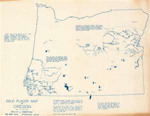
This is a c. 1956 Walter J. Robertson map of Oregon illustrating placer gold deposits. Dashed lines encircle the two principal gold districts: one in eastern Oregon and one in southwestern Oregon near the California border. Deposits are marked by clusters of blue dots. Rivers, creeks, and major cities and towns near these deposits are illustrated and labeled. Apart from these two regions, very little detail appears. Major lakes are depicted, including Crater Lake and Upper Klamath Lake. A few cities outside the gold-producing regions are noted, such as Portland, Albany, and Corvallis. (more details)
Prospect for gold in Arizona!
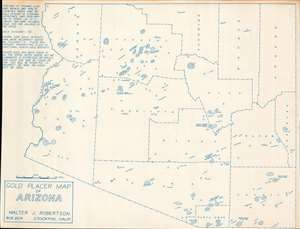
This is a c. 1956 Walter J. Robertson diazotype map of Arizona placer gold deposits. Circular areas of dots mark placer deposits, some of which are annotated with the value of nuggets discovered. Capital 'G's mark known lodes (which require underground mining and are much less likely to be attractive to prospectors). Although the Arizona gold rushes predate this map by decades, or even a century, prospectors continued to explore to this day. Robertson created this map, along with maps of other states where there were placer gold deposits, for those individuals. (more details)
Mine gold in Nevada!
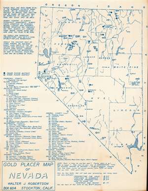
This is a c. 1956 Walter J. Robertson diazotype map of Nevada's placer gold deposits. Fifty-eight locations where placer gold was discovered are numerically identified throughout and correspond with an index in the lower-left. Some deposits are embellished with short comments. Among these are Site 58, which includes the caption 'a 24-pound nugget was found in Dry Gulch!', and Site 14, which notes that 'a 9-pound nugget found here'. Robertson includes a note about other gold mining and prospecting literature he has for sale along the bottom border, including four books about gold prospecting, such as 'Confidential Tips on Placer Mining in Nevada'. (more details)
Hunt for gold in northern California!
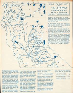
This is a c. 1956 Walter J. Robertson diazotype map of northern California placer gold deposits. Dotted lines outline regions where placer gold had been discovered: one in northwestern California and another along the western slopes of the Sierra Nevada Mountains. Dots line the banks of numerous rivers, illustrating where individuals hunting for gold might have some luck. Apart from these important rivers, very little else is illustrated here. Robertson states that this was a choice he made 'in the interest of clarity'. (more details)
Gold and uranium prospecting.
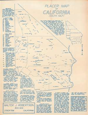
This is a c. 1956 Walter J. Robertson diazootype map of southern California placer gold and uranium deposits. Coverage extends from Bishop south to the border between California and Mexico and from Los Angeles east to the state border. Dotted circles mark gold placer deposits while 'UR' marks uranium. An index of eighteen locations along the bottom border provides information about these placer sites along with their relative position. Text at left promotes some of Robertson's other maps. (more details)