This item has been sold, but you can get on the Waitlist to be notified if another example becomes available, or purchase a digital scan.
1857 Vuillemin Case Map of the World on Mercator's Projection
Planisphere-vuillemin-1857$625.00

Title
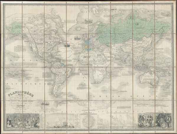
Planisphere Illustre presentant la description geographique des parties connues de la Terre. Indiquant l’epoque des grandes decouverts et le nom des navigateurs. Les Colonies des diverses nations ainsi que la parcours des bateaux a vapeur, l’ epoque des departes la duree du trajet & c. dresse par Vuillemin geographe. (Famous World Map presenting the geographical description of the known parts of the Earth. Indicating the time of great discoveries and the name of the navigators. The Colonies of the various nations as well as the course of steamers, the times departure and the duration of the journies, etc. Drafted by Vuillemin Geographer.)
1857 33.5 x 45 in (85.09 x 114.3 cm)
1857 33.5 x 45 in (85.09 x 114.3 cm)
Description
This is a rare and magnificent 1857 case map of the world on Mercator's projection by French cartographer Alexandre Vuillemin. Depicts the world in extraordinary detail with numerous decorative embellishments and prolific notations. Map offers nothing short of 11 decorative vignettes ranging from whaling ships at sea, to Eskimos hunting in the arctic, to armies of horsemen battling across the Sahara. In the American Northwest, some of Lewis and Clarks recent discovers are noted and there is some attempt to notate the various American Indian tribes of the region. The ice flows of both the arctic and Antarctic are decoratively and beautifully rendered in profile. Nautical routes between major cities are noted. There are also innumerable historical and textual notations throughout the map. Bottom portion of the map has two engravings depicting the traditional consumes of the various world cultures, as well as statistical information on the worlds rivers, mountains, and climate. All text is in French. A much smaller and edited down version of this map was published in Vuillemin'simportant Atlas Illustre de Geographie Commerciale et Industrielle. Edited by Fatout o Boulevard Poissoniere, no 17, Paris.
Cartographer
Alexandre Aimé Vuillemin (1812 - 1880) was an engraver, publisher, and editor based in Paris, France in the middle of the 19th century. Despite a prolific publishing career, much of Vuillemin's life is shrouded in mystery. In 1852, he married Josephine Caroline Goret and they had at least one child, Ernestine Adèle Vuillemin, later in the same year. What is known is that his studied under the prominent French Auguste Henri Dufour (1798 - 1865). Vuillemin's most important work his detailed, highly decorative large format Atlas Illustre de Geographie Commerciale et Industrielle. More by this mapmaker...
Condition
Very good condition. Mounted on original linen in 32 folding sections.