This item has been sold, but you can get on the Waitlist to be notified if another example becomes available, or purchase a digital scan.
1852 Levasseur Map of the World
Planisphere2-levasseur-1853$200.00

Title
Planisphère.
1853 (undated) 16.5 x 12.5 in (41.91 x 31.75 cm) 1 : 150000000
1853 (undated) 16.5 x 12.5 in (41.91 x 31.75 cm) 1 : 150000000
Description
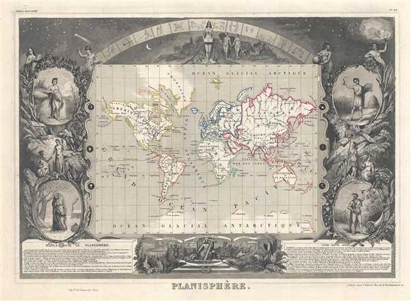
A visually stunning decorative map of the world dating to 1852, by French map publisher Victor Levasseur. Levasseur depicts the world on a Mercator Projection, showing the six known continents as well as traces of Antarctica. The cartographic style of this piece is minimalist, but a few elements do bear special note. These include the extension of Oregon territory well into British Columbia, reflecting the American claims that later led to the 54' 40' dispute. Also in North America, Texas is identified as an independent nation. Far to the north both the Northwest Passage over America and the Northeast Passage over Europe and Asia, are drawn as open and practically navigable waterways.
By far this map's most striking feature is its elaborate allegorical border work. Levasseur composed this map for publication in his magnificent Atlas Nacionale de la France Illustree, one of the most decorative and beautifully produced atlases to appear in the 19th century.
This particular map is surrounded by four medallions bearing allegorical representations of the seasons. Spring, in the upper left, is represented by a young unclothed woman modestly covering herself with garlands. Summer, in the lower right, is a powerful bearded man wearing an animal skin and surrounded by the bounty of life. Fall, upper right, is a young man reaping the harvest. And winter, lower left, is a huddled old woman in a barren snow covered setting.
Atop the map is an image of the firmament, with shooting starts, clouds, and a symbolic representation of the Zodiac. At center is a curious unclothed woman with four breasts who appears to be chained to the earth or to a heavy box which she is holding - Pandora? Adam and Eve appear to her right walking hand in hand through pre-fall Eden. There too is the serpent, slithering just behind the couple.
At the base of the map an even more interesting scene unfolds in the form of a curious panorama. Here Jesus sits enthroned, bearing a cross in his left hand and pointing with his right, his head surrounded by a pyramid (a Masonic reference?). To his left are a stoic crowd including Napoleon, Socrates, and other unidentifiable great men bearing signs reading 'Paix' (peace), 'Liber' (freedom), and 'Egalite' (equality). Behind them is a domed building that appears to be a Greek or Roman temple. Opposite this scene, on Jesus' right is a very different scene showing a crowd fleeing in terror - these include a Pharisee holding the Torah and a turbaned Saracen. Behind them are the pyramids of Egypt. They are running towards what appears to be the jungle where there is a plinth upon which sits a bust of Satan. In this we can only assume that Levasseur is attempting to convey the righteousness of reason and logic over emotion and old world superstition.
Published by V. Levasseur as page no. 95 in the 1853 edition of his Atlas National de la France Illustree.
Cartographer
Victor Levasseur (1800 - 1870), an important French engineer, cartographer, and engraver of the mid 19th century, held a number of important cartographically related political and educations posts in France. He is most famous for his Atlas National Illustré des 86 Départements et des Possessions de La France, a large decorative atlas of France, including his Planisphere and five important continental maps. Levasseur's maps are distinctive for their wide decorative margins containing elaborate depictions of the scenery, peoples, and trade goods of the areas he mapped. Levasseur maps are also known to offer a wealth of statistical data. Until recently, very few Levasseur Atlases migrated out of France where they were mostly used in public libraries and town halls. His work represents some of the last great decorative atlases of the 19th century. More by this mapmaker...
Source
Levassuer, V., Atlas National Illustre des 86 Departements et des Possessions de La France Divise par Arrondissements, Cantons et Communea avec La Trace de Toutes Les Routes, Chemins,de fer et Canaux., 1852 edition.
Condition
Very good. Blank on verso.
References
Phillips (Atlases) 3003.