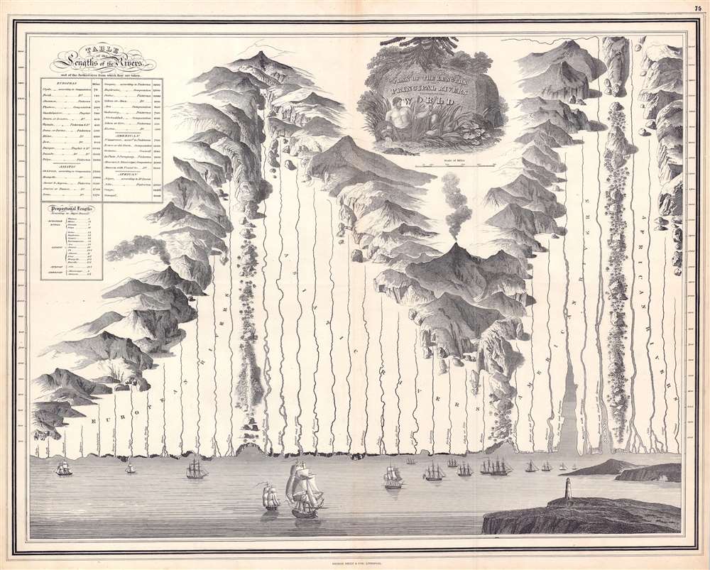
This is a c. 1830 George Philip and Son comparative chart of the world's rivers. Divided geographically, the world's rivers fall into four groups: European, Asian, American, and African. Philip employs boulders, ridges, forests, and mountain ranges to divide the groups. The rivers originate in fantasy mountain ranges. All the rivers empty into a sea along the bottom of the chart. Here, it is worth noting that Philip also pays close attention to the mouths of the rivers and illustrates their deltas in some detail. Among these are the Rhine, Volga, Indus, Niger, and Nile. The mouths of the Amazon and the Rio de la Plata receive exceptional treatment. Numerous sailing ships ply the waters of this vast imaginary sea and a lighthouse occupies a point of land in the foreground on the right. A table situated in the upper left provides the length of each river in miles. A smaller table compares the length of the Thames (an English reader's likely point of reference) with that of other world rivers and states that the Amazon is over fifteen times as long.
The Comparative Chart
The convention of the comparative geographical chart represents 19th-century scientific idealism at its best. Comparative charts of relative mountain heights began appearing in the early 19th century, with Carl Ritter, Christian von Mechel, and Robert Andrew Riddell all publishing charts of their own design in the first decade of that century. Following the influential 1809 South American mountain profiles issued by the Prussian naturalist Alexander von Humboldt, the 'mountain tableaux' became much more popular. Around the same time, comparative river length charts also began to be issued. The convention initially involved separate charts, but design ingenuity soon began synthesizing mountain and river diagrams into a single dynamic chart.Publication History and Census
This chart was published by George Philip and Son c. 1830. It is not cataloged in OCLC and we are aware of only two other examples, both in private hands.
Cartographer
George Philip (1800 - 1882) was a map publisher and cartographer active in the in the mid to late-19th century. Philip was born into a Calvinst family in Huntly, Aberdeenshire, Scotland. Around 1819 he apprenticed himself to William Grapel, a Liverpool printer and bookseller. Fifteen years later, in 1834, Philip founded his own Liverpool book and map firm. Philip's earliest cartographic ventures were mostly educational material issued in tandem with John Bartholomew Sr., August Petermann and William Hughes. In 1848, Philip admitted his son, George Philip Jr. (1823 - 1902) into the firm, renaming it George Philip & Son Ltd. George Philip Jr. ran the firm until his death in 1902 by which time it had developed into a major publishing concern. His successors established the London Geographical Institute, a factory where they embraced modern printing techniques to produce thousands of economical and high quality maps. In April of 1988, George Philip & Son was acquired by Octopus Publishing, a branch of Reed International. Nonetheless, today the firm trades and publishes to this day as George Philip and Son. More by this mapmaker...
Very good. Exhibits light wear along original centerfold. Blank on verso.