1854 Longuet Map of the Eastern Balkans and Black Sea During the Crimean War
ProvincesDanubiennes-longuet-1854$950.00

Title
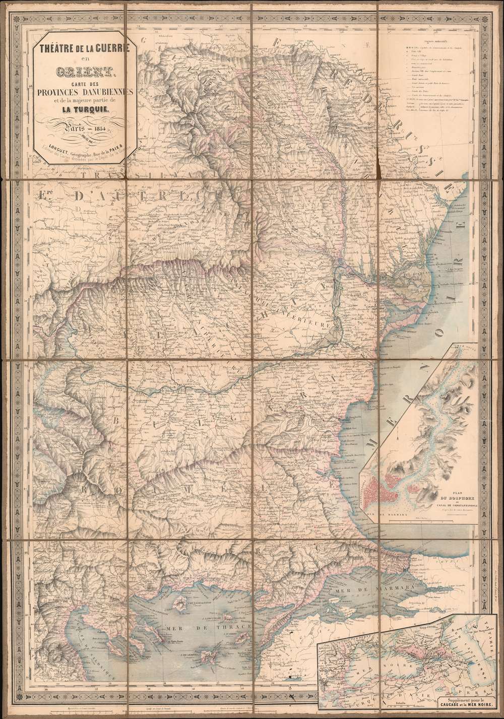
Théâtre de la Guerre en Orient. Carte des Provinces Danubiennes et de la majeure partie de la Turquie.
1854 (dated) 33 x 23 in (83.82 x 58.42 cm) 1 : 1390000
1854 (dated) 33 x 23 in (83.82 x 58.42 cm) 1 : 1390000
Description
This is an 1854 Longuet map of the eastern Balkans and the Black Sea. The map depicts the region from Transylvania and Thessaly to Odessa and from the Dnister (Dniester) River to Lemnos. Published in the middle of the war, areas occupied by the Russians at the beginning of the war by the Russian Empire (Wallachia and Moldavia) are highlighted, allowing the audience back in France a better understanding of where their army had been committed.
Highly detailed, myriad cities, towns, and villages are labeled, including Odessa, Istanbul/Constantinople, Salonica, and Gallipoli. Three different grades of roads are illustrated, with different notations used to differentiate between them. An inset map situated along the right border details the Bosporus from the Sea of Marmara and Constantinople/Istanbul to the Black sea. Depth soundings are indicated throughout the strait, and the city is highlighted by red shading. A second inset, located in the lower right corner, expands the breadth of the map and situates it regionally, stretching from the Balkans to the Caspian Sea.
Hostilities erupted in July 1853 when Russia invaded two Ottoman suzerainties known collectively as the Danubian Principalities, labeled here as Wallachia and Moldavia. The Ottomans immediately responded and fought a defensive campaign that eventually halted the Russian advance at Silistra, which the Russians besieged. Alarmed by the possibility of an Ottoman collapse, the British and French jumped to their aid, sending troops and supplies to Gallipoli. They did not arrive at Silistra until after the Russians had withdrawn.
Now, public opinion at home, where discontent at the seemingly wasted effort and expense of sending armies to the Balkans, exerted an influence on the alliance. This outcry led to the planning and execution of an invasion of the Crimean Peninsula in September and a siege of the Russian naval port of Sevastopol, their primary naval base in the Black Sea, which lasted for eleven months. Russia finally sued for peace in March 1856 and in the Treaty of Paris the ended the war Russia lost its Black Sea ports, Wallachia and Moldavia gained a modicum of independence, and Christians in the Holy Land were given a degree of equality.
Highly detailed, myriad cities, towns, and villages are labeled, including Odessa, Istanbul/Constantinople, Salonica, and Gallipoli. Three different grades of roads are illustrated, with different notations used to differentiate between them. An inset map situated along the right border details the Bosporus from the Sea of Marmara and Constantinople/Istanbul to the Black sea. Depth soundings are indicated throughout the strait, and the city is highlighted by red shading. A second inset, located in the lower right corner, expands the breadth of the map and situates it regionally, stretching from the Balkans to the Caspian Sea.
The Crimean War
The Crimean War, with an alliance of the Ottoman Empire, Britain, France, and Sardinia on one side of the conflict and the Russian Empire on the other, lasted from October 1853 until February 1856. The root cause of the war has never been fully understood, but the stated impetus for hostilities was the rights of Christians in the Holy Land, with the Catholics being supported by the French and the Greek Orthodox Church gaining the support of the Russians. Other factors also included the gradual decline of the Ottoman Empire and British and French concerns about Russian gains in the region at the cost of the Ottomans.Hostilities erupted in July 1853 when Russia invaded two Ottoman suzerainties known collectively as the Danubian Principalities, labeled here as Wallachia and Moldavia. The Ottomans immediately responded and fought a defensive campaign that eventually halted the Russian advance at Silistra, which the Russians besieged. Alarmed by the possibility of an Ottoman collapse, the British and French jumped to their aid, sending troops and supplies to Gallipoli. They did not arrive at Silistra until after the Russians had withdrawn.
Now, public opinion at home, where discontent at the seemingly wasted effort and expense of sending armies to the Balkans, exerted an influence on the alliance. This outcry led to the planning and execution of an invasion of the Crimean Peninsula in September and a siege of the Russian naval port of Sevastopol, their primary naval base in the Black Sea, which lasted for eleven months. Russia finally sued for peace in March 1856 and in the Treaty of Paris the ended the war Russia lost its Black Sea ports, Wallachia and Moldavia gained a modicum of independence, and Christians in the Holy Land were given a degree of equality.
Publication History and Census
This map was published by Longuet in 1854. The OCLC catalogues three examples as being part of the institutional collections at the Bibliothèque national de France, Harvard, and the National Library of Poland.Condition
Good. Dissected and mounted on linen in sixteen panels. Wear along original fold lines. One area of loss to upper right panel. Blank on verso.
References
OCLC 495042483.