Title
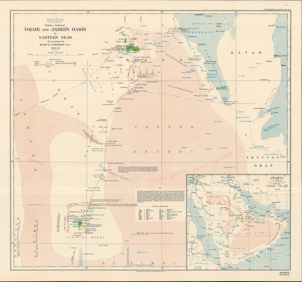
Arabia Routes between 'Oqair and Jabrin Oasis in Eastern Nejd.
1925 (dated)
19 x 20 in (48.26 x 50.8 cm)
1 : 750000
Description
An impressive 1925 map recounting the incredible journey of R. E. Cheesman, the first European to cross the 'Great Desert' or 'Empty Quarter' (Rub' al Khali) in eastern Arabia. Based on Cheesman's surveys, the map appeared in conjunction with an article penned by him that appeared in The Geographical Journal.
A Closer Look
Covering a portion of eastern Arabia with Qatar, the map traces the route of Cheesman and his team (with dates noted) from 'Oqair on the Persian Gulf to Hufuf and across a vast desert to the oasis at Jabrin. Caravan routes and the paths of other recent European explorers who crossed the Arabian Peninsula without daring enter the Great Desert are also traced (St John Philby, mentioned here, did cross the Rub' al Khali in the early 1930s and mapped much of its southern portion). Comments on terrain, water sources (supposed and confirmed), elevation, and other features appear throughout.
Incidentally, Ghawar, southwest of Hufuf, was discovered to hold vast oil reserves in the late 1940s. Since that time, it has been the largest conventional oil field in the world and accounts for about one-third of Saudi Arabia's oil production.
A note on the map's production and an Arabic-English glossary appear at bottom towards right. At bottom-right is an inset of the wider region, indicating Cheesman's route, railways (including the Hejaz Railway and the Baghdad-Basra Railway), major cities, territories and kingdoms, waterways, and more. Chessman's Explorations
Though less well-known than some of his contemporaries, Cheesman's explorations were nonetheless important to the survey and mapping of the coasts of the Gulf of Salwah and of the 'Great Desert'. He led two important expeditions in the region. First, in 1921, he and a team journeyed down the coast of the Gulf of Bahrain from 'Oqair (Al Uqayr) to Salwah, an area which had never been mapped and only scarcely seen by Europeans before. Despite having a dhow full of supplies shadowing the trekking party down the coast, there were still harrowing moments when food and water nearly ran out, as coordination with the supply ship was difficult. Aside from cartographic work, Cheesman's main purpose was to examine archeological ruins, and search for the Phoenician city of Gerrha described in ancient sources as fabulously wealthy. He was also curious about the routes of migratory birds in the region.
Then, in November 1923, Cheesman set out on a more ambitious and dangerous expedition into the Arabian interior (traced here). Again, he received permission and support from his commanding officer, Sir Percy Cox, as well as the Sultan of the Nejd, Abdulaziz ibn Saud, later the first king of Saudi Arabia. Again, the main purpose of the expedition was ostensibly ornithological, but Cheesman's expertise in several fields naturally led to a range of discoveries. Setting out from 'Oqair, the first part of the journey covered the relatively easy, though still novel to Europeans, path to Hufuf. South of Hufuf, however, was a vast area known to Europeans as 'Unknown Arabia' or the 'Great Desert,' and to Arabs as Rub' al Khali (the 'Empty Quarter'), defined by large sand dunes and occasional mountains (Westerners, including Percy Cox, had only seen the region from a distance).
Cheesman was accompanied by a young Baghdadi who he had known for several years and who had trained as a taxidermist at the British Museum, as well as local guides who had a sense of potential water sources. After reaching Hufuf, the party waited more than two months to assess whether rains would be sufficient to fill wells believed to be along the route southwards to Jabrin. In addition to the elements, Cheesman was also warned that he might be attacked by Al Murrah nomads, who were dissatisfied at having been recently conquered by the House of Saud. But Cheesman was helped in this regard and others by the fact that one of his guides was himself Al Murrah.
Once moving again in mid-February, the party made rapid progress through the desert and was fortunate in finding water. They reached Jabrin on February 17 and were feted by the local sheikh. After resting for several days, they set out for the return journey to Hufuf, arriving on March 1, and then completing the return to 'Oqair on March 5. Through his journey, Cheesman was the first European to witness the Wadi Sahba and many other features in the 'Great Desert.'Publication History and Census
This map was based on surveys undertaken by R. E. Cheesman and was published to accompany his article 'The Deserts of Jafura and Jabrin' in the February 1925 issue of the The Geographical Journal. It was republished the following year in Cheesman's book In Unknown Arabia (London: Macmillan, 1926). The map is independently cataloged among the holdings of Stanford University, the Library of Congress, the British Library, New York University, NYU Abu Dhabi, and the University of Oxford.
CartographerS
Robert Ernest Cheesman (1878 - February 13, 1962) O.B.E., was a British military officer, explorer, diplomat, and ornithologist, known especially for his work in the Arabian Peninsula. Cheesman's exposure to the Middle East began when he was assigned as Private Secretary to Sir Percy Cox during and after the First World War, including the first part of his tenure as High Commissioner in Iraq (beginning in 1920). Cheesman quickly developed knowledge and connections throughout the region, including befriending Shaikh Hamad bin Isa Al Khalifa (1872 - 1942) of Bahrain, who later became hakim (ruler) of Bahrain. Between 1921 and 1924, Cheesman explored and mapped the Arabian coast from the Gulf of Salwah to Uqair while also collecting hundreds of specimens from the Al-Ahsa Oasis. His sister, Evelyn, an entomologist, accompanied him on these explorations and also collected many specimens for scientific study, while another sister, Edith, was a painter known for her depictions of Iraq. After his work in Iraq and Arabia, R. E. Cheesman began a diplomatic career, stationed for a decade as a consul at Dangila in northwest Ethiopia. While there, he mapped the regions of Agawmeder and Gojjam, and explored and surveyed parts of the Blue Nile and Lake Tana. For these latter explorations, he was awarded the Royal Geographical Society's Patron's Medal. Cheesman retired from diplomatic service in 1934, but rejoined the military during the Second World War and was made the head of intelligence for the Ethiopian Section of the Sudan Defence Force. More by this mapmaker...
Royal Geographical Society (fl. 1830 - present) is a British Society established in 1830 to promote geographical science and exploration. Originally titled the "Geographical Society of London", the RGS received its royal charter from Queen Victoria in 1859 shortly after absorbing several similar but more regional societies including the African Association, the Raleigh Club and the Palestine Association. The RGS sponsored many of the most important and exciting voyages of exploration ever undertaken, including the exploration of Charles Darwin, David Livingstone, Robert Falcon Scott, Richard F. Burton, John Speke, George Hayward, H. M Stanley, Ernest Shackleton and Sir Edmond Hillary. Today, the RGS remains a leading global sponsor of geographical and scientific studies. The Society is based in Lowther Lodge, South Kensington, London. Learn More...
Source
Cheesman, R. E., Maj., 'The Deserts of Jafura and Jabrin', The Geographical Journal, Vol. LXV No. 2 February (London: Royal Geographical Society, 1925).
Condition
Very good. Left margin trimmed for folding into volume.
References
OCLC 861733570, 1333209926.