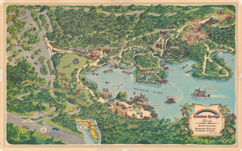
1967 Pictorial View of Rainbow Springs, Florida
RainbowSprings-unknown-1967$500.00


Title
Rainbow Springs, Florida.
1967 (undated) 20.5 x 33.5 in (52.07 x 85.09 cm)
1967 (undated) 20.5 x 33.5 in (52.07 x 85.09 cm)
Description
A colorful large-format c. 1967 pictorial view of Rainbow Springs, Florida, a former and popular nature themed park.
A Closer Look
This view provides an overview of the Rainbow Springs theme park, situated at the springs which form the headwaters of the Rainbow River. Perfectly situated along U.S. Highway 41 (with an attention-grabbing fountain at the entrance), the springs and related attractions drew seasonal tourists and migrants heading to Tampa. The park's various sections, from parking, security, and a monorail ('forest flight') to several animal parks, a waterfall, and a riverboat are displayed. The glass-bottomed 'Underwater Cruise,' allowing for viewing of the marine life of the springs, was especially popular.Rainbow Springs
Rainbow Springs is a first-magnitude artesian spring located just outside Dunnellon in Marion County, Florida. Both the springs and eponymous river were renamed (from Blue Springs and Blue Run, respectively) in the 1930s when they were developed for tourism (the nature park opened in 1939). Along with other springs, such as Silver Springs (about 25 miles to the northeast), and similarly themed animal parks, Rainbow Springs hoped to draw tourists traveling along the newly completed highway network of Florida, in this case U.S. Highway 41. These theme parks hosted kitschy but wildly popular attractions such as mermaid shows, glass bottom boats, and alligators. With the completion of Interstate 75, a faster route to Tampa, the number of visitors declined and Rainbow Springs closed in 1974. However, in the following years, the springs and adjoining lands were gradually protected and converted into a state park.Publication History and Census
This pictorial map was drawn by an unknown artist and was likely distributed to visitors to the park. It is undated, but the presentation of highways in the inset highway map of Florida at bottom suggests a date in the mid-late 1960s. The only institution to hold this map is the Touchton Map Library at the Tampa Bay History Center.Condition
Average. Wear along fold lines, with some loss at intersections. Pinholes, abrasion, discoloration, and some loss in margins due to earlier display / matting.
References
Touchton Map Library Accession Number 2018.091.031.