This item has been sold, but you can get on the Waitlist to be notified if another example becomes available, or purchase a digital scan.
1854 Blake Geological Map of Texas from the Red River to the Rio Grande
RedRiverRioGrande-blake-1854$325.00

Title
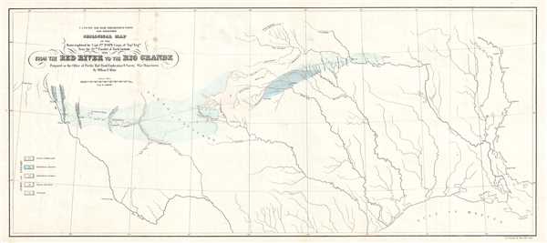
Geological map of the route explored by Capt. Jno. Pope, Corps of Topl. Engrs. near the 32nd parallel of north latitude, 1854.
1854 (dated) 10.5 x 23.5 in (26.67 x 59.69 cm) 1 : 3000000
1854 (dated) 10.5 x 23.5 in (26.67 x 59.69 cm) 1 : 3000000
Description
This is an 1854 William Phipps Blake geological railroad survey map of Texas from the Red River to the Rio Grande River. The map depicts from the Rio Grande River and El Paso to the Mississippi River and Baton Rouge and from the Red River and its tributaries to the Gulf of Mexico. Following the route for the Southern Pacific Railroad explored by Captain John Pope, from Preston to Fort Bliss, Texas, several different geological features are detailed. An 'index of colors' along the left border illustrates the differences between the deposits: granite, limestone, sandstone, gypsum, and others. Copper mines, several mountain ranges, forts, and myriad rivers are labeled.
This map was created by William Phelps Blake and printed by P.S. Duval and Son of Philadelphia for the U.S. Pacific Rail Road Exploration and Survey by the War Department in 1854. We have found some institutional references, but in general, this map is quite rare, with limited presence on the market over the past 30 years.
This map was created by William Phelps Blake and printed by P.S. Duval and Son of Philadelphia for the U.S. Pacific Rail Road Exploration and Survey by the War Department in 1854. We have found some institutional references, but in general, this map is quite rare, with limited presence on the market over the past 30 years.
CartographerS
William Phipps Blake (June 1, 1826 – May 22, 1910) was an American geologist, mining consultant, and educator. Blake has been credited with being 'the first college trained chemist employed full-time in American industry' before graduating from Yale. Selected as the mineralogist and geologist of the Pacific Railroad Exploring Expedition in 1853, Blake made several important discoveries, including studying the erosive effects of wind-blown sand in San Gorgonio Pass in California. Several of the sketches he produced for the Railroad Survey reports are not highly sought after as works of art. Over the course of his career, Blake served in several different official government posts, including as the California representative to the Exposition Universelle in Paris in 1867 and to collect and install the mineral exhibit at the Philadelphia Centennial Exposition. Blake also became a sought-after expert witness for testimony in court cases involving the geology of mineral deposits. His final stop in a long an illustrious career was at the University of Arizona, where he served as a Professor of Geology and as Director of the School of Mines. More by this mapmaker...
Peter Stephen Duval (1804 - February 8, 1886) was a prominent Philadelphia lithographer. He immigrated to Philadelphia from France in 1831 to take a job as a lithographer at the Philadelphia firm owned by Cephas Childs. In 1837, Childs retired and Duval took over the business. Over the course of the next thirty years, Duval would have several business partners including the Swiss-American engravers Charles and Frederick Bourquin (1808 - 1897). In 1857 his son Steven C. Duval joined the business. Peter Duval retired in 1869 but continued to be involved in his company until his death in 1886. Learn More...
Condition
Very good. Minor verso repair of a fold separation. Light soiling. Blank on verso.
References
OCLC 50701416.