Digital Image: 1924 S.T.C.R.P. Map of Organized Bus Trips Around the Paris Region
RegionParisienneAutocars-stcrp-1924_d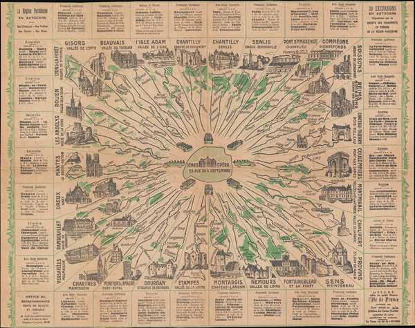

Title
La Région Parisienne en Autocars: 30 Excursion en Autocars Organisées par la Société des Transports en Commun de la Région Parisienne.
1924 (undated) 11.75 x 15 in (29.845 x 38.1 cm)
1924 (undated) 11.75 x 15 in (29.845 x 38.1 cm)
Description
FOR THE ORIGINAL ANTIQUE MAP, WITH HISTORICAL ANALYSIS, CLICK HERE.
Digital Map Information
Geographicus maintains an archive of high-resolution rare map scans. We scan our maps at 300 DPI or higher, with newer images being 600 DPI, (either TIFF or JPEG, depending on when the scan was done) which is most cases in suitable for enlargement and printing.
Delivery
Once you purchase our digital scan service, you will receive a download link via email - usually within seconds. Digital orders are delivered as ZIP files, an industry standard file compression protocol that any computer should be able to unpack. Some of our files are very large, and can take some time to download. Most files are saved into your computer's 'Downloads' folder. All delivery is electronic. No physical product is shipped.
Credit and Scope of Use
You can use your digial image any way you want! Our digital images are unrestricted by copyright and can be used, modified, and published freely. The textual description that accompanies the original antique map is not included in the sale of digital images and remains protected by copyright. That said, we put significant care and effort into scanning and editing these maps, and we’d appreciate a credit when possible. Should you wish to credit us, please use the following credit line:
Courtesy of Geographicus Rare Antique Maps (https://www.geographicus.com).
How Large Can I Print?
In general, at 300 DPI, you should at least be able to double the size of the actual image, more so with our 600 DPI images. So, if the original was 10 x 12 inches, you can print at 20 x 24 inches, without quality loss. If your display requirements can accommodate some loss in image quality, you can make it even larger. That being said, no quality of scan will allow you to blow up at 10 x 12 inch map to wall size without significant quality loss. For more information, it is best consult a printer or reprographics specialist.
Refunds
If the high resolution image you ordered is unavailable, we will fully refund your purchase. Otherwise, digital images scans are a service, not a tangible product, and cannot be returned or refunded once the download link is used.
Cartographer
The Société des Transports en Commun de la Région Parisienne (1921 - 1941) (STCRP) (Society for Public Transport of the Paris Region) existed from 1921 until 1941, when it was absorbed by the Compagnie du chemin de fer métropolitain de Paris. At the end of World War I, the six company’s responsible for public transportation (buses and tramways) in Paris and in the Department of the Seine were financially ruined. The Department of the Seine bought these six companies and then in 1921 confided the operation of the buses and tramways in the region to the STCRP. Unlike today’s RATP, which is responsible for running public transportation in Paris and its suburbs, the STCRP was a private company. The STCRP set about modernizing and unifying the disparate systems, and, beginning in 1925, the STCRP began phasing-out the trams. The trams of Paris were completely eliminated by August 1938. During World War II, the CMP, which ran the Paris métro (subway) and the STCRP were still separate entities but were 'made complimentary'. On January 1, 1949, the RATP was created and absorbed both the STCRP and the CMP. More by this mapmaker...