1724 Valk Map of England and Wales
RegnumAngliae-valk-1724$1,200.00
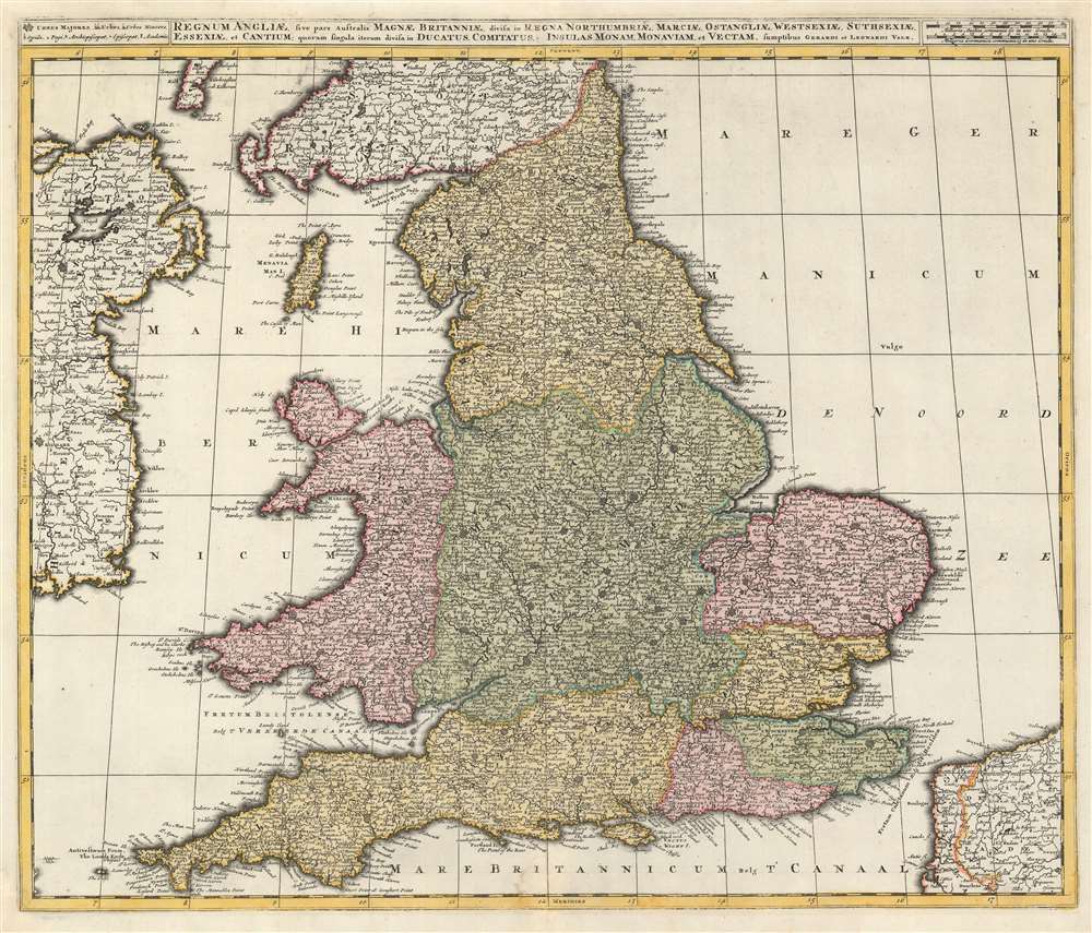

Title
Regnum Angliae, sive pars Australis Magnae Britanniae, divisa in Regna Northumbriae, Marciae, Ostangliae, Westsexiae, Suthsexiae, Essexiae, et Cantium; quorum singula iterum divisa in Ducatus, Comitatus, Insulas Monam, Monaviam, et Vectam.
1724 (undated) 20.5 x 24 in (52.07 x 60.96 cm) 1 : 1420000
1724 (undated) 20.5 x 24 in (52.07 x 60.96 cm) 1 : 1420000
Description
This is a 1724 Gerard and Leonard Valk map of England and Wales. The map depicts the region from eastern Ireland to the North Sea and from Scotland to the English Channel, northern France (Pas de Calais and Nord departments), and Belgium. Highly detailed, myriad cities, towns, and villages are labeled throughout the entire region, not just in England and Wales. Some of the identified cities include London, Southampton, Cambridge, Newcastle, and Cardiff (Caerdyf), along with Belfast in Ireland, and Calais and Dunkirk in France. Seven geographical regions within England are shaded different colors to allow for easy differentiation, including East Anglia, Northumbria, Essex, and Sussex. Wales is also differentiated by color. The Isle of Man is depicted in the Irish Sea between England and Ireland.
Publication History and Census
This map was created by Gerard and Leonard Valk in 1724. We believe this map to quite rare, as it is part of only one known institutional collection at the Bavarian State Library in Munich and has no known market history.Cartographer
Gerard Valk (September 30, 1652 - October 21, 1726) (aka. Valck, Walck, Valcke), was a Dutch engraver, globe maker, and map publisher active in Amsterdam in the latter half of the 17th century and early 18th century. Valk was born in Amsterdam where his father, Leendert Gerritsz, was a silversmith. He studied mathematics, navigation, and cartography under Pieter Maasz Smit. Valk and moved to London in 1673, where he studied engraving under Abraham Blooteling (or Bloteling) (1634 - 1690), whose sister he married, and later worked for the map sellers Christopher Browne and David Loggan. Valke and Blooteling returned to Amsterdam in 1680 and applied for a 15-year privilege, a kind of early copyright, from the States General, which was granted in 1684. In 1687, he established his own firm in Amsterdam in partnership with Petrus (Pieter) Schenk, who had just married his sister, Agata. They published under the imprint of Valk and Schenk. Also, curiously in the same year Valk acquired the home of Jochem Bormeester, also engraver and son-in-law of art dealer Clement De Jonghe. Initially Valk and Schenk focused on maps and atlases, acquiring the map plates of Jodocus Hondius and Jan Jansson in 1694. Later, in 1701 they moved into the former Hendrick Hondius (the younger) offices where they began producing globes. Valk and Schenk soon acquired the reputation of producing the finest globes in the Netherlands, a business on which they held a near monopoly for nearly 50 years. In 1702, Valk joined the Bookseller's Guild of which he was promptly elected head. Around the same time, Gerard introduced his son, Leonard, who was married to Maria Schenk, to the business. Leonard spearheaded the acquisition of the map plates of Frederick de Wit in 1709. Nonetheless, Leonard was nowhere near as sophisticated a cartographer or businessman as his father and ultimately, through neglect, lost much the firm's prestige. After his death, the firm was taken over by his widow Maria. More by this mapmaker...
Condition
Very good. Blank on verso.
References
OCLC 165137613.